Extensions for ArcGIS
ArcGIS Extensions is a core feature in ArcGIS Software. You can can’t perform multiple tasks except this all extensions.
ArcGIS extensions helps to, perform GIS analysis, applications, services, and other geographic information. Some extensions enhance general analysis and productivity, and others provide solutions for specific industries.
Portal for ArcGIS is an extensions to ArcGIS Server that allows you to share maps, applications, services, and other geographic information.
Enabling Extensions in ArcGIS
To Enable or Disable extensions, Click Customize on the Main toolbar and select Extensions.
Here you can see the selection of extensions available depending on your ArcGIS Software license.
The Extensions dialog box are open, see list of extensions. Click the check box to enable it, and also disable, Click close button to close dialog box.
Overview of ArcGIS Extensions
- 3D Analyst
- ArcScan
- Geostatistical Analyst
- Network Analyst
- Publisher
- Schematics
- Spatial Analyst
- Tracking Analyst
- Data Interoperability
- Data Reviewer
- Workflow Manager (Classic)
| Extensions | Description |
|---|---|
| 3D Analyst | ArcGIS 3D Analyst extension to be a fully functioning of 3D GIS system. It allows you to view, manage, analyze, and share your 3D GIS data. View global 3D GIS data using ArcGlobe, or view site-level data in a local coordinate system using ArcScene. |
| Geostatistical Analyst | The Geostatistical Analyst provides tools for analyzing and mapping continuous datasets and surface generation. Exploratory spatial data analysis tools provide insights about data distribution, global and local outliers, global trends. Also it’s offer spatial autocorrelation, and variation among multiple datasets. |
| Network Analyst | Perform advanced routing and network analysis supporting- Drive-time analysis, Point-to-point routing, Route directions, S ervice area define, Shortest path analysis, Closest facility analysis, Origin destination analysis, Gravity or Huff models, etc. |
| ArcGIS Schematics | Generate, visualize, and manipulate diagrams from network data coming from a geodatabase or any data that has explicit attributes showing connectivity. Use a number of schematic representations: Geographic, Geoschematic, and schematic. Generate schematics from complex networks, Visualize both logical and physical connectivity. Evaluate network forecast and planning. Visualize nonspatial, connected data, and more. |
| Spatial Analyst | Spatial Analyst extension of powerful raster modeling and analysis features allow to create, query, map, and analyze raster data. Arc GIS Spatial Analyst extension also allows integrated raster and vector analysis and adds more than 170 tools to the ArcGIS Geoprocessing framework. |
| Tracking Analyst | Tracking Analyst supports network connections to Global Positioning System (GPS) units and other tracking and monitoring devices, so you can map your data in real time. Analyze patterns in temporal data by creating data clocks. Create and apply actions on temporal data, and also create animations of your data using the Tracking Analyst Animation tool. View tracking data in 3D using ArcGlobe. |
| ArcGIS Data Interoperability | GIS data can be delivered in a variety of formats. For ex; data sources, such as advanced computer-aided design (CAD) datasets with extended entity attributes, MapInfo datasets, Intergraph GeoMedia datasets, and various GML files, can be accessed, displayed, and used directly in Arc GIS. Arc GIS Data Interoperability extension is a separate setup available on the Arc GIS Desktop media. |
| ArcGIS Data Reviewer | Analyze and validate data that allow to check for both spatial and attribution conditions. Additionally, also be sample data, validate metadata values against a schema, and check valency on network features. The results of the analysis or validation are stored in a table, where you can update the correction or verification status. |
| ArcScan for ArcGIS | Perform raster to vector conversion tasks on scanned documents, including raster editing, raster snapping, manual raster tracing, and vectorization. |
| ArcGIS Publisher | Publish data, maps, and globes authored using ArcGIS Desktop, with ArcMap and ArcGlobe. Author interactive maps and globes, publish them with Arc GIS Publisher, and share them via ArcReader. |
3D Analyst Extension
The 3D Analyst toolbar allows only ArcMap and ArcScene, and the 3D View Tools and Globe View Tools toolbars allow only ArcCatalog.
Enabling 3D Analyst extension, Click the Customize menu, and select Extensions. In the Extensions dialog box, Check 3D Analyst to enable it and close the dialog box.
Enabling the 3D Analyst toolbars, Click Customize menu, Point to Toolbars, select 3D Analyst.
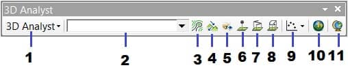
- 3D Analyst Options
- 3D Analyst Layer
- Create Contours
- Create Steepest Path
- Create Line of Sight
- Interpolate Point
- Interpolate Line
- Interpolate Polygon
- Create Profiles
- Open ArcScene
- Open ArcGlobe
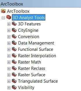
3D Analyst Geoprocessing tools
ArcGIS 3D Analyst Geoprocessing tools are categorized into toolsets depending on the task type and the desired input or output feature class. It can be perform multiple tasks, like; TINs, Rasters, Terrain surfaces, and more.
ArcScan Extension
The ArcScan toolbar helps you to convert scanned images into vector-based feature layers. It’s allow Vectorization can be performed by interactive tracing raster cells or automatically vector tracing.
Enabling ArcScan extension, Click the Customize menu, and select Extensions. In the Extensions dialog box, Check ArcScan to enable it and close the dialog box.
Enabling the ArcScan toolbars, Click Customize menu, Point to Toolbars, select ArcScan.
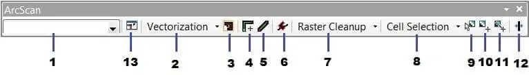
- ArcScan Raster Layer
- Vectorization Settings
- Generate Feature Inside Area
- Vectorization Trace
- Vectorization Trace between Points
- Shape Recognition
- Raster Cleanup
- Cell Selection
- Select Connected Cell
- Find Connected Cell Area
- Find Diagonal of the Envelope of Connected Cell
- Raster Line Width
- Raster SnappingGeostatistical Analyst Options
Geostatistical Analyst Extension
The Geostatistical Analyst extension provides the capability for surface modeling using deterministic and geostatistical methods.
Enabling Geostatistical Analyst extension, Click the Customize menu, and select Extensions. In the Extensions dialog box, Check Geostatistical Analyst to enable it and close the dialog box.
Enabling the Geostatistical Analyst toolbars, Click Customize menu, Point to Toolbars, select Geostatistical Analyst.
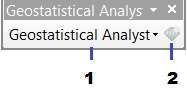
- Geostatistical Analyst Options
- Geostatistical Wizard
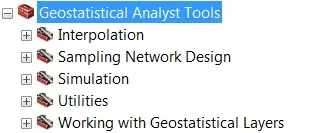
Geostatistical Analyst tools into five toolsets:
Network Analyst Extension
The Network Analyst extension helps you to transport analysis, like finding the Best Route, Calculating Service Areas, Closest Facility, and more.
Enabling Network Analyst extension, Click the Customize menu, and select Extensions. In the Extensions dialog box, Check Network Analyst to enable it and close the dialog box.
Enabling the Network Analyst toolbars, Click Customize menu, Point to Toolbars, select Network Analyst.
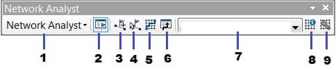
- Network Analyst Options
- Network Analyst Window
- Create Network Location Tool
- Select/Move Network Location Tool
- Solve
- Directions
- Active Network Dataset
- Network Identify Tool
- Build Network Dataset
The Network Analyst geoprocessing tools to perform network analysis and work with network datasets and turn features.
Publisher Extension
Enabling Publisher extension, Click the Customize menu, and select Extensions. In the Extensions dialog box, Check Publisher to enable it and close the dialog box.
Enabling the Publisher toolbars, Click Customize menu, Point to Toolbars, select Publisher .
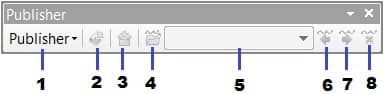
- Publisher Options
- Publish Map
- Create Data Package
- Import ArcReader Markup
- Choose ArcReader Markup Tag
- Previous ArcReader Markup
- Next ArcReader Markup
- Delete ArcReader Markup
Schematics Extension
Enabling Schematics extension, Click the Customize menu, and select Extensions. In the Extensions dialog box, Check Schematics to enable it and close the dialog box.
Enabling the Schematics toolbars, Click Customize menu, Point to Toolbars, select Schematics.
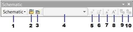
- Schematic Options
- Open Schematic Diagram
- Generate New Schematic Diagram
- Active Diagram
- Decrease Symbol Sizes
- Increase Symbol Sizes
- Decrease Label Sizes
- Increase Label Sizes
- Propagate Schematic Selection to Map
- Propagate Map Selection to Schematic
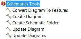
The Schematics geoprocessing tools to perform create and update diagram, and convert diagram to features.
Spatial Analyst Extension
Enabling Spatial Analyst extension, Click the Customize menu, and select Extensions. In the Extensions dialog box, Check Spatial Analyst to enable it and close the dialog box.
Enabling the Spatial Analyst toolbars, Click Customize menu, Point to Toolbars, select Spatial Analyst.
- Spatial Analyst Layer
- Create Contour
- Create Histogram
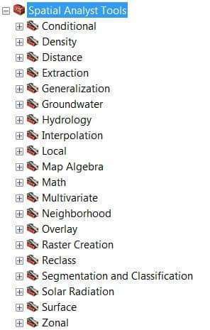
Spatial Analyst provides over 180 geoprocessing tools into 20 toolsets to perform spatial analysis operations.
Tracking Analyst Extension
Enabling Tracking Analyst extension, Click the Customize menu, and select Extensions. In the Extensions dialog box, Check Tracking Analyst to enable it and close the dialog box.
Enabling the Tracking Analyst toolbars, Click Customize menu, Point to Toolbars, select Tracking Analyst.
- Tracking Analyst Options
- Add Temporal Data Wizard
- Playback Manager
- Track Manager
- Tracking Services Monitor
The Tracking Analyst tools helps you to create Tracking Layer and designed for mapping objects that move or change status through time.
Data Interoperability Extension
Enabling Data Interoperability extension, Click the Customize menu, and select Extensions. In the Extensions dialog box, Check Data Interoperability to enable it and close the dialog box.
Data Reviewer Extension
Enabling Data Reviewer extension, Click the Customize menu, and select Extensions. In the Extensions dialog box, Check Data Reviewer to enable it and close the dialog box.
Workflow Manager (Classic) Extension
Enabling Workflow Manager extension, Click the Customize menu, and select Extensions. In the Extensions dialog box, Check Workflow Manager to enable it and close the dialog box.
Overview of ArcGIS Pro Extensions
Advanced Analysis Extensions
| Extensions | Description |
|---|---|
| 3D Analyst | The 3D Analyst extension provides tools to create and analyze surfaces and other 3D data. You can manage Lidar data, evaluate the geometric properties of 3D features, and use TINs as an elevation source. |
| Business Analyst | The Business Analyst extension provides tools to perform GIS operations fundamental to market analysis. You can perform demographic reporting, review customer and competitor distributions, identify key trade areas, and visualize data variables. |
| Geostatistical Analyst | The Geostatistical Analyst extension provides tools for advanced surface modeling and data exploration. You can create interpolation models with a variety of statistical techniques in order to identify trends, spatial variation, clustering, and more. |
| Image Analyst | The Image Analyst extension provides tools for the visualization, measurement, and analysis of image data. You can perform image classification, and analyze image data using a variety of image processing tools and functions. |
| Network Analyst | The Network Analyst extension provides transportation network-based analysis tools for solving complex routing problems. It uses a configurable utility network or transportation network data model. |
| Spatial Analyst | The Spatial Analyst extension provides tools for creating and integrated analysis of raster and vector data. You can derive surfaces, such as slope and aspect, from digital elevation models. |
Data and Workflows Extensions
| Extensions | Description |
|---|---|
| Data Interoperability | The Data Interoperability extension is an extract, transform, load (ETL) toolset for spatial and nonspatial data. The extension allows ArcGIS Pro to import, use, and export hundreds of file, database, and web data formats. Also, you can create custom spatial data formats based on built-in formats and transformers. |
| Data Reviewer | The Data Reviewer extension provides tools to automate and simplify your data quality control process. You can review your data for errors through automated or visual means, and centrally manage correction and verification procedures. |
| Indoors | The Indoors extension allows you to configure data and maps that are used by the following applications: Indoor Viewer, ArcGIS Indoors for iOS, and ArcGIS Indoors for Android. |
| LocateXT | The LocateXT extension provides tools to extract geographic coordinates, place-names, and other location-based data from unstructured text and convert the information to a point feature class. |
| Parcels | Parcel fabrics provide a comprehensive framework for managing, editing, and sharing parcel data in multiuser and single-user environments. |
| Publisher | The Publisher extension allows you to share mobile map packages directly with Explorer for ArcGIS mobile app users. Users can open the map package and use the map without signing in to ArcGIS Online. |
| StreetMap Premium | ArcGIS StreetMap Premium extension provides enriched street data for multiscale cartographic mapping, accurate geocoding, and optimized network analysis, including routing and driving directions. |
| Territory Design | The Territory Design extension provides tools to build, edit, balance, and maintain territories for point and polygon datasets. You can automatically create, balance, and edit sales regions, service areas, or franchise zones. |
| Workflow Manager | The Workflow Manager extension is the desktop component of the service-based architecture It is allows you to create seamless, end-to-end workflows across desktop, web, and mobile platforms. |
| Workflow Manager (Classic) | ArcGIS Manager Classic is the traditional version of Workflow Manager that helps you standardize, manage, and track GIS work. You can represent complex processes as step-based workflows, and track and report job progress at each stage of the workflow. |
Industry related Extensions
| Extensions | Description |
|---|---|
| Aviation Airports | The Aviation Airports extension provides tools to help ensure that operational data meets airport regulatory requirements. It’s includes automated import and export between geodatabase feature classes and shapefiles. |
| Aviation Charting | The Aviation Charting extension provides tools to create navigational products for aviation, efficiently manage aviation data, and comply with regulatory standards in an enterprise environment. |
| Defense Mapping | The Defense Mapping extension provides tools for specialized data collection and attribution, geodatabase maintenance, and data validation. |
| Maritime | The Maritime extension provides tools to manage hydrographic information. You can create, import, symbolize, manage, and store S-100 vector-based products. |
| Pipeline Referencing | The Pipeline Referencing extension provides tools for building and maintaining a linear referencing system (LRS) network for pipelines. The extension offers a predefined data model and also allows you to define your own data model. |
| Production Mapping | The Production Mapping extension provides tools to standardize and streamline GIS workflows across your enterprise in the areas of topographic map production, geographic feature collection, and data management. |
| Roads and Highways | ArcGIS Roads and Highways provides tools to visualize and maintain roadway LRS networks and associated event data. |