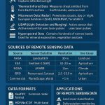
Orthorectification
What is Orthorectification?
Orthorectification is a form of rectification that corrects for terrain displacement and can be used if there is a DEM of the study area. It is based on collinearity equations, which can be derived by using 3D GCPs. In relatively flat areas, ortho-rectification is not necessary, but in mountainous areas where a high degree of accuracy is required, ortho-rectification is recommended.
Process of Orthorectification
Ortho-rectification is the process of removing geometric errors inherent within photography and imagery. The variables contributing to geometric errors include, but are not limited to:
- Camera and sensor orientation
- Systematic error associated with the camera or sensor
- Topographic relief displacement
- Earth curvature
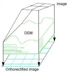
This is a process takes the raw digital imagery and applies a DEM and triangulation results to create an orthorectified image. Once an orthorectified image is created, each pixel within the image possesses geometric fidelity. Thus, measurements taken off an orthorectified image represent the corresponding measurements as if they were taken on the Earth’s surface.
Orthorectification vs Georectification
- Georectify take an image that has not been adjusted to be in a known coordinate system, and put it into a known coordinate system.
- Orthorectify take an image in its original geometry and very accurately adjust it so that it is in a known coordinate system, with distortions due to topographic variation corrected.