Concept of Remote Sensing (RS)
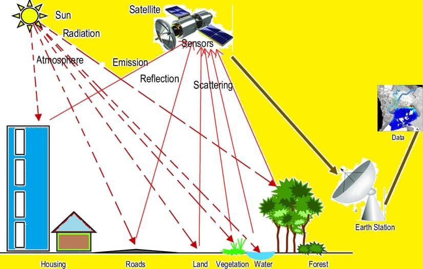
Remote Sensing (RS) is the acquiring of Data about an object without touching it.
What is Remote Sensing and How it’s Work
Remote Sensing is the art and science of obtaining information about an object or feature without physically coming into contact. The data collected can be of many forms: variations in acoustic wave distributions (sonar), force distributions (gravity meter), electromagnetic energy distributions (eye), etc.
The Remote Sensing process of inferring surface parameters from measurements of the Electromagnetic Radiation (EMR) from the Earth’s surface. EMR can either be reflected or emitted from the Earth’s surface.
Electromagnetic Radiation (EMR)
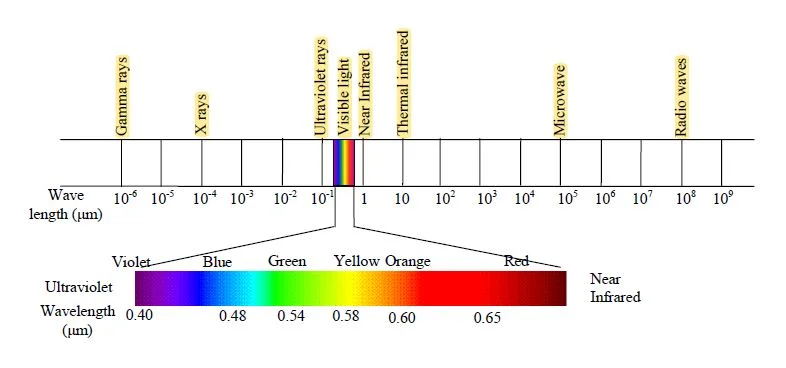
Electromagnetic Radiation (EMR) or Electromagnetic energy is the energy propagated in the form of an advancing interaction between electric and magnetic fields. It travels with the velocity of light. Visible light, ultraviolet, and infrared rays, heat, radio waves, X-rays all are different forms of electromagnetic energy.
Electromagnetic Spectrum (EMS)
The Electromagnetic Spectrum is represented by Electromagnetic waves. It’s characterized by their wavelength or frequency, linked by the speed of light. The frequency is associated with energy. High frequency is high energy.
Elements of Remote Sensing
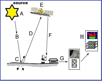
A. Emission of electromagnetic radiation. (The Sun or an EMR source located on the platform)
B. The Transmission of energy from the source to the object. (Absorption and scattering of the EMR while transmission)
C. Interaction of EMR with the object and subsequent reflection and emission
D. Transmission of energy from the object to the sensor
E. Recording of energy by the sensor. (Photographic or non-photographic sensors)
F. In Transmission of the recorded information to the ground station
G. Processing of the data into digital or hard copy image
H. Analysis of data
Active and Passive Remote Sensing
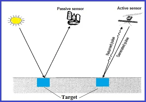
Active Sensor
Have its source of light or illumination and its sensor measures reflected energy.
In the case of Active Remote Sensing, energy is generated and sent from the RS platform towards the targets. The energy reflected from the targets is recorded using sensors onboard the RS platform. Most of the microwave RS is done through Active RS.
Passive Sensor
Measure reflected sunlight that was emitted from the sun.
Passive Remote Sensing, the source of energy is that naturally available, such as the Sun. Most of the RS systems work in passive mode, using solar energy as the source of EMR. Solar energy reflected by the targets at specific wavelength bands is recorded using sensors onboard air-borne or space-borne platforms.
Remote Sensing Platforms
RS platforms can be classified as follows, based on the elevation from the Earth’s surface at which these platforms are placed.
There are three types of platform:
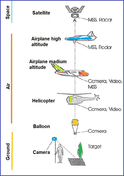
1. Ground borne Remote Sensing
- Ground-level remote sensors are very close to the ground.
- They are used to developing and calibrate sensors for different features on the Earth’s surface.
2. Airborne Remote Sensing
- Low altitude aerial remote sensing
- High altitude aerial remote sensing
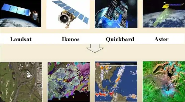
3. Space-borne Remote Sensing
- Space shuttles
- Polar-orbiting satellites
- Geo-stationary satellites
Sensor Resolution
Resolution is commonly used to describe the number of pixels display on a display device, or area on the ground that a pixel represents in an image file.
Four distinct types of the Resolution must be considered:
- Spectral—specific wavelength intervals that a sensor can record
- Spatial—area on the ground represented by each pixel
- Radiometric—number of possible data file values in each band
- Temporal—how often a sensor obtains imagery of a particular area
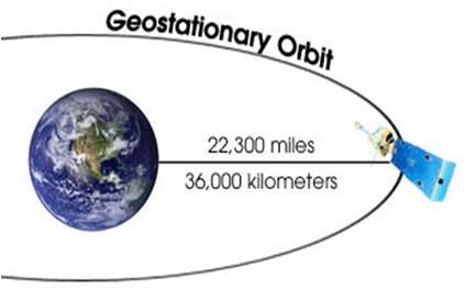
Satellite Orbits
There are three types of Satellite:
Geostationary Satellite
A Geostationary Satellite is one of the satellites which is getting remote sense data and located satellite at an altitude of approximately 36,000 kilometers and directly over the equator.
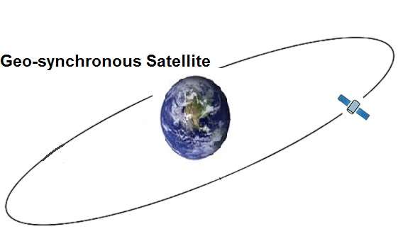
Geo-synchronous Satellite
Geo-synchronous Satellite is placed in the geosynchronous orbit, and Earth-centered orbit with an orbital period that matches Earth’s rotation on its axis, 23 hours, 56 minutes, and 4 seconds.
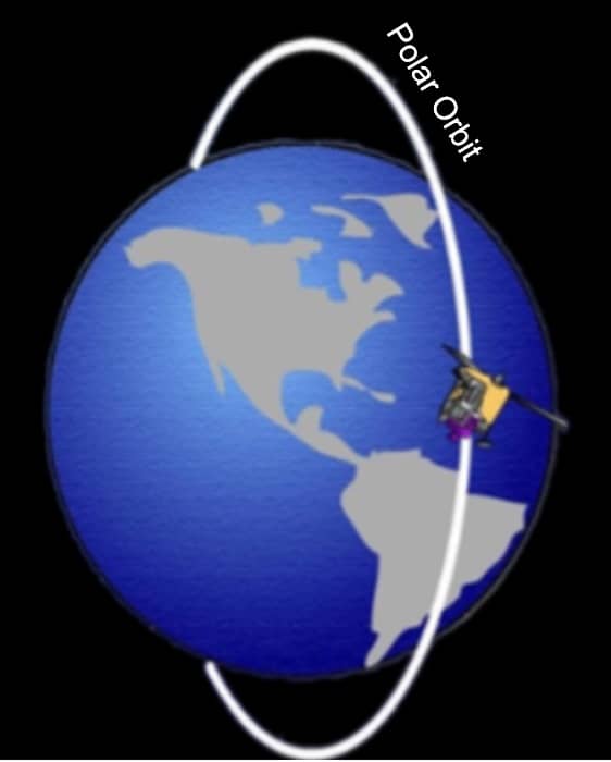
Polar-Orbiting Satellite
A Polar orbit is a satellite travels north-south over the poles and takes approximately an hour and a half for a full rotation. This satellite mostly used for Earth-mapping, observation, capturing the Earth as time passes from one point.
Application of Remote Sensing
The Remote Sensing Applications are:
- Agriculture – Crop monitoring, soil mapping.
- Forestry – Deforestation tracking, biomass estimation.
- Disaster Management – Flood, fire, earthquake monitoring.
- Urban Planning – Sprawl detection, infrastructure monitoring.
- Climate Studies – Glacial retreat, sea level rise.
Advantages and Disadvantages of Remote Sensing
Advantages–
a) Provides data from large areas
b) Provides data on very remote and inaccessible regions
c) Able to obtain imagery of any area over a continuous period through which any anthropogenic or natural changes in the landscape can be analyzed
d) Relatively inexpensive when compared to employing a team of surveyors
e) Easy and rapid collection of data
Disadvantages–
a) The interpretation of imagery requires a certain skill level
b) Needs cross verification with ground (field) survey data
c) Data from multiple sources may create confusion
d) Objects can be misclassified or confused
e) Distortions may occur in an image due to the relative motion of sensor and source
Wohh exactly what I was searching for, thanks for putting up.
Nice post. I learn something totally new and challenging onn
websites I stumbleupon on a daily basis. It will always be useful to
read articles from other writers and practice something feom their sites.