Sensor Resolution in Remote Sensing
Resolution in Remote Sensing refers to the level of detail that a sensor can capture. There are four primary types of resolution, each representing a different aspect of image quality and utility.
What is Remote Sensing Resolution?
Resolution is a broad term commonly used in Remote Sensing.
The Resolution is several pixels display on a display device, or area on the ground that a pixel represents in an image file.
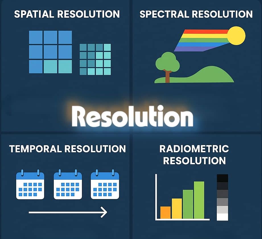
4 distinct types of resolution must be considered:
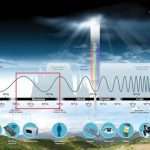
- Spectral—specific wavelength intervals that a sensor can record
- Spatial—area on the ground represented by each pixel
- Radiometric—number of possible data file values in each band
- Temporal—how often a sensor obtains imagery of a particular area
Comparison of Landsat Sensors
| Resolutions | Thematic Mapper (TM) Landsat 4 and 5 | Enhanced Thematic Mapper Plus (ETM+) Landsat 7 | Multispectral Scanner (MSS) Landsat 1-5 |
|---|---|---|---|
| Spectral Resolution (μm) | 1. 0.45-0.52 (B) 2. 0.52-0.60 (G) 3. 0.63-0.69 (R) 4. 0.76-0.90 (NIR) 5. 1.55-1.75 (MIR) 6. 2.08-2.35 (MIR) 7. 10.4-12.5 (TIR) | 1. 0.45-0.52 2. 0.53-0.61 3. 0.63-0.69 4. 0.78-0.90 5. 1.55-1.75 6. 2.09-2.35 7. 10.4-12.5 8. 0.52-0.90 (Pan) | 0.5-0.6 (green) 0.6-0.7 (red) 0.7-0.8 (NIR) 0.8-1.1 (IR) |
| Spatial Resolution (meter) | 30 x 30 120 x 120 (TIR) | 15 x 15 (Pan) 30 x 30 60 x 60 (TIR) | 79 x 79 |
| Spatial coverage (km) | 185 x 185 | 183 x 170 | 185 x 185 |
| Temporal Resolution (days) | 16 | 16 | 18 |
| Altitude (km) | 705 | 705 | 915 (Landsat 1,2,3) |
Types of Resolution in Remote Sensing
Spectral Resolution in Remote Sensing
Spectral resolution refers to the specific wavelength intervals in the Electromagnetic spectrum that a sensor can record (Simonett et al., 1983). For example, band 1 of the Landsat TM sensor records energy between 0.45 and 0.52 μm in the visible part of the spectrum.
Wide intervals in the electromagnetic spectrum are referred to as coarse spectral resolution, and narrow intervals are referred to as fine spectral resolution. For example, the SPOT panchromatic sensor is considered to have coarse spectral resolution because it records EMR between 0.51 and 0.73 μm.
On the other hand, band 3 of the Landsat TM sensor has a fine spectral resolution because it records EMR between 0.63 and 0.69 μm (Jensen, 1996).
Spatial Resolution in Remote Sensing
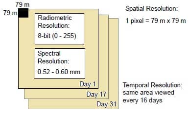
Spatial resolution is a measure of the smallest object that can be resolved by the sensor, or the area on the ground represented by each pixel (Simonett et al, 1983). The finer the resolution, the lower the number. For instance, a spatial resolution of 79 meters is coarser than a spatial resolution of 10 meters.
Seale
Large-scale in remote sensing refers to imagery in which each pixel represents a small area on the ground, such as SPOT data, with a spatial resolution of 10m or 20 m. Small scale refers to imagery in which each pixel represents a large area on the ground, such as Advanced Very High Resolution Radiometer (AVHRR) data, with a spatial resolution of 1.1 km.
IFOV
Spatial resolution is also described as the Instantaneous Field of View (IFOV) of the sensor, although the IFOV is not always they same as the are represented by each pixel. The IFOV is a measure of the area viewed by a single detector in a given instant in time (Star and Estes, 1990).
For example, Landsat MSS data have an IFOV of 79 × 79 meters, but there is an overlap of
11.5 meters in each pass of the scanner, so the actual area represented by each pixel is 56.5 × 79 meters.
Radiometric Resolution in Remote Sensing
Radiometric resolution refers to the dynamic range, or number of possible data file values in each band. This is referred to by the number of bits into which the recorded energy is divided.
In 8-bit data, the data file values range from 0 to 255 for each pixel, but in 7-bit data, the data file values for each pixel range from 0 to 128.
The sensor measures the EMR in its range. The total intensity of the energy from 0 to the maximum amount of the sensor measures is broken down into 256 brightness values for 8-bit data, and 128 brightness values for 7-bit data.
Temporal Resolution in Remote Sensing
Temporal resolution refers to how often a sensor obtains imagery of a particular area. For example, the Landsat satellite can view the same area of the globe once every 16 days. On the other hand, SPOT can revisit the same area every three days.
Resolution of various satellites
| Sl.No. | Satellite | Sensor | Temporal resolution | Spectral resolution | Spatial resolution |
|---|---|---|---|---|---|
| 1. | NOAA-17 National Oceanic and Atmospheric Administration | AVHRR-3 Advanced Very High Resolution Radiometer | 2-14 times per day | 0.58-0.68(1), 0.73-1.00(2), 1.58-1.64 (3A day) 3.55 -3.93 (3B night) 10.3-11.3(4) 11.5-12.5(5) | 1 Km X 1Km (at nadir) 6 Km X 2Km (at limb) |
| 2. | Landsat | MSS Multispectral scanner | 18 days | 0.5-0.6 0.6-0.7 0.7-0.8 0.8-1.1 | 79/82m 79/82m 79/82m 79/82m 79/82m |
| TM The Thematic Mapper | 18 days | 0.45-0.52(1) 0.52-0.60(2) 0.63-0.69(3) 0.76-0.90(4) 1.55-1.75(5) 10.4-12.5(6) 2.08-2.35(7) | 30m 30m 30m 30m 30m 120m 30m | ||
| ETM+ Enhanced Thematic Mapper | 16 days | All TM bands + 0.50-0.90 (PAN) | 15m(PAN) 30m (band 1-5,7) 60m (band 6) | ||
| 3. | Terra | ASTER Advanced Spaceborne Thermal Emission and Reflectance Radiometer | 5 days (VNIR) | VIS (BANDS 1-2), 0.56, 0.66, NIR 0.81, SWIR (4-9), 1.65, 2.17, 2.21, 2.26, 2.33, 2.40, TIR (bands 10-14) 8.3, 8.65, 9.10, 10.6, 11.3 | 15m(VNIR) 30m (SWIR) 90m(TIR) |
| 4. | SPOT-5 Systeme Pour I ‘Observation de la Terre | 2 X HRG (High resolution Geometric ) and HRS High Resolution Streoscopic | 2-3 days | 0.50-0.59 0.61-0.68 0.78-0.89 (NIR) 1.58-1.75 (SWIR) 0.48-0.70 (PAN) | 10m, 5m (PAN) |
| 5. | Resourcesat 1 | LISS 4 Linear Imaging Self Scanning | 5-24 days | 0.56, 0.65, 0.80 | 6m |
| 6. | Ikonos | Optical Sensor Assembly(OSA) | 1-3 days | 0.45-0.52(1), 0.52-0.60(2), 0.63-0.69(3), 0.76-0.90(4), 0.45-0.90 (PAN) | 1m (PAN) 4m (bands 1-4) |
| 7. | EO-1 Earth Observing | CHRIS (Compact High Resolution Image Spectrometer) | Less than 1 week typically 2-3 days | 19 or 63 bands 410 nm-1050 nm | 18m (full spatial resolution) 36(full spectral resolution) |
| 8. | EO-1 | Hyperion | 16 days | 220 bands | 30 m |
| 9. | Envisat-1 | ASAR | 35 days | C-band, 5.331 GHz | 30m-150m (depending on mode) |
| MERIS | 3 days | 1.25 nm to 25 nm 15m bands | 300m (land) 1200m(ocean) | ||
| 10. | IRS (Indian Remote Sensing)-1A, 1B, 1C, 1D, P6 | LISS-III, LISS-IV | 24 days | 0.52-0.59µm 0.62-0.68 µm 0.77-0.86µm 1.55-1.70µm 0.5-0.75 µm (Panchromatic) | 23 m resolution (70m in mid IR)(LISS III ), 5.8 m(LISS-IV) |
| Panchromatic | 5 days | 5.8m | |||
| Wide Field Sensor (WiFS) | 3 days | 188m | |||
| 11. | Quick Bird | Panchromatic Multispectral | 1-5 days | Blue (450-520 nm) Green (520-600 nm) Red (630-690 nm) Near IR (760-900nm) | 60-70cm (panchromatic sensor) 2.4m-2.8m (Multispectral) |
| 12. | Cartosat I,II | Panchromatic | 4-5 days | 0.50-0.85µm | 2.5m, less than 1 meter |
Comparison of Remote Sensing Resolutions
| Type of Resolution | Key Feature | Typical Values | Example Sensors | Use Cases |
|---|---|---|---|---|
| Spatial | Pixel size | 0.3 m – 1000 m | WorldView-3, MODIS | Urban mapping, land use |
| Spectral | Number & width of bands | 3 (RGB) to 200+ (hyperspectral) | Landsat, Sentinel-2, AVIRIS | Vegetation, water quality |
| Temporal | Revisit time | Minutes to 16 days | MODIS (daily), Sentinel-2 (5 days) | Crop monitoring, disaster detection |
| Radiometric | Bit depth | 8-bit (256) to 16-bit (65,536) | Landsat 8 (12-bit), Sentinel-2 (12-bit) | Detecting subtle brightness changes |