Thermal Infrared Remote Sensing
What is Thermal Infrared?
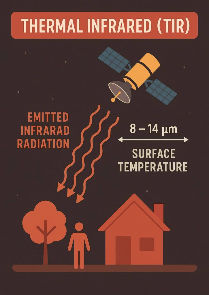
Thermal Infrared (TIR) is an energy heat, Remote Sensing records the radiant temperature of the object.
TIR refers to a portion of the electromagnetic spectrum that detects heat emitted by objects, rather than reflected sunlight. It typically covers Wavelength of between 3 and 20 micrometers (nm).
Characteristics of TIR:
- Most remote sensing applications make use of the 3 to 5 and 8 to 14 micrometer range.
- The main difference between thermal infrared and near infrared is that thermal infrared is emitted energy, whereas the near infrared is reflected energy, similar to visible light.
- All objects having temperature above absolute zero (0 K or -273° C) continuously emits EMR.
- Humans experience this thermal energy primarily through sense of touch.
- Human eyes are not sensitive to the reflective infrared (0.7 – 3.0 mm) or thermal infrared energy (3-5mm & 8-14mm).
- Detectors that are sensitive to thermal infrared radiation allow humans to sense a previously invisible world of information of the landscape.
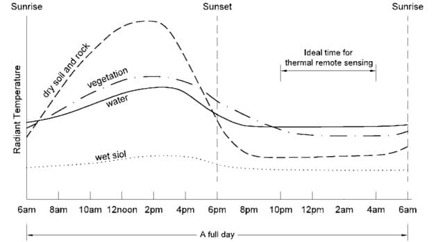
- Thermal remote sensing records the radiant temperature of the object.
- Thermal sensors are typically across-track scanners.
- Images can be captured in day or night.
Wavelength
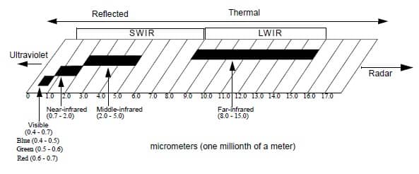
The near-infrared and middle-infrared regions of the Electromagnetic Spectrum are sometimes referred to as the short wave infrared region (SWIR). This is to distinguish this area from the Thermal or far infrared region, which is often referred to as the long wave infrared region (LWIR).
The emissivity of an object is generally considered to be wavelength dependent. For example, while the emissivity of an object is often considered to be constant throughout the 8 – 14 mm region, its emissivity in the 3 -5 mm region may be different
TIR Satellites
| Satellite | Application |
|---|---|
| Landsat 8 (TIRS) | Surface temperature monitoring |
| ASTER | High-res temperature data |
| MODIS | Global coverage |
| VIIRS | Earth observation |
| Sentinel-3 SLSTR | Ocean and land temp |
Sensors
- TIROS (Television IR Operational Satellite), launched in 1960
- GOES (Geostationary Operational Environmental Satellite), TIR at 8 km spatial resolution, full disk of Earth Day and night
- HCMM (Heat Capacity Mapping Mission), launched in 1978- 600 m spatial resolution, 10.5 – 12.6-micron range
- CZCS (Coastal Zone Color Scanner) on Nimbus 7, launched in 1978, for SST
- AVHRR (Advanced Very High Resolution Radiometer), 1.1 and 4 km
- TIR bands TIMS (Thermal Infrared Multispectral Scanner), Airborne, 6 bands
- ATLAS (Airborne Terrestrial Applications Sensor)
- Landsat ETM+ Band 6- 10.4 – 12.5 micron range
- ASTER (Advanced Spaceborne Thermal Emmission and Reflection Radiometer) on Terra, 5 bands :8.125-11.65 micron range
Infrared Detectors
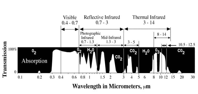
- Electronic detectors can also be made sensitive to photons of thermal infrared radiant energy exiting the terrain in the two primary thermal infrared windows: 3 – 5 mm and 8 – 14 mm. Sub-orbital thermal infrared remote sensing systems utilize these spectral bands.
- The Earth’s ozone (O3) layer absorbs much of the thermal energy exiting the terrain in an absorption band from approximately 9 – 10 mm. Therefore, satellite thermal infrared remote sensing systems usually only record data in the region from 10.5 – 12.5 mm to avoid the absorption band.
TIR Atmospheric Windows
- Beyond the visible region of the electromagnetic spectrum, we encounter the reflective infrared region from 0.7 – 3.0 m m and the thermal infrared region from 3 – 14 m m.
- The only reason we can use remote sensing devices to detect infrared energy in these regions is because the atmosphere allows a portion of the infrared energy to be transmitted from the terrain to the detectors.
- Regions that pass energy are called atmospheric windows. Regions that absorb most of the infrared energy are called absorption bands.
- Water vapor (H2O), carbon dioxide (CO2), and ozone (O3) are responsible for most of the absorption. For example, atmospheric water vapor (H2O) absorbs most of the energy exiting the terrain in the region from 5 to 7 m m making it almost useless for remote sensing.
Thermal Radiation Laws
A blackbody is a theoretical construct that absorbs all the radiant energy striking it and radiates energy at the maximum possible rate per unit area at each wavelength for any given temperature.
No objects in nature are true blackbodies, however, we may think of the Sun as approximating a 6,000 ˚K blackbody and the Earth as a 300 ˚K blackbody.
Stefan Boltzmann Law
- The total spectral radiant flux exitance (Fb) measured in watts/m2 leaving a blackbody is proportional to the fourth power of its temperature (T).
- This is the Stefan-Boltzmann law and is expressed as:
Fb = kT4
- where k is the Stefan-Boltzmann constant equaling 5.6697 x 10⁻⁸W/m2/K4, and T is temperature in degrees Kelvin.
- The Sun produces more spectral radiant exitance (Fb) at 6,000 ˚K than the Earth at 300 ˚K. As the temperature increases, the total amount of radiant energy measured in watts per m2 increases.
Wein’s Displacement Law
The relationship between the true temperature of a blackbody (T) in degrees Kelvin and its peak spectral exitance or dominant wavelength (lmax) is described by Wein’s displacement law:
lmax = k = 2898 mm ˚K
T T
where k is a constant equaling 2898 mm ˚K.
For example, the average temperature of the Earth is 300 ˚K (80 ˚F).
We compute the Earth’s dominant wavelength as:
lmax = 2898 mm ˚K
T
lmax = 2898 mm ˚K = 9.67 mm
300 ˚K
- The dominant wavelength provides valuable information about which part of the thermal spectrum we might want to sense in. For example, if we are looking for 800 ˚K forest fires that have a dominant wavelength of approximately 3.62 mm then the most appropriate remote sensing system might be a 3-5 mm thermal infrared detector.
- If we are interested in soil, water, and rock with ambient temperatures on the earth’s surface of 300 ˚K and a dominant wavelength of 9.66 mm, then a thermal infrared detector operating in the 8 – 14 mm region might be most appropriate.
Use of Thermal Infrared in Remote Sensing
- Close-range terrestrial applications such as residential and commercial heat-loss insulation studies
- Geothermal areas – hot springs, natural geysers, Locating cold water spring
- To find human beings at night
- Variety of medical problems (referred to as thermography)
- Volcanic activity areas
- Allocate fire-fighting resources during a forest fire
- To target enemy facilities as were in the Gulf War in 1991
- Nighttime weather analysis
- Warm Zones in oceans – locating fish