Sonar – Sound Navigation And Ranging
Sonar (Sound Navigation And Ranging) is exploring and mapping the ocean, because sound waves travel farther in the water than do Radar and light waves.
The Sonar is a technique that uses sound propagation to navigate, measure ranging, communicate with or detect objects on or under the surface of the water.
NOAA scientists primarily use sonar to develop nautical charts, locate underwater hazards to navigation, search for and map objects on the seafloor such as shipwrecks, and map the seafloor itself.
Tutorial Contents
Sonar Sensor Types
There are two types of sonar sensor; i)Active and ii)Passive
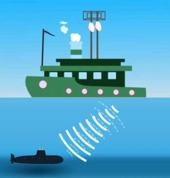
- Active Sonar, is emitting pulses of sounds and listening for echoes. If an object is in the path of the sound pulse, the sound bounces off the object and returns an “echo” to the sonar transducer. If the transducer is equipped with the ability to receive signals, it measures the power of the signal.
- Passive Sonar, is essentially listening for the sound made by vessels. Passive sonar does not emit its own signal, which is an advantage for military vessels that do not want to be found or for scientific missions that concentrate on quietly “listening” to the ocean. it only detects sound waves coming towards i
Application/ Uses for Sonar Data
- Sodar
- Anti-submarine warfare
- Mines
- Submarine navigation
- Aircraft
- Underwater communications
- Ocean surveillance
- Underwater security
- Echo sounding
- Biomass estimation
- Wave measurement
- Water velocity measurement
- Bathymetric mapping
Sonar Sound
Sonar devices send out a sound pulse from a transducer, and then precisely measure the time it takes for the sound pulses to be reflected back to the transducer. The speed of sound in the water approximately 1,500 meters per second.