RADAR- Radio Detection and Ranging
Introduction
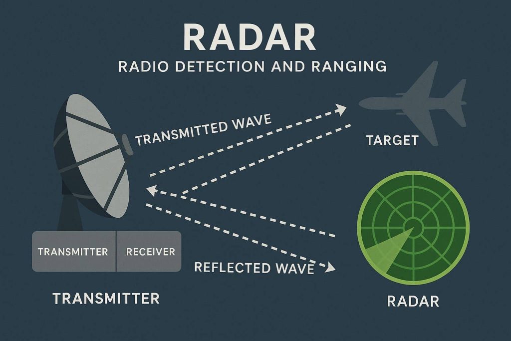
Radio Detection and Ranging (RADAR) is a detection system that uses radio waves to determine the distance, angle, and radial velocity of objects relative to the site. It is widely used in applications ranging from military surveillance to weather forecasting and geographical mapping.
The term Radar was minted in 1940 by the United States Navy as an acronym for radio detection and ranging. It was developed privately for military use by several countries.
Key Components
- Transmitter – Sends out the radio signal.
- Antenna – Directs the signal and collects the return.
- Receiver – Detects and amplifies the returned signal.
- Processor – Analyzes data to extract information.
RADAR Satellite System
A radar system can be Airborne, Spaceborne, or Ground-based.
Airborne Radar system have been mounted on civilian and military aircraft, it was launched in 1978, the radar satellite Seasat-1.
Spaceborne Radar system have been a valuable addition to the data available for use in GIS processing. Researchers are finding that a combination of the characteristics of radar data, visible and infrared data is providing a more complete picture of the Earth.
RADAR Wavelength /Frequency
| Bands | Wavelength (cm) | Frequency (GHz) |
|---|---|---|
| Ka | 0.8 – 1.1 | 40 – 26.5 |
| K | 1.1 – 1.7 | 26.5 – 18.0 |
| Ku | 1.7 – 2.4 | 18.0 – 12.5 |
| X | 2.4 – 3.8 | 12.5 – 8.0 |
| C | 3.8 – 7.5 | 8.0 – 4.0 |
| S | 7.5 – 15 | 4.0 – 2.0 |
| L | 15 – 30 | 2.0 – 1.0 |
| P | 30 – 100 | 1.0 – 0.3 |
RADAR Sensor Types
Radar images are generated by two different types of Sensor: i) SLAR ii) SAR. Both systems are used side-looking geometry.
- SLAR (Side-looking Airborne Radar)
SLAR uses an antenna which is fixed below an aircraft and pointed to the side to transmit and receive the radar signal.
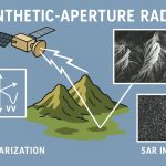
- SAR (Synthetic-aperture Radar)
SAR uses a side-looking, fixed antenna to create a synthetic aperture. This sensors are mounted on satellites and the NASA Space Shuttle. The signals received over a time interval are combined to create the image.
| Type | Description | Application |
|---|---|---|
| Pulsed RADAR | Sends pulses at intervals | Air traffic control, military |
| Continuous Wave (CW) RADAR | Constantly emits signal | Speed detection (e.g., police radar) |
| Synthetic Aperture RADAR (SAR) | High-resolution imaging | Earth observation, geology |
| Doppler RADAR | Measures velocity via frequency shift | Weather radar, storm tracking |
Radar Sensor
- RADARSAT-1
- RADARSAT-2
- Almaz-1
- ALOS PALSAR
- COSMO-SkyMed
- Envisat
- ERS-1
- ERS-2
- JERS-1
- SIR-A
- SIR-B
- SIR-C
- TanDEM-X
- TerraSAR-X
Radar Sensor Data sets
| Sensor | Polarization | Wavelength | Revisit Time |
|---|---|---|---|
| Radarsat-1 | C-HH | 5.6 cm | 24 days |
| Radarsat-2 | C-band dual-pol, quad-pol | 5.6 cm | 24 days |
| ERS-1 ERS-2 | C-VV | 5.7 cm | 35 days (tandem: 24 hrs) |
| JERS-1 | L-HH | 23 cm | 46 days |
| Envisat ASAR | C-band dual-pol | 5.6 cm | 35 days |
| ALOS PALSAR | L-band dual-pol, quad-pol | 23.6 cm | 46 days |
| COSMO-SkyMed | X-band dual-pol | 3 cm | |
| TanDEM-X | X-band dual-pol, quad-pol | 3.1 cm | bistatic |
| TerraSAR-X | X-band dual-pol, quad-pol | 3.1 cm | 11 days |
Application/ Uses for Radar Data
Radar data can be used independently in GIS applications or combined with other satellite data, such as Landsat, SPOT, or AVHRR.
- Geology—radar’s ability to partially penetrate land cover and sensitivity to micro relief makes radar data useful in geologic mapping, mineral exploration, and archaeology.
- Classification—a radar scene can be merged with visible and infrared data as one or more additional layers in vegetation classification for timber mapping, crop monitoring, etc
- Glaciology—radar imagery of ocean and ice phenomena is used for monitoring climatic change through polar ice variation.
- Oceanography—radar is used for wind and wave measurement, sea-state and weather forecasting, and monitoring ocean circulation, tides, and polar oceans.
- Hydrology—radar data are proving useful for measuring soil moisture content and mapping snow distribution and water content.
- Ship monitoring—the ability to provide day and night all-weather imaging, as well as detect ships and associated wakes, makes radar a tool that can be used for ship navigation through frozen ocean areas such as the Arctic or North Atlantic Passage.
- Offshore oil activities—radar data are used to provide ice updates for offshore drilling rigs, determining weather and sea conditions for drilling and installation operations, and detecting oil spills.
- Pollution monitoring—radar can detect oil on the surface of water and can be used to track the spread of an oil spill.
Advantages of Using Radar Data
- Radar microwaves can penetrate the atmosphere day or night under virtually all weather conditions, providing data even in the presence of haze, light rain, snow, clouds, or smoke.
- Under certain circumstances, radar can partially penetrate arid and hyperarid surfaces, revealing subsurface features of the Earth.
- Although radar does not penetrate standing water, it can reflect the surface action of oceans, lakes, and other bodies of water.
- Surface eddies, swells, and waves are greatly affected by the bottom features of the water body, and a careful study of surface action can provide accurate details about the bottom features.
RADAR Weather
See a real view of Earth from space, providing a detailed view of clouds, weather systems, smoke, dust, and fog.
RADAR Weather Map
Current and future radar maps for assessing areas of precipitation, type, and intensity.