Create a Shapefile in ArcGIS & QGIS
In this Tutorial learn, how to create a Shapefiles or Vector file in ArcGIS and QGIS software.
What is Shapefile?
Shapefiles are simple, non-topological Vector format for storing the geometric location and attribute information of geographic features. Geographic features in a shapefile can be represented by points, lines, and polygons.
A shapefile is one of the spatial data formats that you can work with and edit in GIS software like ArcGIS and QGIS.

Shapefile File Extensions
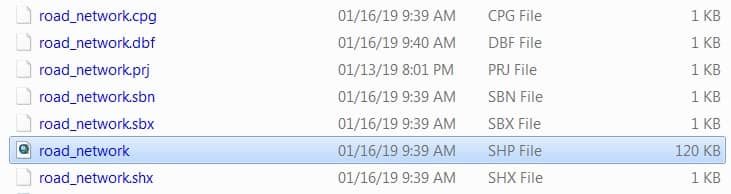
One shapefile format defines 3 or more files with specific file extensions that should be stored in the same project workspace. They are;
Mandatory files:
- .shp—The main file that stores the feature geometry.
- .shx—The index file that stores the index of the feature geometry.
- .dbf—The dBASE table that stores the attribute information of features.
Optional files:
- .sbn and .sbx—The files that store the spatial index of the features.
- .prj—The file that stores the coordinate system information (projection information).
- .cpg—The file that can be used to specify the code page for identifying the character set to be used.
example:
Other files:
- .ain and .aih—The files that store the attribute index of the active fields in a table or a theme’s attribute table.
- .fbn and .fbx—The files that store the spatial index of the features for shapefiles that are read-only.
- .atx—The file is created for each shapefile or dBASE attribute index created in ArcCatalog.
- .ixs— A Geocoding index for read/write shapefiles.
- .mxs—A Geocoding index for read/write shapefiles (ODB format).
- .xml—Stores Metadata information about the shapefile.
Shapefile Data format
The following data types are supported within a shapefile:
- Short Integer
- Long Integer
- Float
- Double
- Text
- Date
Create a Shapefiles (Vector file) in ArcGIS
Learn How to create Vector Data or Shapefile in ArcMap.
1. From the right side, Catalog window selects the folder, click right the button of the mouse, then New > Shapefile.
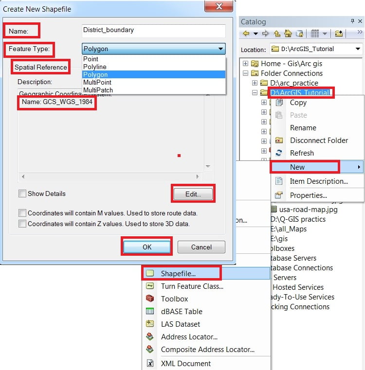
2. In the Create New Shapefile dialog box, write down the name of the shapefile and choose Feature Type.
On the Spatial Reference Section, click the Edit button and select Geographic Coordinate System-WGS 1984. Finally, click the OK button to close the Create New Shapefiles dialog box.
New shapefiles is automatically added in contents (TOC) pane.
Create a Shapefiles (Vector file) in QGIS
Learn How to create Vector Data or Shapefile in QGIS.
Before you can add new vector data, you need a vector dataset to add it to. In our case, you’ll begin by creating new data entirely, rather than editing an existing dataset. Therefore, you’ll need to define your new dataset first.
You’ll need to open the New Vector Layer dialog that will allow you to define a new layer.
1. Navigate to and click on the menu entry Layer > create Layer > New shapefile Layer.
2. It’s important to decide which kind of dataset you want at this stage, basically 3 different types of vector layer (a) Point (b) Line (c) Polygon. For example, create a new Polygon dataset.
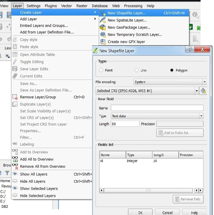
3. Click Polygon ratio button > Coordinate Reference System, or CRS.
The next field allows you to specify the specifies how to describe a point on Earth in terms of coordinates, there are many CRSs. The CRS of this project is WGS84.
It’s already correct by default > click OK a save dialog will appear > go to your destination folder > write name > click OK.
Limitations
- Max file size: ~2 GB
- One geometry type per shapefile (e.g., all points, all lines, or all polygons)
- No support for advanced GIS features like topology or 3D
More Tutorial–

I think this is good page and to support d/t experts so keep up
Thank you Awel