Create New Shapefile in ArcGIS Pro
A Shapefile is a vector file format that stores the location, shape, and attributes of geographic features with the same geometry type that is point, line, and polygon and the same spatial reference. You work with shapefiles in ArcGIS Pro in a similar way to working with feature classes.
The following data types are supported within a shapefile:
- Short Integer
- Long Integer
- Float
- Double
- Text
- Date
How to Create a Shapefile in ArcGIS Pro
Create a Shapefile
To create a new polygon Shapefile in ArcGIS Pro, go under the View tab, Catalog pane, go to folders, right-click on folder, where you went the data set, and select New > Shapefile.
Now it needs a name, geometry type (polygon), and coordinate system.
Create a Layer
Creates a feature layer from an input feature class or layer file in ArcGIS Pro.
Convert a Layer package to a Shapefile
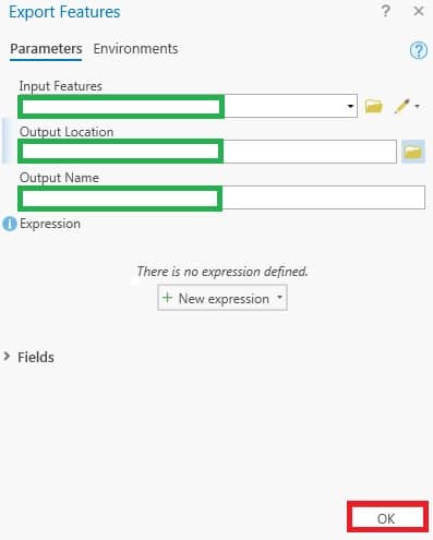
Use the Export Features tool to convert a layer package to a shapefile in ArcGIS Pro.
- In the Catalog tab, right-click Folders, and select Add Folder Connection.
- Select the desired folder containing the layer package file, and click OK to add the folder.
- Right-click the layer package file, and select Add To Current Map.
- In the Contents pane, right-click the feature layer, and navigate to Data > Export Features.
- In the Export Features window appears, specify the Output Location to save the output feature, and specify the Output Name.
Limitations of Shapefiles
- Shapefile size limit- 2 GB.
- Maximum field name length: 10 characters.
- Maximum number of fields: 1024.
- NULL values are only supported on the Date field data type and are not supported for numeric or text field data types in a shapefile.
- A shapefile cannot store topological information or relationships.
- Shapefiles and dBASE files cannot store non-English characters by default. (Follow: How To: Read and write shapefile and dBASE files encoded in various code pages.)
- In the fields view, you can add, delete, or copy fields, but once the field is saved, you cannot alter the field properties.
- Adding an attribute or spatial index is currently not supported for shapefiles on the layer properties indexes tab. See the Indexes toolset.