Feature Class in ArcGIS
What is Feature Class?
Feature classes are spatial representation, such as points, lines, or polygons, and a common set of attribute columns. For example, a Point feature class for representing placemark, such as School, Hospital.
The four most commonly used feature classes are Point, Line, Polygon, and Annotation.
Types of Feature Classes
- Point: Features that are too small to represent as lines or polygons as well as point locations.
- Line: Feature class for representing road centerlines, such as street and streams, too narrow to depict as areas. Lines are also used to represent features that have length but no area, such as contour lines and boundaries.
- Polygon: Features that represents the shape and location of homogeneous feature types such as states, counties, parcels, soil types, and land-use zones.
- Annotation: Map text including properties for how the text is rendered. For example, in addition to the text string of each annotation, other properties are included such as the shape points for placing the text, its font and point size, and other display properties.
What is Feature Class in ArcGIS
Feature class is a collection of geographic features with the same geometry type (point, line, or polygon), the same attributes, and the same spatial reference.
Feature classes stored in Geodatabases can be extended as needed to achieve a number of objectives. In ArcGIS you can extend feature classes using the Geodatabase.
Feature Dataset
A Feature Datasets is a collection of spatially related feature classes that share a common coordinate system.
Their primary purpose is for organizing related feature classes into a common dataset for build topologies, networks, cadastral datasets, and terrains.
Using Feature Dataset
Use Feature Datasets to organize spatially related feature classes into a common dataset:
Feature Dataset vs Feature Class
1. Feature Datasets is a collection of spatially related feature classes that share a common coordinate system.
Feature class is a collection of geographic features with the same geometry type.
2. Feature dataset build topologies, networks, cadastral datasets, and terrains.
Feature classes are spatial representation, such as points, lines, or polygons, and a common set of attribute columns.
3. All feature classes within a Feature dataset must have the same privileges.
Create Feature Class in ArcGIS
Before you create Feature Class, first Create a File Geodatabase in ArcGIS. Then Create a Feature Dataset within File Geodatabase. Otherwise you can’t perform the Feature class.
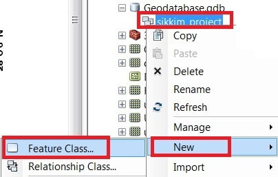
Select the Map Feature dataset (ex.-sikkim_project), click the right button of the mouse > select New > choose Feature Class.
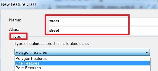
Type Name and Alias, select feature Type.
The database storage configuration wizard, do not make any changes just click the Next button.
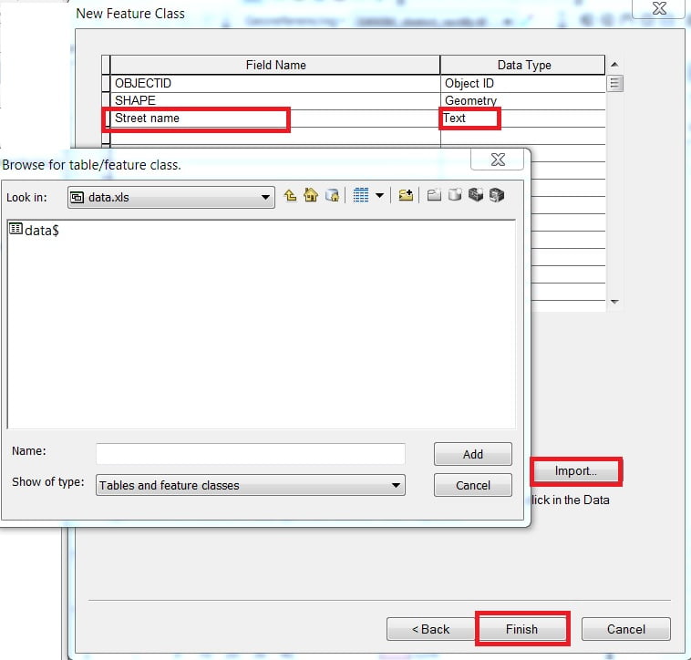
In the fields creation wizard, add new Field and select type in the field blank row.
You can also import data to click the Import button. Click the Finish button.
Feature Class vs Shapefile
- Shapefiles have many limitations compared to feature classes in a geodatabase.
- Shapefile attributes cannot store null values; they round up numbers.
- They do not allow field names longer than 10 characters, and they cannot store both a date and time in a field.
- Feature class support geodatabases function, but Shapefile do not support capabilities found in geodatabases such as domains and subtypes.
- The name of the output shapefile will be the name of the input feature class.