Layers in ArcGIS
Table of Contents
What is Layer
Layer is a dataset to specifies, how that dataset is portrayed using symbols and text labels.
Layers are used to display geographic datasets in ArcMap, ArcGlobe, and ArcScene. When you add a layer to a map, you specify its dataset and set its map symbols and labeling properties.
Types of Layers
There are many different types of layers that are represented in ArcGIS Pro
- Feature layers
- Raster layers
- Basemap layers
- Geoprocessing layers
- Scene layers
- Service layers
ArcGIS Map Layers
In ArcGIS, layer are collections of geographic data. Layers are displayed in a particular order displayed in the map’s Table of Contents.
A map layer defines how a GIS dataset is symbolized and labeled in map views.
Create New Layer in ArcMap
When you create a new layer by adding a dataset, the layer will draw using a default set of drawing properties.
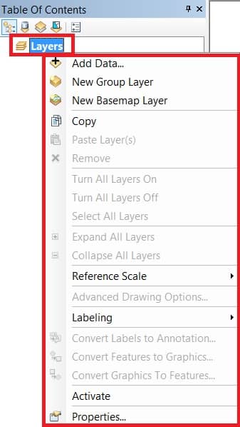
In ArcMap, on the Table of Contents section showing the Layers group.
In the Layers section, Add your Data, create New Group Layer, New Basemap Layer, and manage Data Frame Properties on the Properties section.
All are Data you can manage in the Layers section.
Layer Properties
Layers have a number of properties that you can work with and manage.
Right click a data layer (ex.-supervised_cultivatiion) in the table of contents and click Properties to appear the Layer Properties dialog box.
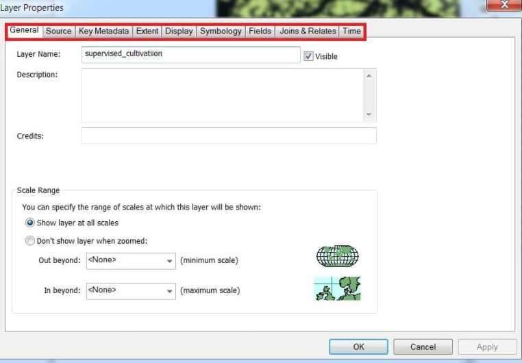
The Layer Properties section you set symbology, labeling, drawing rules, join and many other options.
Layer Attributes
Right-click a Layer and click Open Attribute Table. In the Table window, you can perform queries, make selections, locate features on the map, and so on.
ArcGIS Online Layers
In ArcGIS Online, Layers also called web layers, are logical collections of geographic data that are used to create maps and scenes.
Types of web layers
Create Layer in ArcGIS Online
To get started adding layers, sign in to ArcGIS Online, open Map Viewer Classic, and click the Add button.
Feature Layers
Feature layers are most appropriate for visualizing data on top of Basemaps. Features can be points, lines, or polygons (areas).
Using a feature layer, you can view, edit, analyze, and execute queries against features and their attributes.