Create Topology in GIS
In this Tutorial discussion about how to create Topology in ArcGIS.
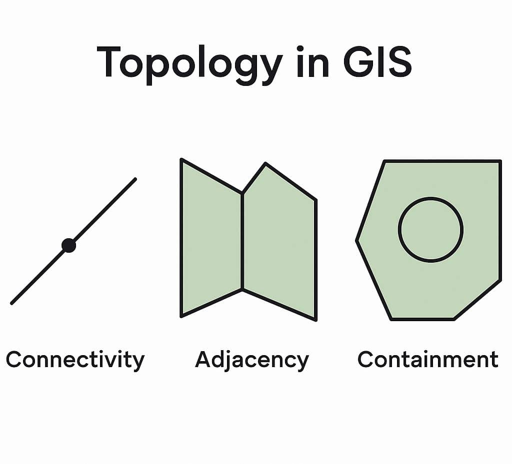
The spatial relationships between features in a vector layer are defined using topology. In topological Vector data, a mathematical procedure is used to define connections between features, identify adjacent polygons, and define a feature as a set of other features.
What is Topology?
Topology is a collection of rules that, coupled with a set of editing tools and techniques, enables the Geodatabase to more accurately model geometric relationships.
In Geodatabases, topology is the arrangement that defines how point, line, and polygon features share coincident geometry.
Topology is not automatically created when a vector layer is created. It must be added later using specific functions. Topology must be updated after a layer is edited also.
Create a Topology in ArcMap
- Right-click the Feature Dataset to which you want to add a topology, Point to New, then click Topology.
- Click Next.
- Name the new Topology and specify the Cluster tolerance. (The default value will be set to the x,y tolerance of the feature dataset). A good default value is 0.001 meters or its equivalent in the units of your spatial reference (for example, 0.003281 feet if your units are in feet or 0.0000000556 degrees if your units are in latitude-longitude as decimal degrees).
- Click Next.
- Next, choose the Feature Classes that will participate in the Topology. You will be shown a list of all the feature classes in your Feature Dataset.
- Click Next.
- Set the Coordinate Accuracy ranks for each feature class in the topology.
If one or more of your feature classes contain coordinate z-values, click Z Properties to set the z-ranks. The z-tolerance is used to distinguish the z-height, or elevation of vertices within the tolerance of one another. For example, two adjacent features of different heights might share a common edge between them. However, only their x,y vertices are colocated, not their z-value or height. The z-tolerance helps process this information correctly during validation and clustering operations. The default z-tolerance value is the same default value as the x,y tolerance (0.001 meter in real-world units
- Click Next.
- Add the series of topology rules that help you structure the spatial relationships between features and to control and validate how features share Geometry.
- Click Next.
- Review the Summary and click Finish. You have now added the new topology to your feature dataset. You will be asked if you would like to validate your topology in your feature dataset now. If you have data in your feature classes, you can choose Yes.
Topology Toolset
Tool | Description |
|---|---|
Add Feature Class To Topology | Adds a feature class to a topology. |
Add Rule To Topology | Adds a new rule to a topology. |
Create Topology | Creates a topology. The topology will not contain any feature classes or rules. |
Export Topology Errors | Exports the errors from a geodatabase topology to the target geodatabase. All information associated with the errors and exceptions, such as the features referenced by the error or exception, are exported. Once they are exported, the feature classes can be accessed using any license level of ArcGIS. The feature classes can be used with the Select by Location dialog box or the Select Layer By Location tool and can be shared with other users who do not have access to the topology itself. |
Remove Feature Class From Topology | Removes a feature class from a topology. |
Remove Rule From Topology | Removes a rule from a topology. |
Set Cluster Tolerance | Sets the cluster tolerance of a topology. |
Validate Topology | Validates a geodatabase topology. |