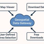
Open GIS Data
GIS Open Data is a type of open source Geographic information data, that you can freely download. Many sources are available to download open source data. You can access or download cultural, Natural Earth (Raster & Vector) Country data.
Open data capabilities come included in ArcGIS Online, no additional purchases or training are needed. You’ll be able to successfully share the data that you’re already collecting, maintaining, and curating using workflows and best practices.
Popular Sources of Open GIS Data
In the below, list of Open GIS Data sources
- ArcGIS Hub
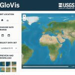
- Earth Explorer – USGS
- Bhuvan Indian Geo-Platform of ISRO
- Open Topography
- NEO (NASA Earth Observations)
- NASA Earthdata
- SEDAC – NASA
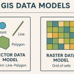
GIS Information vs Data
Information, as opposed to data, is independently meaningful. It is relevant to a particular problem or question:
- The land cover at coordinate N875250, E757261 has a data file value 8, is data.
- Land cover with a value of 8 are on slopes too steep for development, is information.
You can input data into a GIS and output information. The information you wish to derive determines the type of data that must be input. For example, if you are looking for a suitable refuge for bald eagles, zip code data is probably not needed, while land cover data may be useful.
Successful GIS implementation typically includes two major steps:
- Data input
- Analysis
Data input involves collecting the necessary data layers into a GIS database. In the analysis phase, these data layers are combined and manipulated in order to create new layers and to extract meaningful information from them.