GISRSStudy » GIS » GeoTIFF Data

GeoTIFF

What is a GeoTIFF?

The GeoTIFF stands for Geographic Tagged Image File Format. It was initially developed during the 1990s. Geographic TIFF is a format extension for storing Georeference and Geocoding information in a TIFF format. It can store a broad range of geo-referencing information, as well as projected coordinate systems. Supported projections include UTM, US State Plane and National Grid, as well as the underlying projection types, such as Transverse Mercator, Lambert Conformal Conic, etc.

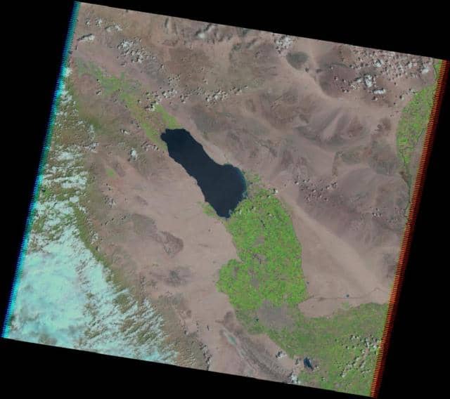
Geographic TIFF uses 32-bit offsets, limiting its extent to 4 gigabytes. The Geographic TIFF format embeds geospatial metadata into image files such as Aerial photography, Satellite imagery, and digitized maps so that they can be used in GIS Applications.

‍Download GeoTIFF File
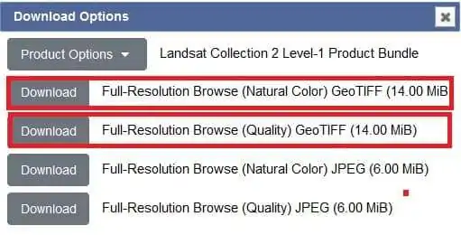
Many sources are available for ‍Download TIFF File, like USGS Earth Explorer, Bhuvan NRSC, ESA, and more.

How to Download Geo-TIFF File in Earth Explorer?

Download TIFF file, and use GIS Softwares for different purpose.

GeoTIFF Image

GeoTIFF Metadata

Data Set AttributeAttribute Value
Landsat Product Identifier L1LT05_L1TP_039037_20120426_20200820_02_T1
Landsat Scene IdentifierLT50390372012117EDC00
Date Acquired2012/04/26
Collection CategoryT1
Collection Number2
Sensor ModeBUMPER
WRS Path039
WRS Row037
Full Partial SceneFULL
Date Product Generated L12020/08/20
Start Time2012-04-26 18:00:27.89638
Stop Time2012-04-26 18:00:54.50919
Station IdentifierEDC
Day/Night IndicatorDAY
Ground Control Points Model757
Land Cloud Cover16.00
Scene Cloud Cover L116.00
Ground Control Points Version5
Geometric RMSE Model3.969
Geometric RMSE Model X2.621
Geometric RMSE Model Y2.981
Sensor AnomaliesNONE
Data Anomaly
Image Quality9
Gain ChangeN
Processing Software VersionLPGS_15.3.1c
Sun Elevation L160.15620766
Sun Azimuth L1124.53051647
Data Type L1TM_L1TP
Sensor IdentifierTM
Satellite5
Ephemeris TypeDEFINITIVE
Reflective Lines7031
Reflective Samples7911
Thermal Lines7031
Thermal Samples7911
Product Map Projection L1UTM
UTM Zone11
DatumWGS84
EllipsoidWGS84
Grid Cell Size Reflective30.00
Grid Cell Size Thermal30.00
Calibration Parameter FileLT05CPF_20120401_20120630_02.01
Scene Center Lat DMS33°11’44.56″N
Scene Center Long DMS115°42’51.95″W
Corner Upper Left Lat DMS34°07’32.20″N
Corner Upper Left Long DMS116°28’58.30″W
Corner Upper Right Lat DMS33°50’19.18″N
Corner Upper Right Long DMS114°30’38.56″W
Corner Lower Left Lat DMS32°32’32.17″N
Corner Lower Left Long DMS116°54’05.15″W
Corner Lower Right Lat DMS32°15’37.12″N
Corner Lower Right Long DMS114°57’47.52″W
Scene Center Latitude33.19571
Scene Center Longitude-115.71443
Corner Upper Left Latitude34.12561
Corner Upper Left Longitude-116.48286
Corner Upper Right Latitude33.83866
Corner Upper Right Longitude-114.51071
Corner Lower Left Latitude32.54227
Corner Lower Left Longitude-116.90143
Corner Lower Right Latitude32.26031
Corner Lower Right Longitude-114.96320

How to Use GeoTIFF Data

How to Use TIFF File in Erdas Imagine Software?

Open GeoTIFF image in Erdas Imagine Software. Now you can perform multiple tasks, like Spatial Analysis, create Thematic map, Land use survey, and more.

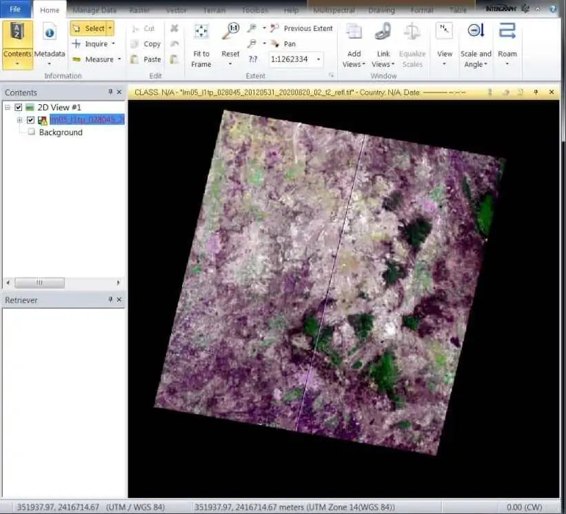
Some Example in below:
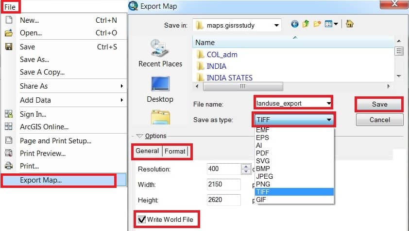
Export Raster to GeoTIFF format in ArcMap

  1. In ArcMap, on the main menu, click File > Export Map.
  2. The Export Map dialog box appears, choose TIFF from the Save as type drop-down list.
  3. In the Options section, General tab, check Write World File.
  4. On the Format tab, check Write GeoTIFF Tags and click Save button.

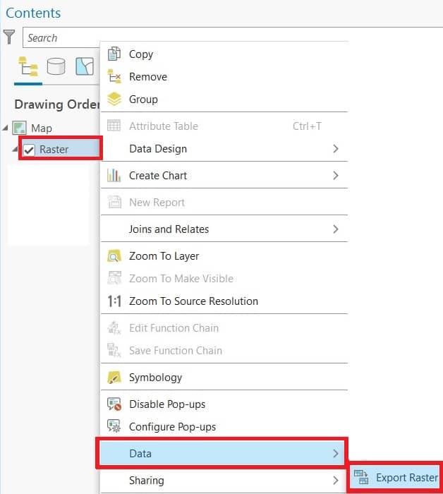
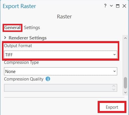
Export GeoTIFF in ArcGIS Pro

  1. In ArcGIS Pro, Right-click the raster from the Contents pane.
  2. Point to Data > Export Raster.
  3. In the Export Raster pane, select the options with the parameters desired, ensure Output Format is set in TIFF.
  4. Click Export.

Leave a Comment

Your email address will not be published. Required fields are marked *

Scroll to Top