Types of GIS Data
GIS Data Types
GIS (Geographic Information System) data can be broadly classified into three main types, each with its own subtypes:
- Spatial Data
- Attribute Data
- Metadata

Spatial Data (Geospatial Data)
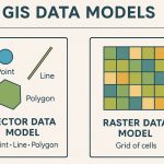
There are two different types of Spatial data, I) Vector data and II) Raster data. Each type of data has its own format.
Vector Data
Vector Data is simply XY coordinates. Generally, they are a Latitude and Longitude value. The Vector data represents are Points, Lines, and Polygons.
Point Data
A point is represented by a single x, y coordinate pair. Points can represent the location of a geographic feature or a point that has no area, such as a mountain peak, hotel, school, bank, etc.
Line/ Polyline Data
A Line or polyline is a set of line segments and represents a linear geographic feature, such as a river, road, or utility line. Lines can also represent non-geographical boundaries.
Polygon Data
A polygon defining a homogeneous area, such as land use, water body, boundary, etc. Polygons can also be used to represent non-geographical features, such as wildlife habitats, state borders,commercial districts, and so on.
Raster Data
Raster Data also known as grid data, for e.g.- elevation, slope, population, etc. A Raster Data are Digital Aerial Photographs, Satellites imagery, Digital pictures, or even scanned Maps.
The Raster data represents two types of data, Continuous and Discrete.
Continuous Data
A Continuous data represents phenomena in which each location on the surface is a measure of the concentration level or its relationship from a fixed point in space or from an emitting source. Continuous data is also referred to as field, non-discrete, or surface data. Sea level is a continuous object.
Discrete Data
A Discrete data, which is sometimes called thematic, categorical, or dis-continuous data, most often represents objects in both the vector and raster data storage systems. It is easy to define precisely where the object begins and where it ends. A lake is a discrete object within the surrounding landscape. Other examples of discrete objects are; buildings, roads, and parcels.
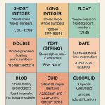
Attribute Data
Attribute information is displayed in Cell Arrays. Along with points, lines, and polygons, a vector layer can have a wealth of associated descriptive, or attribute information associated with it.
Some attributes are automatically generated when the layer is created. Custom fields can be added to each Attribute table. Attribute fields can contain numerical or character data.
Metadata
Metadata is basically textual data that describes data. It often includes elements such as data creation date, history of the data, data type, and common usages of the data.
A Metadata can help users know what’s in your services, who created them, and what usage restrictions they might carry. Some organizations require specific items of metadata on any geographic information they publish.
Summary
| GIS Data Type | Description | Example |
|---|---|---|
| Vector (Spatial) | Points, lines, polygons (discrete) | Roads, rivers, buildings |
| Raster (Spatial) | Grid cells with values (continuous) | Land cover, elevation, temperature |
| Attribute | Descriptive info in tables | Population of cities, land use type |
| Metadata | Data about data | Source, projection, update date |