ArcGIS Data Interoperability
Table of Contents
What is ArcGIS Data Interoperability?
The ArcGIS Data Interoperability is a simple solution for complex integrations. Design data movement among hundreds of systems and apps using a visual programming interface.
Features
- Simple solution for complex integrations
- The no-code transformation
- Delivers geospatial integration to all systems
- Access hundreds of non-native datasets
Data Interoperability Extension
The Data Interoperability extension for Desktop is an integrated spatial extract, transform, and load toolset that runs within the geoprocessing framework using Safe Software’s Feature Manipulation Engine (FME) technology. Use that data with geoprocessing tools, and publish it with ArcGIS Server.
ArcGIS Desktop Data Interoperability
The Data Interoperability extension for Desktop is offered two licensing levels:
- Installing the Data Interoperability, immediate access to WFS and GML-SF (simple features) datasets. You can use conversion tools in the Data Interoperability toolbox to read WFS services, and read and write GML-SF datasets.
- Authorizing and enabling Data Interoperability with a valid license in the Desktop application adds additional support for over 100 GIS, CAD, Raster, and database formats.
ArcGIS Server Data Interoperability
The Data Interoperability extension for Server enables you to publish map and data services that contain interoperability data formats to you have authorize in ArcGIS Desktop as geoprocessing services.
ArcGIS Engine Data Interoperability
The Data Interoperability extension for ArcGIS Engine for Windows enables developers to embed the extension’s tools for Quick Import, Quick Export, and Spatial ETL in custom desktop applications.
Data Interoperability Tutotial in ArcMap
Enabling Data Interoperability
Start ArcMap, in the main menu, click Customize > Extensions, then check Data Interoperability.
Data Interoperability Toolbox
The Data Interoperability toolbox contains two tools that helps you to import and export data between geodatabase and non-native formats using FME readers and writers.
Open Data Interoperability toolbox, in ArcToolbox, there is Data Interoperability toolset, available two tools;
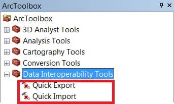
- Quick Import
- Quick Export
Quick Import
The Quick Import tool imports one or more external datasets into a geodatabase as feature classes. The input parameters include the data source and the FME reader and any parameters supported by the chosen format. The output staging geodatabase can be used directly or for further processing.
Quick Export
The Quick Export tool exports one or more geodatabase feature classes or feature layers to an external dataset. The input parameters include the data source and the FME writer and any parameters supported by the chosen format.