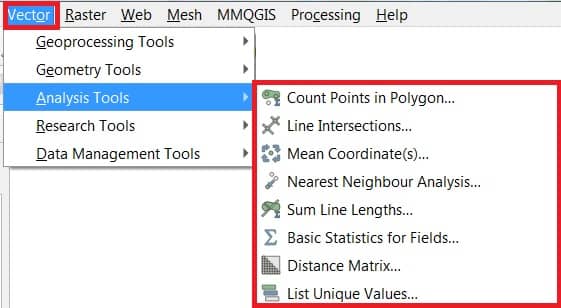
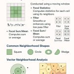
In the Toolbar menu, click on Vector, selectAnalysis Tools, and see all the available Analysis Tools.
Sl No.
Tool
Purpose
1
Count Points in polygon
Count the number of points that occur in each polygon of an input polygon vector layer.
2
Line intersections
Locate intersections between lines, and output results as a point shapefile. Useful for locating road or stream intersections, ignores line intersections with length > 0.
3
Mean coordinate(s)
Compute either the normal or weighted mean center of an entire vector layer, or multiple features based on a unique ID field.
4
Nearest neighbor analysis
Compute nearest neighbor statistics to assess the level of clustering in a point vector layer.
5
Sum line length
Calculate the total sum of line lengths for each polygon of a polygon vector layer.
6
Basic statistics for numeric field
Compute basic statistics (mean, std dev, N, sum, CV) on an input field.
7
Distance matrix
Measure distances between two point layers, and output results as: i) Square distance matrix, ii) Linear distance matrix, or iii) Summary of distances. Can limit distances to the k nearest features.
8
List unique values
The List all unique values in an input vector layer field.