Analysis Tools: ArcGIS
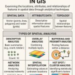
The ArcGIS Analysis toolbox contains a powerful set of tools that perform the most fundamental GIS operations. You can perform overlays, create extract, calculate statistics, and proximity analysis.
The Analysis toolbox has four toolsets. Each toolset performs specific GIS analysis of feature data.
Analysis Toolset & Tools
| Toolsets | Description |
|---|---|
| Extract | The Extract tools let you select features and attributes in a feature class or table based on a query or spatial extraction. The output features and attributes are stored in a feature class or table. |
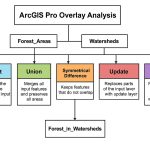
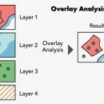
| Overlay | The Overlay toolset contains tools to overlay multiple feature classes to combine, erase, modify, or update spatial features, resulting in a new feature class. New information is created when overlaying one set of features with another. |
| Proximity | The Proximity tools contains tools that are used to determine the proximity of features within one or more feature classes or between two feature classes. These tools can identify features that are closest to one another. |
| Statistics | The Statistics tools contains tools that perform standard statistical analysis on attribute data as well as tools that calculate area, length, and count statistics for overlapping and neighboring features. |
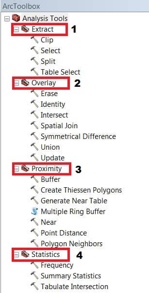
Extract Tool
Four types of extraction options available in ArcGIS;
Overlay Tool
There are seven types of overlay operations; all involve joining two existing sets of features into a single set of features to identify spatial relationships between the input features.
Proximity Tool
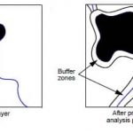
Proximity analysis determines which pixels of a layer are located at specified distances from pixels in a certain class or classes. There are seven types of proximity tools;
- Buffer
- Create Thiessen Polygons
- Generate Near Table
- Multiple Ring Buffer
- Near
- Point Distance
- Polygon Neighbors
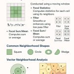
Statistics Tool
The Statistics toolset contains three tools that perform standard statistical analysis, such as mean, minimum, maximum, and standard deviation.
Analysis Toolbox Licensing
| Toolset/Tool | Basic | Standard | Advanced |
| Extract Toolset | |||
| Clip | ✔ | ✔ | ✔ |
| Select | ✔ | ✔ | ✔ |
| Split | ✔ | ||
| Table Select | ✔ | ✔ | ✔ |
| Overlay Toolset | |||
| Erase | ✔ | ||
| Identity | ✔ | ||
| Intersect (Some parameters are limited by license level – see the tool reference page for more detail). | ▢ | ▢ | ✔ |
| Spatial Join | ✔ | ✔ | ✔ |
| Symmetrical Difference | ✔ | ||
| Union (Some parameters are limited by license level – see the tool reference page for more detail). | ▢ | ▢ | ✔ |
| Update | ✔ | ||
| Proximity Toolset | |||
| Buffer (Some parameters are limited by license level – see the tool reference page for more detail). | ▢ | ▢ | ✔ |
| Create Thiessen Polygons | ✔ | ||
| Generate Near Table | ✔ | ||
| Multiple Ring Buffer | ✔ | ✔ | ✔ |
| Near | ✔ | ||
| Polygon Neighbors | ✔ | ✔ | ✔ |
| Statistics Toolset | |||
| Frequency | ✔ | ||
| Tabulate_Intersection | ✔ | ||
| Summary Statistics | ✔ | ✔ | ✔ |
✔– this symbol incicate to – full license level.
▢– this symbol indicate to – limited by license level.
ArcGIS Pro Analysis Tools
In the ArcGIS Pro Analysis tools, you can perform overlays, create buffers, calculate statistics, perform proximity analysis, and much more.
| Toolsets | Description |
|---|---|
| Extract | The Extract tools let you select features and attributes in a feature class or table based on a query (SQL expression) or spatial and attribute extraction. |
| Overlay | The Overlay toolset new information is created when overlaying one set of features with another. All of the overlay operations involve joining two sets of features into a single set of features to identify spatial relationships between the input features. |
| Pairwise Overlay | The Pairwise Overlay toolset contains tools that provide an alternative to a number of classic overlay tools for functional and performance considerations. |
| Proximity | The Proximity toolset contains tools that are used to determine the proximity of features within one or more feature classes or between two feature classes. |
| Statistics | The Statistics tool-set also includes the Enrich tool that adds demographic facts like population or landscape facts like percent forested to your data. |