Summary: –
Remote Sensing Process involves capturing data from a distance, processing and analyzing that data, and applying the results to various applications that help in decision-making and resource management.
The Complete Remote Sensing Process Explained: From Sensors to Insights
In Remote Sensing (RS), the process involves an interaction between radiation and the targets of interest. There are following eight elements are involved in RS process.
List of Remote Sensing Processes
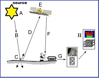
- Energy Source (A)
- Radiation and the Atmosphere (B)
- Interaction with the Target (C)
- Recording of Energy by the Sensor (D)
- Transmission and Reception (E)
- Data Processing (F)
- Interpretation and Analysis (G)
- Application (H)
Energy Source
The first requirement for remote sensing is to have an energy source which illuminates or provides electromagnetic energy to the target of interest.
Emission of Electromagnetic radiation. (The Sun or an EMR source located on the platform)
Radiation and the Atmosphere
After they have scattered the energy by, emitted from the target, we require a sensor to collect and record the electromagnetic radiation.
The Transmission of energy from the source to the object (Absorption and scattering of the EMR while transmission).
Interaction with the Target
Once the energy makes its way to the target through the atmosphere, it interacts with the target depending on the properties of both the target and radiation.
Interaction of EMR with the object and subsequent reflection and emission.
Recording of Energy by the Sensor
After the energy has been scattered by, emitted from the target, we require a sensors to collect and record the electromagnetic radiation.
Recording of energy by the sensor. (Photographic or non-photographic sensors).
Transmission and Reception
The energy required by the sensors has to be transmitted, often in electronic form, to receive and processing section.
Transmission of energy from the object to the sensor, and recorded information to the ground station.
Data Processing
The Sensors have received the data, and processing section where the data are produced into an image.
Processing of the data into digital or hard copy image
Interpretation and Analysis
The proceed image is interpreted in two types visually and digitally.
Analysis of the data in GIS or Remote Sensing softwares.
Application
Finally, apply the information you have been able to extract from the imagery about the target in order to better understand it.