IRNSS- Indian Regional Navigation Satellite System
Introduction
IRNSS stand for Indian Regional Navigation Satellite System, it’s developed by ISRO (Indian Space Research Organisation) to provide accurate position information service to users in India and surrounding regions.
IRNSS designed for accurate position information for India service. It is providing two types of services, i) Standard Positioning Service (SPS), ii) Restricted Service (RS).
- Standard Positioning Service– provided to all the users.
- Restricted Service– provided only to the authorized users.
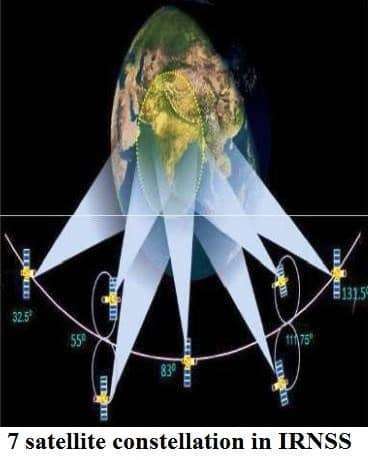
The Indian Regional Navigation Satellite System constellation made up of a combination of Geostationary Earth Orbit (GEO) and Geo-synchronous Orbit (GSO) spacecraft over the Indian region. The IRNSS constellation will consist of 7 Satellites – 3 in GEO orbit, at 34º E, 83º E and 131.5º E, and 4 in GSO orbit inclined at 29 degrees to the equatorial plane with their longitude crossings at 55º E and 111.5º E.
Features
- 7 satellite constellation and ground segment
- Coverage area is about 1500 km beyond Indian territory
- Estimated horizontal position accuracy of 20m in over India and adjoining areas
Applications
- Mapping and Geodetic data capture
- Aerial and Marine Navigation
- Integration with mobile phones
- Terrestrial Navigation
- Disaster Management
- Precise Timing
India Navigation Satellite System Segments
3 Segments of Indian Regional Navigation Satellite System
Space Segment
- The first Satellite launched on 1st July 2013
- The full constellation will be realized by the end of 2015
- Consists of 7 Satellites, 3 in Geo-Stationary orbit at 32.5°, 83°and 131.5°East
- 4 Satellites in GEO Synchronous orbit at inclination of 29° with Longitude crossing at 55°and 111.75°East
- IRNSS Satellites are to be launched by the Indian launcher PSLV
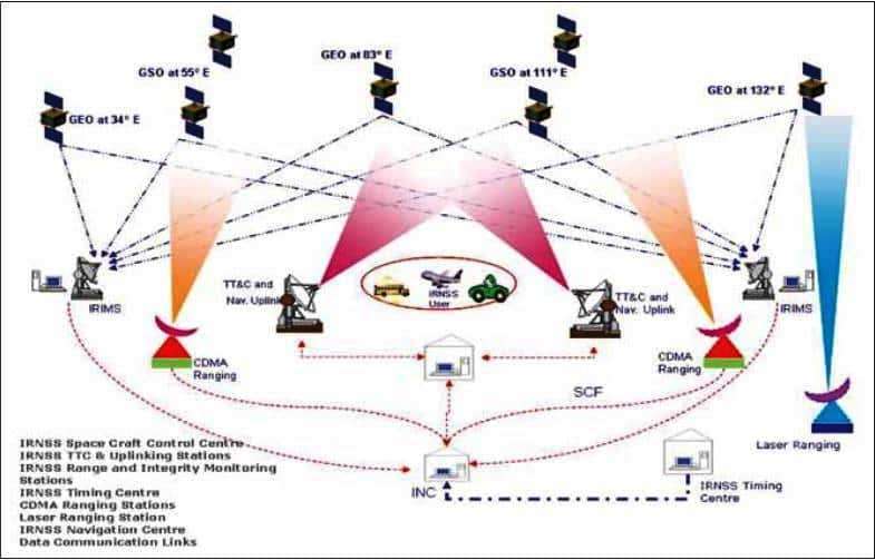
Ground Segment
Ground segment includes the major systems for controlling the satellite constellation and will consist-
- Spacecraft Control Facility (SCF)
- IRNSS Navigation Center (INC)
- Range and integrity monitoring stations (IRIMS)
- CDMA Ranging Stations (IRCDR)
- Network Timing Facility (IRNWT)
- Data Communication Network (IRDCN)
User Segment
The user segment consists of Indian Regional Navigation Satellite System receivers operating-
- Single Frequency ( L5 or S band)
- Dual Frequency (L5 and S band)