ILWIS- Integrated Land and Water Information System
What is ILWIS?
ILWIS stands for Integrated Land and Water Information System. It is a PC-based open source software GIS & Remote Sensing software, developed by ITC.
ILWIS desktop application allows for image processing, spatial analysis, and digital mapping. Also, it is easy to learn and use.
Features:
- Integrated raster and vector design
- Import and export of widely used data formats
- On-screen and tablet digitizing
- Comprehensive set of image processing tools
- Ortho photo, image georeferencing, transformation and mosaicing
- 3D visualization with interactive editing for optimal view findings
- Geo-statistical analyses, with Kriging for improved interpolation
- Production and visualization of stereo image pairs
- Advanced modeling and spatial data analysis
- Spatial Multiple Criteria Evaluation
- Set of operations on DEMs/DTMs and hydrological processing
Download ILWIS Software
As per 1st July, 2007, ILWIS software is freely available, under the 52°North initiative (GPL license). This software version is called ILWIS 3.4 Open.
Download the ILWIS 3.3Academic.exe in below.
When the file has been downloaded, start the installation by double-clicking it. The installation files will be unpacked, then the installation is automatically started.
Tutorial
To start ILWIS, double-click the ILWIS icon on the desktop.
- Manu bar
- Standard Toolbar
- Object selection Toolbar
- Command line
- Operation/Navigator pane
- Catalog
- Map view
- Status bar
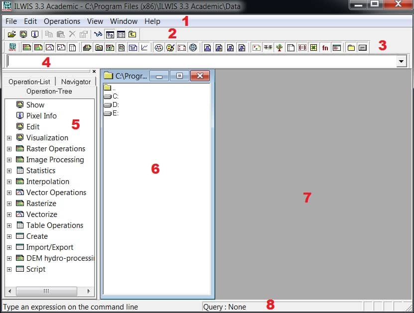
Menu bar:
The Menu bar can be used to start an operation, to create or edit objects, to view the properties of an object, etc.
Standard Toolbar:
The Standard toolbar provides shortcuts for regularly used menu commands such as Customize Catalog, List/Details View, etc.
Object selection Toolbar:
The Object selection toolbar can be used to select the object types that should be visible in the currently active Catalog.
Command line:
The Command line is mainly used to type calculations (MapCalc) and expressions (perform operations).
Operation-tree and Operation-list:
The Operation-tree provides a tree structure for all operations, similar to the Operations menu.
The Operation-list contains an alphabetic list of all operations. Each operation is preceded by an icon; the icon indicates the output data type of the operation.
Navigator:
You can use the Navigator to change the current drive and working directory. Click the word Navigator in the Operations/Navigator pane
The Navigator lists all drives and directories (folders) in a tree structure. It also has a History to easily return to previously visited drives and directories.
Click on the drives and folders in the Navigator until you are in the directory where the data for these exercises has been stored.
Catalog:
This part of the Main window, in which maps, tables and other objects in the working directory are displayed, each with its own type of icon, is called the Catalog. When you double-click an object in the Catalog, it will be displayed.
Map view:
The Map viewer helps you to show all the data maps, chart, layout.
Status bar:
The Status bar gives short information on the item on which the mouse pointer is located: a menu command, a button in the toolbar, an object in the Catalog, an operation in the Operation-list or the Operation-tree, etc.
very good post, i definitely love this web site, carry on it