Spatial Analysis in GIS: ArcGIS
What is Spatial Analysis?
Spatial analysis is the process of using geographic data to solve real-world problems by analyzing locations, attributes, distances, and patterns.
Spatial Analysis in Geographic Information Systems (GIS) involves evaluating spatial relationships, patterns, and trends using geospatial data. It helps in decision-making, modeling, and prediction by answering where, how much, why, and what if questions.
The first time you look at a map, you analyze the features and relationships presented. You naturally begin compiling various types of information by identifying patterns, determining trends, or making decisions through the analysis. This natural process of looking at and analyzing a map is spatial analysis.
Core Elements
| Element | Description |
|---|---|
| Location | Where things are located (coordinates, addresses, etc.) |
| Distance | How far things are from each other (buffer, proximity) |
| Pattern | Distribution (random, clustered, dispersed) |
| Topology | Spatial relationships (adjacency, connectivity, overlap) |
| Change over time | Temporal trends in spatial data |
Benefits
Spatial analysis helps you to understand where things are, understand how they relate, and understand what actions to take.
Through the use of spatial analysis, the county can better protect its citizens from health concerns and improve the outcome of the flu outbreak.
Using spatial analysis, they have determined that adding a new warehouse and splitting the town into two service areas will allow them to meet the two-hour delivery window.
It’s also helps the office supply store reduce costs, increase efficiency and productivity, and improve customer service.
Categories
Spatial analysis questions can be placed into 6 categories:
- Understand where?
- Measure size, shape, and distribution
- Determine how places are related
- Find the best locations and paths
- Detect and quantify patterns
- Make predictions
Types of Spatial Analysis in GIS
| Type | Function/Use | Example |
|---|---|---|
| Descriptive Analysis | Counts, summaries, area, length | Count number of schools in a city |
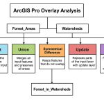
| Overlay Analysis | Combines layers to find spatial relationships | Land use + flood zone overlay |
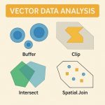
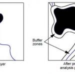
| Buffering and Proximity | Analyzes areas within a specific distance | Find wells within 1 km of a landfill |
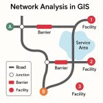
| Network Analysis | Routes, service areas, shortest path | Best route for emergency vehicles |
| Spatial Interpolation | Predict unknown values using known data | Estimate rainfall in unsampled areas |
| Hot Spot/Cluster Analysis | Identifies spatial clustering or concentration | Detect crime hotspots |
| Terrain and Surface Analysis | Uses elevation or slope data | Find suitable slope for farming |
| Temporal Analysis | Tracks spatial change over time | Monitor urban expansion from 2000–2025 |

Tools for Spatial Analysis
There are several free and license based tools/ applications available to perform Geo-spatial analysis.
ArcGIS Spatial Analysis
The ArcGIS Spatial Analyst extension provides a set of spatial analysis and modeling tools for both Raster and Vector data.
The ArcGIS Spatial Analyst extension has over 170 Tools in 23 Tool sets for performing Spatial Analysis in GIS.
Using spatial analysis in ArcGIS, you can perform the following types of operations on geographic data:
- Extract and overlay data.
- Add and calculate attribute fields.
- Summarize and aggregate data.
- Calculate statistics.
- Model relationships and discover patterns.
Extensions
ArcGIS includes the following analysis extensions to help your spatial queries:
- 3D Analyst—Create 3D GIS data and perform 3D surface operations using raster, TINs, terrains, and LiDAR datasets.
- Business Analyst—Analyze market trends, including customer and competitor analysis, site evaluation, and territory planning.
- Geostatistical Analyst—Analyze and predict the values associated with spatial or spatio-temporal phenomena.
- Image Analyst—Perform feature extraction and measurement, and also classification and object detection using machine learning.
- Network Analyst—Measure distances and travel times along a network to find a route between multiple locations, create service areas, and find the best locations for facilities to serve a set of locations.
- Spatial Analyst—Perform interpolation, overlay, distance measurement, density, hydrology modeling, site suitability, math and statistics on cell-based raster data.
Example of Spatial Analysis
Surface Analysis is the example of Spatial Data Analysis in GIS.