GPS- Global Positioning System: How GPS Work
Introduction of GPS
The GPS stand for Global Positioning System, it is a satellite-based navigation system owned by the United States government and operated by the United States Space Force. It’s formed from a constellation of 24 satellites. GPS works in any weather conditions, anywhere in the world, 24 hours a day. In 1973 the U.S. Department of Defense (USDOD) decided to establish, develop, test, acquire, and deploy a spaceborne GPS. It’s originally put the satellites into orbit for military use, but they were made available for civilian use in the 1980s.

The Global Positioning System is one of the Global Navigation Satellite Systems (GNSS) that provides Geo-location and Time information to a GPS receiver anywhere on or near the Earth.
Principles of GPS
- The GPS System Consists of 24 Satellite that broadcast Signals containing information about their position and timing.
- A GPS receiver processes signal from at least 4 Satellites.
- GPS system and receiver is the constancy of the speed of light.
- Positions of satellites can be known from ephemeris data.
- Distances from the satellites are determined with the help of travel time of the signal from the satellite to the receiver.
Characteristics
- Accurate Navigation 10 – 20 m
- Worldwide Coverage
- 24 hour access
- Common Coordinate System
- 20,200 Km above the Earth
- Accessible by Civil and Military
Navigational Systems of GPS
GPS satellites broadcast different types of data in the primary navigation signal.
- Almanac – sends time and status information about the satellites.
- Ephemeris – has orbital information that allows the receiver to calculate the position of the satellite.
Satellites broadcast two forms of clock information
- Coarse / Acquisition code (C/A) – freely available to the public. The C/A code is a 1,023 bit long pseudo-random code broadcast at 1.023 MHz, repeating every millisecond.
- Restricted Precise code (P-code) – reserved for military usage. The P-code is a similar code broadcast at 10.23 MHz, but it repeats only once a week.
GPS in GIS
GIS and GPS activity, you will collect and use local data from ground observations and satellites as well as create and use your own set of GPS waypoints. After collecting and importing GPS data into My world GIS, you will categorize the field data to display the burial patterns in a local community’s cemetery during a period of the history of your choice.
Advantages
- Weather Independent
- Gives high Geodetic Accuracy
- Can be operated day and night
- Quicker and requires less manpower
- Economical advantages
- Common Coordinate System
- Wide Range of Applications
How Does GPS Work
The GPS satellites act as reference points from which receivers on the ground resects, their position, and a precise orbit. Each satellite transmits a unique signal and orbital parameters that allow GPS devices to decode and compute the precise location of the satellite. GPS receivers use this information and trilateration to calculate a user’s exact location. Essentially, the GPS receiver measures the distance to each satellite by the amount of time it takes to receive a transmitted signal.
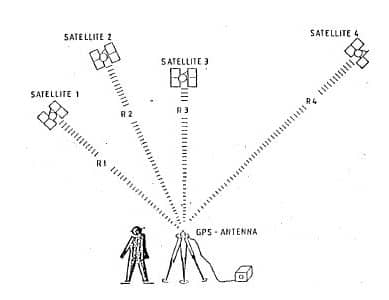
A GPS receiver must be locked on to the signal of at least 3 satellites. With 4 or more satellites in view, the receiver can determine your 3-D position. Generally, a GPS receiver will track 8 or more satellites. Once your position has been determined, the GPS unit can calculate other information, such as:
- Speed
- Bearing
- Track
- Trip distance
- Distance to destination
- Sunrise and sunset time, etc
- As each GPS satellite circles the earth, it transmits a radio signal called a pseudo random code.
- Each signal is encoded with information used to determine a receiver’s location.
- The signal transmission includes the time the signal was sent and the satellite’s location in space.
- Receivers on earth receive this signal.
- All the satellites in the constellation send their information at the same time.
- However, they arrive at different times due to the distance the signals travel.
- Formula: Distance = Speed x Time
- Signal travels at the speed of light – 186,282.3976 miles per second
- Speed and Time are known, use to calculate Distance
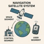
Understanding the GPS Framework (Segments of GPS)
At the heart of the GPS system are three segments:
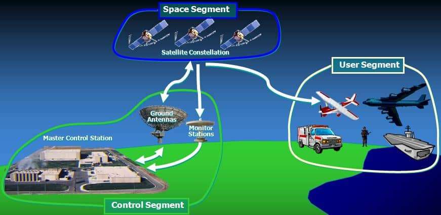
1. Space segment
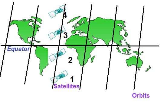
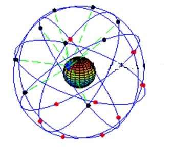
The Space segment is constellation of 24 to 32 satellites in precise, nearly circular orbits about 20,200 km above the earth. The satellites are arranged in six orbital planes. Each plane is tilted at 55 degrees relative to the equator, to provide polar coverage. Each satellite orbits the earth twice a day.
Characteristics
- 24 Satellites
- 4 satellites in 6 Orbital Planes inclined at 55 Degrees
- 20,200 Km above the Earth
- 12 Hourly orbits §In view for 4-5 hours
- Designed to last 7.5 years
- Different Classifications Block 1, 2, 2A, 2R & 2 F
2. Control segment
The Control Segment a Master Control Station (MCS), includes 12 ground stations. The monitor stations track the navigation signals from all the satellites and continuously send the data to the Master Control Station for processing. Every satellite is always in view of at least 2 ground stations and usually 3.
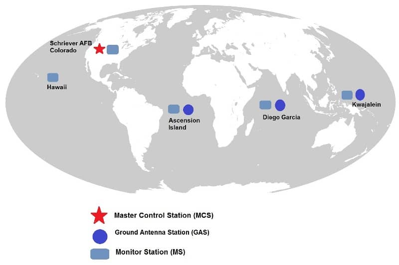
Characteristics
- Master Control Station
- 5 Monitoring Stations
- Ground Control Stations
3. User segment
The user segment is composed of hundreds of thousands of both military and civilian applications. GPS receivers are required to receive signal from GPS satellites for the purpose of navigation or positioning.
Characteristics
- The most visible segment
- GPS receivers
- Receive Satellite Signal
Errors of GPS
Atmospheric errors:
GPS signal passes through the charged particles of the ionosphere and then through the water vapor in the troposphere it gets slowed down.
Signal multi-path error:
The GPS signal is reflected off objects such as tall buildings or large rock surfaces before it reaches the receiver. This increases the travel time of the signal, thereby causing errors.
Satellite clock error:
The atomic clocks are not 100% perfect.
Very accurate clocks accumulate an error of 1 billionth of a second every three hours.
Satellites are continuously monitored by ground stations and compared with the master control clock systems that are combinations of more than 10 very accurate atomic clocks.
The errors of the satellites’ clock are calculated and included in the messages that are transmitted by the satellites.
In computing the distance to the satellites, GPS receivers subtract the satellite clock errors.
Even with the best efforts errors cannot be precisely determined always.
Receiver clock errors:
Receivers are not equipped with atomic clock
Making simultaneous measurements to four satellites, we can find the error in our receiver clock with very good accuracy.
Orbital/ephemeris errors:
Inaccuracies of the satellite’s reported location
The orbits of satellites are monitored continuously from several monitoring stations around the earth
Predicted orbital information is transmitted to the satellites, which they in turn transmit to the receivers
Satellites do not follow the exact predicted orbit because of gravitational pulls from the moon and sun and by the pressure of solar radiation on the satellites
This will create about a few meters of error
Number of satellites:
The more satellites the receiver can “see”, the better the accuracy.
Buildings, Terrain, electronic interference, dense vegetation canopy can block signal reception, causing position errors
GPS units not working indoors (typically), underwater, or underground. The receiver uses the satellite data to triangulate its position. More objects to reference our position confirm a more accurate positioning.
Satellite geometry:
Relative position of the satellites at any given time.
Ideal satellite geometry exists when the satellites are located at wide angles relative to each other.
Poor geometry results when the satellites are located in a line or in a tight grouping.
Also known as “Geometric Dilution of Precision” or GDOP.
Selective availability and anti-spoofing:
The U.S. military’s intentional degradation of the signal.
Intended to prevent from using the highly accurate GPS signals.
Degrade the positional accuracy about 100 meters.
SA can be turned ON or OFF through ground commands by the GPS system administrators.
SA was turned off May 2, 2000, and is currently not active.
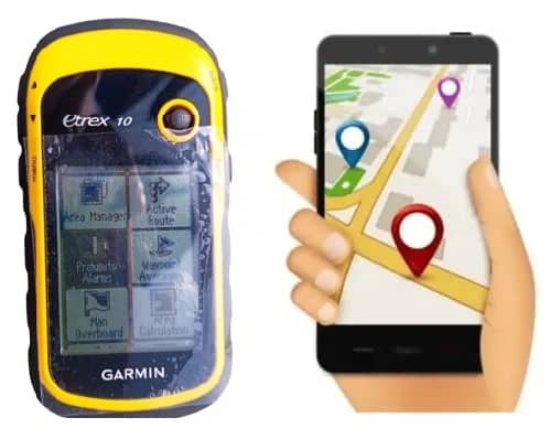
GPS Receiver
A receiver calculates its position by measuring how long it takes for the signals to arrive from multiple satellites and then solving a set of equations to determine its coordinates.
GPS receivers have a similar core operation:
■ collect the data broadcast by the satellites,
■ measure the signals, and
■ compute position, velocity, and time
Components of GPS receiver:
The main components of a GPS receiver are-
- Antenna with pre-amplifier
- RF section with signal identification and signal processing
- Micro-processor for receiver control, data sampling and data processing
- Precision oscillator
- Power supply
- User interface, command and display panel
- Memory, data storage
Classification of GPS receiver:
Classification of GPS receivers is based on acquisition of Data Types
- C/A code receiver
- C/A Code + L1 Carrier phase
- C/A Code + L1 Carrier phase + L2 Carrier phase
- C/A code + p_code + L1, L2 Carrier phase
- L1 Carrier phase
- L1, L2 Carrier phase
- L1, L2, L5 Code/Carrier phase
Classification of GPS receivers is based on Technical Realization
- Multi-channel receiver
- Sequential receiver
- Multiplexing receiver
Classification of GPS receivers is based on Purpose
- Military receiver
- Civilian receiver
- Navigation receiver
- Timing receiver
- Geodetic receiver
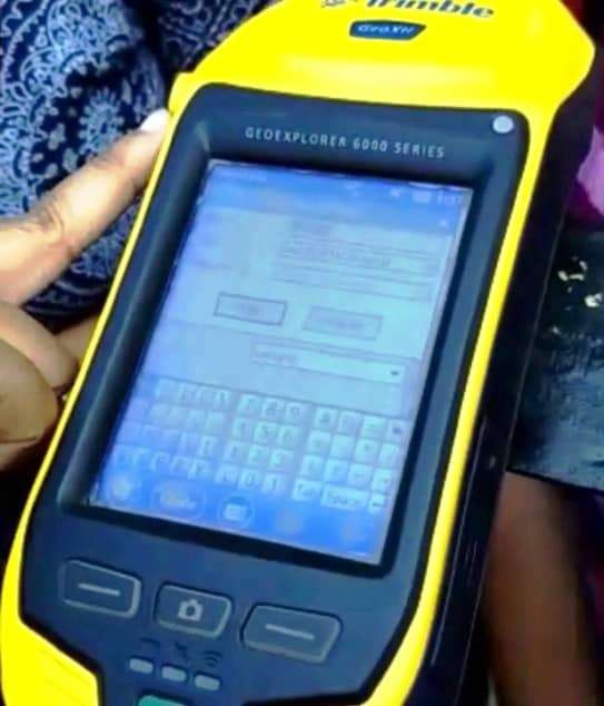
GPS Survey (Practical Example)
Field Book and Calculation Table of GPS Survey
| Sl No. | Waypoint | Easting (m east from 84°E) | Northing (m north from 0°) | Accuracy (m) | Distance from preceding waypoint (m) | Area Calculation |
|---|---|---|---|---|---|---|
| 1 | A | 640,467 | 2,491,907 | 19 | — | 58,783,042 |
| 2 | B | 640,465 | 2,491,991 | 17 | 273.84 | 341,670,604 |
| 3 | C | 640,396 | 2,492,256 | 14 | 89.49 | 124,216,828 |
| 4 | D | 640,368 | 2,492,341 | 15 | 252.60 | 278,443,632 |
| 5 | E | 640,320 | 2,492,589 | 13 | 123.63 | 316,902,258 |
| 6 | F | 640,198 | 2,492,609 | 10 | 137.03 | 352,643,531 |
| 7 | G | 640,065 | 2,492,642 | 9 | 84.10 | 212,483,132 |
| 8 | H | 639,989 | 2,492,678 | 10 | 171.21 | 386,463,463 |
| 9 | I | 639,864 | 2,492,795 | 17 | 125.26 | 306,480,463 |
| 10 | J | 639,739 | 2,492,787 | 9 | 124.34 | 288,766,278 |
| 11 | K | 639,617 | 2,492,763 | 11 | 39.29 | 101,121,164 |
| 12 | L | 639,579 | 2,492,773 | 14 | 101.02 | 32,112,175 |
| 13 | M | 639,542 | 2,492,679 | 11 | 119.00 | -78,598,177 |
| 14 | N | 639,543 | 2,492,560 | 8 | 193.04 | -72,941,056 |
| 15 | O | 639,523 | 2,492,368 | 8 | 169.65 | -18,927,938 |
| 16 | P | 639,488 | 2,492,202 | 10 | 190.39 | -6,156,190 |
| 17 | Q | 639,443 | 2,492,017 | 14 | 341.32 | -874,112,845 |
| 18 | R | 639,764 | 2,491,901 | 11 | 141.06 | -348,798,985 |
| 19 | S | 639,905 | 2,491,905 | 19 | 562.00 | -1,399,170,800 |
| Perimeter of the polygon (in m) : | 3,322.30 | |||||
| Area of the polygon (m2) : | 690,289.50 |
To calculate the area, enclosed within the 19 surveyed waypoints, the following formula was used:
[(E1N2 – E2N1) + (E2N3 – E3N2) …..+ (E19N1 – E1N19)] / 2
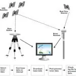
Use GPS Receiver to Field Survey
Conclusion
The relative positions of GPS stations are far from static, shaped by a complex interplay of tectonics, orbital mechanics, geophysics, and relativity. Yet, the GPS system, bolstered by global reference networks, dynamic modeling, and ever-improving technology, continues to deliver consistent and precise location data.
As we march into a future of autonomous vehicles, real-time augmented reality, and climate monitoring, this adaptability will only grow in importance. GPS is not just about where you are — it’s about understanding how everything is moving, all the time


Please i need more help from you
what type of help expect you from GISRSSTUDY?