Buy Best Garmin GPS
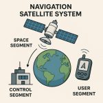
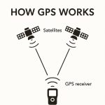
The Global Positioning System (GPS) is a satellite-based navigation system made up of at least 24 satellites. GPS works in any weather conditions, anywhere in the world, 24 hours/day.
List of the Best Garmin GPS to Buy in 2025
1. Garmin Foretrex 701
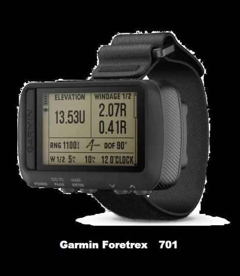
- Durable, constructed to military standards (MIL-STD-810G); night vision goggle compatible
- Works with GPS, GLONASS and Galileo satellite systems to provide accurate positioning
- Know where you are with navigation sensors, including 3-axis accelerometer, 3-axis compass and a barometric altimeter; smart notifications1 allow your device to receive emails, texts and alerts
- Foretrex 701 adds Applied Ballistics Elite software that calculates aiming solutions for long-range shooting
- Battery life exceeds 48 hours in navigation mode, up to 1 week in UltraTrac mode and up to 1 month in watch mode
Foretrex 701 Specification
General
| Physical dimensions | 7.3 x 4.3 x 2.2 cm |
| Weight | 87.8 g with batteries |
| Water rating | IPX7 |
| Battery | 2 AAA batteries (not included) |
| Display type | High-resolution 4-colour grey |
| Display size | 2.0″ diagonal |
| Display resolution | 200 x 128 pixels |
| Battery life | Exceeds 48 hours in GPS mode; up to 1 week in UltraTrac mode; up to 1 month in watch mode |
| Interface | USB |
Maps & Memory
| Basemap | ✔ |
| Waypoints/favorites/locations | 500 |
| Routes | 20 |
| Track log | 10,000 |
Sensors
- Barometric Altimeter
- COMPASS
Additional Features
- Applied Ballistics Elite
- Dual grid coordinates: customisable
- MIL-STD-810 Compliant: thermal, shock, water
- Night vision goggles compatible
- Audible tones
- GPS antenna type: patch
- GPS/GLONASS/Galileo support
- Saved tracks: 100/200 points per track
- Clock features: time/date, watch mode, military time format, GPS time sync, automatic daylight saving time, alarm clock, timer, stopwatch, sunrise/sunset times
- Customisable data pages
- Touch and/or button lock
- GPS speed and distance
- Sensor compatibility: HR strap, speed, cadence, VIRB®, tempe™
- GPS-based distance, time and pace
- Jumpmaster
- Point-to-point navigation
- Bread crumb trail in real time
- Back to start
- TracBack
- Elevation profile
- Distance to destination
- Barometric trend indicator
- Vertical speed
- Total ascent/descent
- Unit-to-unit route/location sharing
- GPS coordinates
- Projected waypoint
- Sight ‘N Go
- Smart notifications
- LiveTrack
In the Box
- Foretrex 701 Device
- Hook and loop wrist strap
- Strap extender
- USB cable
- Documentation
2. Garmin GPSMAP 276Cx
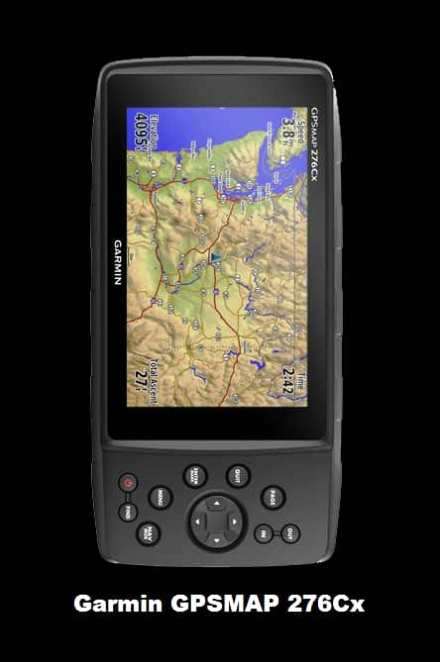
- Internal antenna with GPS and GLONASS satellite reception for tracking in more challenging environments than GPS alone; for better reception in vehicle interiors add an external antenna (sold separately) to the built-in MCX connector
- Built-in worldwide basemap and free 1-year BirdsEye Satellite Imagery subscription
- Supports Garmin TOPO maps, Garmin Hunt View maps, BlueChart g2 HD marine charts and more
- Supports Active Weather forecasts and animated weather tracking
- Pairs with your compatible smartphone¹ for automatic uploads, smart notifications and more
GPSMAP 276Cx Specification
General
| Physical dimensions | 7.5″ x 3.7″ x 1.7″ (191.5 x 94.5 x 44.0 cm) |
| Weight | 15.9 oz (450 g) with included rechargeable pack; 14.6 oz (415 g) with AA batteries (not included) |
| Water rating | IPX7 |
| Battery type | rechargeable lithium-ion (included) or 3 AA batteries (not included); NiMH or Lithium recommended |
| Display type | bright, sunlight readable WVGA display |
| Display size | 5.0″ (127.0 mm) diagonal |
| Display resolution | 800 x 480 pixels |
| Battery life | up to 16 hours (lithium-ion); up to 8 hours (AA batteries) |
| Memory | 8 GB (6 GB available to use) |
| High-sensitivity receiver | ✔ |
| Interface | high-speed USB and NMEA 0183 compatible |
Maps & Memory
| Basemap | ✔ |
| Ability to add maps | ✔ |
| Accepts data cards | microSD™ card (not included) |
| Custom POIs (ability to add additional points of interest) | ✔ |
| Waypoints/favorites/locations | 10,000 |
| Routes | 250 |
| Track log | 20,000 points, 250 saved tracks |
Sensors
- Barometric Altimeter
- COMPASS
Additional Features
- Map segments: 15,000
- Wi-Fi
- ANT+
- Bluetooth
- Active weather
In the Box
- GPSMAP 276Cx Device
- 1 year BirdsEye Satellite Imagery subscription¹
- AMPS powered mounting bracket with marine bail mount
- Lithium-ion rechargeable battery pack
- USB cable
- AC charger
- Documentation
3. Garmin inReach Explorer+

- 100 % global Iridium satellite coverage enables two way text messaging from anywhere
- Satellite communicator with Global Iridium
- One of the best GPS for battery life
- SOS for search and rescue with the GEOS Safety Center
- Two-way text messaging
- Bluetooth to phone with the Garmin App
- GPS tracking to share location
- Longer battery life (100 hours) depending on the mode
inReach Explorer+ Specification
General
| Physical dimensions | 2.7″ x 6.5″ x 1.5″ (6.8 x 16.4 x 3.8 cm) with keypad and SOS door bump |
|---|---|
| Display Size | 1.4″W x 1.9″H (3.5 x 4.7 cm); 2.31″ diag (5.9 cm) |
| Display resolution | 200 x 265 pixels |
| Display Type | transflective color TFT |
| Weight | 7.5 oz (213.0 g) |
| Battery type | Rechargeable internal lithium-ion |
| Battery life | Up to 100 hours at 10-minute tracking mode (default) Up to 75 hours at 10-minute tracking with 1-second logging Up to 30 days at the 30-minute interval power save mode Up to 3 years when powered off |
| Waterproof | IPX7 |
| Interface | micro USB |
| Memory | 2 GB (user space varies based on included mapping) |
Maps & Memory
| Preloaded maps | yes. The North America SKU of the inReach Explorer+ comes preloaded with a 1:24k map of Garmin Yarmouth (Former DeLorme) North America data of the U.S. and Canada. Mexico also is included at a 1:125k scale (derived from Garmin Yarmouth’s Digital Atlas of the Earth). |
|---|---|
| Ability to add maps | ✔ |
| Basemap | ✔ |
| Includes detailed hydrographic features (coastlines, lake/river shorelines, wetlands and perennial and seasonal streams) | ✔ |
| Displays national, state and local parks, forests, and wilderness areas | ✔ |
| Waypoints/favorites/locations | 500 |
| Tracks | single dynamic track |
| Navigation Track Log | single auto overwrite track log |
| Navigation Routes | 20, 200 points per route |
Sensors
- GPS
- High-Sensitivity Receiver
- COMPASS
- GPS COMPASS (while moving)
- Barometric Altimeter
In the Box
- inReach Explorer+ Device
- Preloaded with TOPO
- USB cable
- Carabiner clip
- Documentation
4. Garmin Montana 700
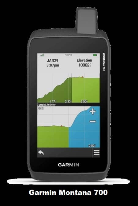
- 4-inch dual-orientation, glove-friendly touchscreen display
- 10.2 ounces extra weight
- 8 Megapixel Camera with automatically geotags photos
- Preloaded with 100,000 topographical map and 250,000 geocaches
- 1-year subscription to birds-eye satellite imagery
- BaseCamp software for pre-planning trips
- 22-hour battery life (AA batteries)
Montana 700 Specification
General
| Physical dimensions | 2.9″ x 5.7″ x 1.4″ (7.48 x 14.42 x 3.64 cm) |
|---|---|
| Touchscreen | ✔ |
| Display Size | 2″W x 3.5″H (5.06 x 8.93 cm); 4″ diag (10.2 cm) |
| Display resolution | 272 x 480 pixels |
| Display Type | bright, transflective 65K color TFT, dual-orientation touchscreen; sunlight readable |
| Weight | 10.2 oz (289 g) with included lithium-ion battery pack; 11.7 oz (333 g) with 3 AA batteries (not included) |
| Battery type | rechargeable lithium-ion (included) or 3 AA batteries (not included); NiMH or Lithium recommended |
| Battery life | up to 16 hours (lithium-ion) up to 22 hours (AA batteries) |
| Waterproof | IPX7 |
| Interface | high speed mini USB and NMEA 0183 compatible |
| Memory | 4 GB |
Maps & Memory
| Ability to add maps | ✔ |
|---|---|
| Basemap | ✔ |
| Automatic routing (turn by turn routing on roads) for outdoor activities | Yes (with optional mapping for detailed roads) |
| Map segments | 4000 |
| BirdsEye | 250 BirdsEye Imagery files |
| Includes detailed hydrographic features (coastlines, lake/river shorelines, wetlands and perennial and seasonal streams) | no (additional mapping needed) |
| Includes searchable points of interests (parks, campgrounds, scenic lookouts and picnic sites) | no (additional mapping needed) |
| Displays national, state and local parks, forests, and wilderness areas | no (additional mapping needed) |
| External memory storage | yes (32 GB max microSD™ card) |
| Waypoints/favorites/locations | 4000 |
| Tracks | 200 |
| Navigation Track Log | 10000 points, 200 saved tracks |
| Navigation Routes | 200, 250 points per route; 50 points auto routing |
Sensors
- GPS
- GLONASS
- High-Sensitivity Receiver
- COMPASS
- GPS COMPASS (while moving)
- Barometric Altimeter
In the Box
- Montana 700 Device
- Lithium-ion battery pack
- USB cable
- AC charger
- Quickstart Guide
5. Garmin GPSMAP 66sr
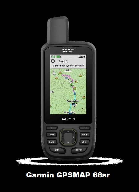
- Large 3 inch Sunlight-readable color display for easy viewing
- Trigger an interactive SOS to the geos 24/7 search and rescue monitoring center, two-way messaging via the 100% Global Iridium satellite network (satellite subscription required)
- Preloaded Garmin TOPO mapping with direct-to-device Birdseye satellite imagery downloads (no annual subscription), includes multiple global navigation satellite systems (GNSS) support and navigation sensors
GPSMAP 66sr Specification
General
| Physical dimensions | 2.5″ x 6.4″ x 1.4″ (6.2 x 16.3 x 3.5 cm) |
| Display size | 1.5″W x 2.5″H (3.8 x 6.3 cm); 3″ diag (7.6 cm) |
| Display resolution | 240 x 400 pixels |
| Display type | transflective color TFT |
| Weight | 8.1 oz (230 g) with batteries |
| Battery type | Rechargeable, internal lithium-ion |
| Battery life | Up to 36 hours Up to 450 hours in expedition mode |
| Water rating | IPX7 |
| MIL-STD-810 | (thermal, shock, water) |
| High-sensitivity receiver | ✔ |
| Interface | high speed micro USB and NMEA 0183 compatible |
| Memory | 16 GB (user space varies based on included mapping) |
Maps & Memory
| Preloaded maps | (basemap only) |
| Ability to add maps | ✔ |
| Basemap | ✔ |
| Automatic routing (turn by turn routing on roads) for outdoor activities) | ✔ |
| Map segments | 15000 |
| BirdsEye | (direct to device) |
| External memory storage | (32 GB max microSD card) |
| Waypoints/favorites/locations | 10000 |
| Tracks | 250 |
| Track log | 20000 points, 250 saved gpx tracks, 300 saved fit activities |
| Routes | 250, 250 points per route; 50 points auto routing |
| Rinex logging | ✔ |
Sensors
- GPS
- GLONASS
- IRNSS
- GALILEO
- COMPASS
- GPS COMPASS (while moving)
- Barometric Altimeter
In the Box
- GPSMAP 66sr Device
- USB cable
- Carabiner clip
- Documentation
6. Garmin eTrex 22x
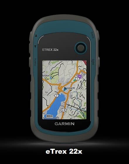
- 2.2” sunlight-readable color display with 240 x 320 display pixels for improved readability
- Preloaded with TopoActive maps with routable roads and trails for cycling and hiking
- Support for GPS and GLONASS satellite systems
- Allows for tracking in more challenging environments than GPS alone
- 8 GB of internal memory plus a microSD™ card slot
- eTrex 32x adds a 3-axis compass and barometric altimeter
- Battery life: up to 25 hours in GPS mode with 2 AA batteries
eTrex 22x Specification
General
| Physical dimensions | 2.1″ x 4.0″ x 1.3″ (5.4 x 10.3 x 3.3 cm) |
| Display size | 1.4″ x 1.7″ (3.5 x 4.4 cm); 2.2″ diag (5.6 cm) |
| Display resolution | 240 x 320 pixels |
| Display type | 2.2″ transflective, 65K color TFT |
| Weight | 5 oz (141.7 g) with batteries |
| Battery type | 2 AA batteries (not included); NiMH or Lithium recommended |
| Battery life | 25 hours |
| Water rating | IPX7 |
| High-sensitivity receiver | ✔ |
| Interface | mini USB |
| Memory | 8 GB |
Maps & Memory
| Preloaded maps | (TopoActive; routable) |
| Ability to add maps | ✔ |
| Basemap | ✔ |
| Automatic routing (turn by turn routing on roads) for outdoor activities | ✔ |
| Map segments | 3000 |
| BirdsEye | 250 BirdsEye Imagery files |
| Includes detailed hydrographic features (coastlines, lake/river shorelines, wetlands and perennial and seasonal streams) | ✔ |
| Includes searchable points of interests (parks, campgrounds, scenic lookouts and picnic sites) | ✔ |
| Displays national, state and local parks, forests, and wilderness areas | ✔ |
| External memory storage | (32 GB max microSD™ card) |
| Waypoints/favorites/locations | 2000 |
| Tracks | 200 |
| Track log | 10000 points, 200 saved tracks |
| Routes | 200 routes, 250 points per route; 50 points auto routing |
Sensors
- GPS
- GLONASS
- GPS COMPASS (while moving)
In the Box
- eTrex 22x Device
- USB cable
- Documentation
7. Garmin eTrex 10
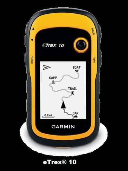
- Worldwide basemap
- 2.2″ monochrome display, easy to read in any light
- Support for paperless geocaching and Garmin spine mounting
- GPS and GLONASS satellites for faster positioning
- Paperless geocaching
- 25-hour battery life with 2 AA batteries
eTrex 10 Specification
General
| Physical dimensions | 2.1″ x 4.0″ x 1.3″ (5.4 x 10.3 x 3.3 cm) |
| Display size, WxH | 1.4″ x 1.7″ (3.6 x 4.3 cm); 2.2″ diag (5.6 cm) |
| Display resolution, WxH | 128 x 160 pixels |
| Display type | transflective, monochrome |
| Weight | 5 oz (141.7 g) with batteries |
| Battery | 2 AA batteries (not included); NiMH or Lithium recommended |
| Battery life | 25 hours |
| Water rating | IPX7 |
| High-sensitivity receiver | ✔ |
| Interface | USB |
Maps & Memory
| Basemap | ✔ |
| Custom POIs (ability to add additional points of interest) | ✔ |
| Waypoints/favorites/locations | 1000 |
| Routes | 50 |
| Track log | 10,000 points, 100 saved tracks |
Sensors
- GPS
- GLONASS
In the Box
- eTrex 10 Device
- USB cable
- Manual