GLONASS- Global Navigation Satellite System
GLONASS stand for Global Navigation Satellite System, Russia, it is a space-based Global Navigation Satellite System (GNSS), operated by the Russian Federation. The GLONASS is a part of GPS System. The first GLONASS satellite was launched in 1982 and the system was declared fully operational in 1993.
GLONASS System
GLONASS System provides real-time positioning and timing data for users around the world.
Orbital Constellation:
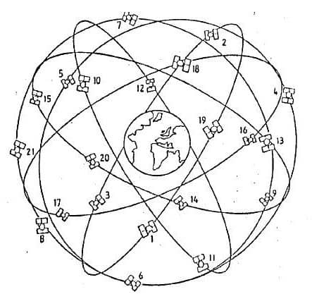
24 Satellites
(3 planes x 8 satellites)
Orbit type: circular,
H = 19 100 km,
i = 64.8°
Orbital period:
11 hr 15 min
The orbits are shifted by
120° along the equator
As with GPS, the GLONASS system design consists of 3 parts:
GLONASS Satellite Constellation
| Capabilities | Glonass | Glonass-M | Glonass-K | Glonass-K2 |
|---|---|---|---|---|
| Time of Deployment | 1982-2005 | 2003-2016 | 2011-2018 | 2017+ |
| Status | Decommissioned | In use | Design maturation based on in-orbit validation | In development |
| Nominal Orbit Parameters | Circular Altitude – 19,100 km Inclination – 64,8° Period – 11 h 15 min 44 sec | |||
| Number of Satellites in the Constellation (Used for Navigation) | 24 | |||
| Number of Orbital Planes | 3 | |||
| Number of Satellites in a Plane | 8 | |||
| Launchers | Soyuz-2.1b, Proton-M | |||
| Design Lifetime, years | 3.5 | 7 | 10 | 10 |
| Mass, kg | 1500 | 1415 | 935 | 1600 |
| Dimensions, m | 2,71х3,05х2,71 | 2,53х3,01х1,43 | 2,53х6,01х1,43 | |
| Power, W | 1400 | 1270 | 4370 | |
| Platform Design | Pressurized | Pressurized | Unpressurized | Unpressurized |
| Clock Stability, as per Specification/Observed | 5✕10-13 / 1✕10-13 | 1✕10-13 / 5✕10-14 | 1✕10-13 / 5✕10-14 | 1✕10-14 / 5✕10-15 |
| Signal Type | FDMA | FDMA (+CDMA for SVs 755-761) | FDMA and CDMA | FDMA and CDMA |
| Open Access Signals (for FDMA Signals Center Frequency Values are Provided) | L1OF (1602 MHz) | L1OF (1602 MHz) L2OF (1246 MHz) L3OC (1202 MHz) for SVs 755+ | L1OF (1602 MHz) L2OF (1246 MHz) L3OC (1202 MHz) L2OC (1248 MHz) for SVs 17L+ | L1OF (1602 MHz) L2OF (1246 MHz) L1OC (1600 MHz) L2OC (1248 MHz) L3OC (1202 MHz) |
| Restricted Access Signals | L1SF (1592 MHz) L2SF (1237 MHz) | L1SF (1592 MHz) L2SF (1237 MHz) | L1SF (1592 MHz) L2SF (1237 MHz) L2SC (1248 MHz) for SVs 17L+ | L1SF (1592 MHz) L2SF (1237 MHz) L1SC (1600 MHz) L2SC (1248 MHz) |
Advantages of GLONASS
- Increased satellite signal observations
- Markedly increased spatial distribution of visible satellites
- Reduced Horizontal and Vertical Dilution of Precision (DOP) factors
- Decreased occupation times means faster RTK results
GLONASS development 2002 –– 2011
Phase I: Replenishment of the constellation with the existing GLONASS SV
- Maintaining the constellation at a minimal level.
Phase II: System upgrade using GLONASS-M SV
- Flight tests of the GLONASS-M SV in 2003.
- Guaranteed active life of 7 years.
- Transition to the agreed frequency band.
- Introducing a second frequency for the civil community.
- Test trials of elements for the advanced SNS.
Phase III: Further system upgrade using GLONASS-K SV
- Further upgrade of the SV active life to 10 years and more.
- Reducing the overall SV mass to provide launches of 6 to 8 SV at a time by PROTON-M rocket launchers and 2 to 3 SV by SOYUZ-2 launchers.
- Upgrade of the ground control complex.
- Introducing a third frequency in the L-band.
- Improving navigation signal characteristics taking into consideration the growing navigation user requirements.
Comparison of GLONASS and GPS Characteristics
| Satellites | GLONASS | GPS |
|---|---|---|
| Number of satellites | 21 + 3 spares | 21 + 3 spares |
| Number of orbital planes | 3 | 6 |
| Orbital plane inclination (degrees) | 64.8 | 55 |
| Orbital radius (kilometers) | 25,510 | 26,560 |
| Signals | GLONASS | GPS |
|---|---|---|
| Fundamental clock frequency (MHz) | 5.0 | 10.23 |
| Signal separation technique | FDMA | CDMA |
| Carrier frequencies (MHz) | L1-1598.0625-1609.3125 L2-1242.9375-1251.6875 | 1575.42 1227.6 |
| Code clock rate (MHz) | C/A- 0.511 P- 5.11 | 1.023 10.23 |
| Code length (chips) | C/A- 511 P- 5.11 x 10 6 | 1 023 6.187104 x 10 12 |
| C/A-code Navigation Message | GLONASS | GPS |
|---|---|---|
| Superframe duration (minutes) | 2.5 | 12.5 |
| Superframe capacity (bits) | 7 500 | 37 500 |
| Superframe reserve capacity (bits) | ~620 | ~2 750 |
| Word duration (seconds) | 2.0 | 0.6 |
| Word capacity (bits) | 100 | 30 |
| Number of words within a frame | 15 | 50 |
| Technique for specifying satellite ephemeris | Geocentric Cartesian coordinates and their derivatives | Keplarian orbital elements and perturbation factors |
| Time reference | UTC (SU) | UTC (USNO) |
| Position reference (geodetic datum) | PZ-90 | WGS84 |