Analysis of GIS
GIS Analysis provides a broad range of powerful spatial modeling and analysis features. Using GIS Spatial Analyst, for users can create, query, map, and analyze cell-based Raster data; perform integrated Raster or Vector analysis.
It helps in decision-making across many fields such as urban planning, environmental management, disaster response, and business logistics.

Types of GIS Analysis
| Type | Description | Example |
|---|---|---|
| Spatial Analysis | Examines location, shape, and relationships between geographic features | Finding areas prone to flooding |
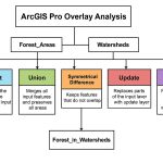
| Overlay Analysis | Combines multiple layers to extract meaningful data | Land use vs. soil type map |
| Proximity Analysis | Finds features within a given distance | Schools within 1 km of roads |
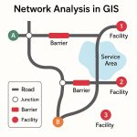
| Network Analysis | Analyzes movement and connectivity | Optimal route for delivery trucks |
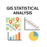
| Statistical Analysis | Applies statistical methods to spatial data | Population density vs. pollution levels |
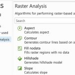
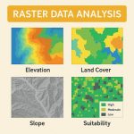
| Terrain Analysis | Uses elevation data (DEM) | Slope, aspect, hillshade maps |
| Suitability Analysis | Finds the best locations based on multiple criteria | Site selection for a new hospital |
Spatial Analysis
ArcGIS Spatial Analyst, user can take advantage of all the advanced functionality in ArcGIS as well as work with other extensions such as; ArcGIS Geostatistical Analyst and ArcGIS 3D Analyst.
Also, using ArcGIS Spatial Analyst, GIS users can derive information about geospatial data ;
such as Terrain analysis, Spatial relationships, Network analysis, suitable locations, and more.
Spatial analysis is a process in which you model problems geographically, derive results by computer processing, and then explore and examine those results.
ArcGIS Spatial Analyst integrates real-world geospatial environment to help solve complex problems. It is provides new functionality for advanced customization and interoperability, users can create more advanced raster models for their analysis.
Common Tools and Software for GIS Analysis:
| Software | Features |
|---|---|
| ArcGIS Pro | Advanced spatial, 3D, and network analysis |
| QGIS | Open-source; plugins for all types of GIS analysis |
| GRASS GIS | Strong in raster and terrain analysis |
| PostGIS | Spatial SQL for large databases |
| Python & R | Custom analysis using libraries like geopandas, PySAL, sf, raster |