Geocoding in QGIS
What is Geocoding?
A Geocoding is the process in GIS operation to transform a description of a location, such as a pair of coordinates, an address, or a name of a place to a location on a map.
The geocoding process are essentially attempts to determine the location of the input address over the range of addresses in the reference dataset. The reference dataset used for the geocoding process determines the technique used in matching the spatial information into geographic coordinates. In most commercial GIS Software packages, the matching algorithm is embedded in an Address locator.
Perform Geocode Addresses Using QGIS
In this Tutorial discuses about, how to apply Geocoding in QGIS.
Before you get started geocoding, make sure that your addresses are stored in a CSV file.
There are two types of web services available to perform this task: Google Maps and OpenStreetMap.
Install Geocoding QGIS Plugin – MMQGIS
You will need to first install the plugin MMQGIS in QGIS Desktop.
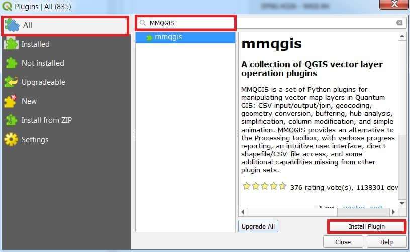
1. Open to the Plugin Manager, click on the menu item Plugins > Manage and Install Plugins.
2. The Plugin dialog box open, in the search box, search MMQGIS plugin.

3. Now install this plugin and use it.
Geocode Types
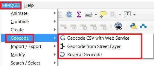
Now plugin is installed, you can access the Geocoding function by click on MMQGIS > selecct Geocode.

There are three types of geocoding options:
- Geocode CSV with Web Service
- Geocode from Street Layer
- Reverse Geocode
Geocoding Address File
For this tutorial, using Google’s geocoding API.
1. Open Geocode CSV with Web Service.
2. Web Service Geocode window appear, fill the all parameters.
3. Once you have set all the parameters, click the OK button to start geocoding.
4. The process is completed, geocoded file will automatically added to the layers section. Now view your result with Attribute Table.
