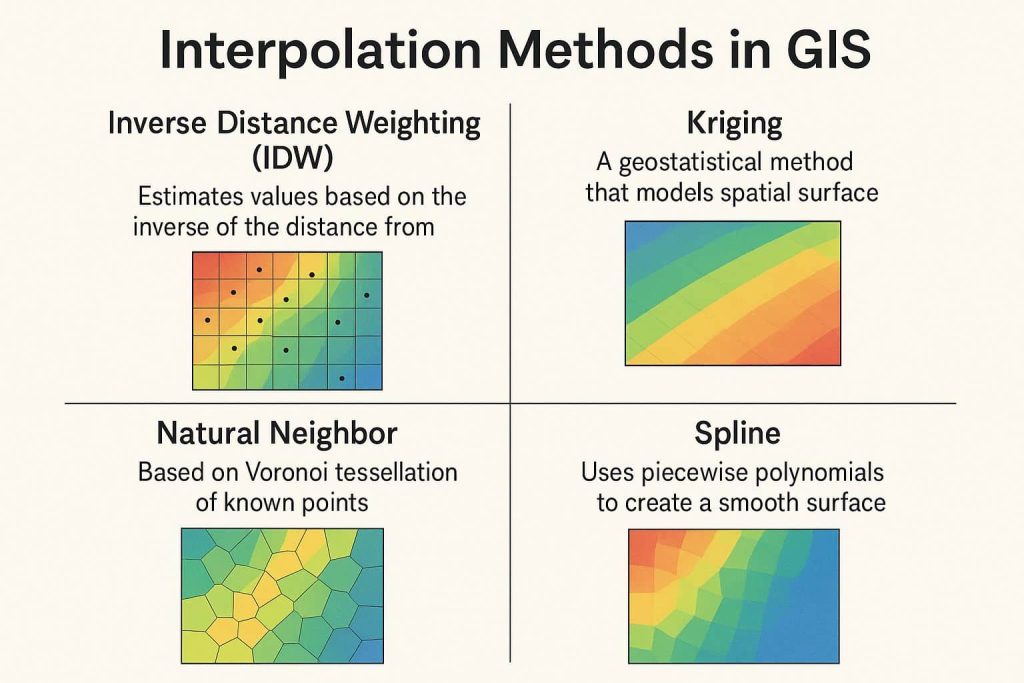
GISRSStudy » ArcGIS » Page 24

ArcGIS

ArcGIS Developed by ESRI,  use for mapping and analytics platform.

ArcMap Provides GIS and Mapping Products- ArcGIS Online, ArcGIS Pro, ArcGIS Enterprise, ArcGIS for Developers.

In below list of ArcGIS Tutorial.

Geoprocessing

Geoprocessing Tools in ArcGIS Geoprocessing Tools can improve your productivity because the tools apply edits in bulk, such as to all features or all selected features. In most cases, a similar editing function applies to only one feature at a time. In this Tutorial Learn use Geoprocessing Tools in ArcGIS. Uses of Geoprocessing Geoprocessing Tools in a model to …

Geoprocessing Read More »

KML File to Shapefile

Convert KML File to Shapefile in ArcGIS Keyhole Markup Language (KML) is an Geographic Data , basically it is a Google Earth Data structure. In this Tutorial Learn how to convert KML file to Shapefile. Save or Export KML file, first open Google Earth. now you can search any places or create polygon, path or …

KML File to Shapefile Read More »

Surface Analysis

Surface Analysis Map in ArcGIS Surface Analysis represents height values for an Elevation surface or structure of a Surface. In this Tutorial Learn how to create different types of Surface Analysis map in ArcGIS. Now perform to 6 Surface Analysis model. Aspect Contour Curvature Hillshade Slope Viewshade Launch ArcGIS software, then open the Toolbox, ArcToolbox window is …

Surface Analysis Read More »

Interactive R 2 V Conversion

Interactive R2V Conversion (Convert Raster to Vector) Using ArcScan This Tutorial Learn How to Convert Raster to Vector in ArcGIS, and it‘s called Interactive R2V Conversion or Interactive Tracing. Prepare Map Add an Image (US.jpg) on ArcMap your Raster image is RGB Format. At first, convert to float, otherwise, you don’t perform this task. Raster to Float 1. Open a Search pane, in the search box search Raster to float. Now select Raster to …

Interactive R 2 V Conversion Read More »

Tin- ArcGIS

Triangulated Irregular Network (TIN) Triangulated Irregular Network (TIN) represent surface morphology. TINs are a form of vector-based digital Geographic data and are constructed by triangulating a set of points (vertices). The vertices are connected with a series of edges to form a network of triangles. In this Tutorial Learn how to create TIN in ArcScene. …

Tin- ArcGIS Read More »

Scroll to Top