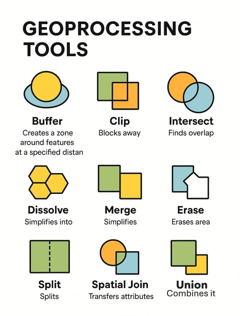
GISRSStudy » ArcGIS » Page 25

ArcGIS

ArcGIS Developed by ESRI,  use for mapping and analytics platform.

ArcMap Provides GIS and Mapping Products- ArcGIS Online, ArcGIS Pro, ArcGIS Enterprise, ArcGIS for Developers.

In below list of ArcGIS Tutorial.

Collector for ArcGIS

ArcGIS Collector ArcGIS Collector offer to collect and update information in the field, use your smartphone or tablet. Try Collector, you took a sample map to the field and captured information about your local area. ArcGIS Collector Online Arc GIS Collector Field Maps is an all-in-one app that uses data-driven maps to help mobile workers […]

Collector for ArcGIS Read More »

ArcGIS Desktop

ArcGIS for Desktop ArcGIS Desktop offer for GIS professionals to create, analyze, manage, and share Geographic Information so decision makers can make intelligent, informed decisions. It’s allows to create maps, perform spatial analysis, and manage data. Features ArcGIS Desktop Download The ArcGIS Released Version: 10.8 (February 2020). Download ArcGIS Desktop and create mapping and analysis.

ArcGIS Desktop Read More »

ArcGIS StoryMaps

ArcGIS Story Maps What is ArcGIS StoryMaps? ArcGIS StoryMaps is a story authoring web-based application, create inspiring, immersive stories by combining text, interactive maps, and other multimedia content. Publish and share your story with your organization or everyone around the World. ArcGIS Story Map Feature Advantages of ArcGIS Story Maps ArcGIS Online Story Maps 1.

ArcGIS StoryMaps Read More »

ArcGIS Developer

ArcGIS Developer ArcGIS Developer access to APIs, location services, and tools to develop your own mapping and spatial analysis applications. Use mapping products for developers to build web, native, offline, desktop, or integrated solutions for yourself, your organizations. Access a full suite of location services to provide Basemap layers, Geocoding and routing capabilities, and other

ArcGIS Developer Read More »

Learn ArcGIS Pro

ArcGIS Pro What is ArcGIS Pro? ArcGIS Pro is a powerful, single desktop GIS application, and ESRI‘s Geospatial Cloud. The ArcGIS Pro supports data visualization, advanced analysis and authoritative data maintenance in both 2D and 3D. Features Extensions 3D Analyst Business Analyst Geostatistical Analyst Image Analyst Network Analyst Spatial Analyst Data Interoperability Data Reviewer Indoors

Learn ArcGIS Pro Read More »

Scroll to Top