GPS Survey: Equipment
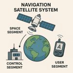
GPS is a vital part of surveying and mapping activities around the world. It was one of the first to take advantage, because it dramatically increased productivity and resulted in more accurate and reliable data.
GPS supports the accurate mapping and modeling of the physical world — from mountains and rivers to streets and buildings to utility lines and other resources. Features measured with GPS can be displayed on maps and in Geographic Information System (GIS) that store, manipulate, and display geographically referenced data.

GPS Survey Example
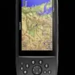
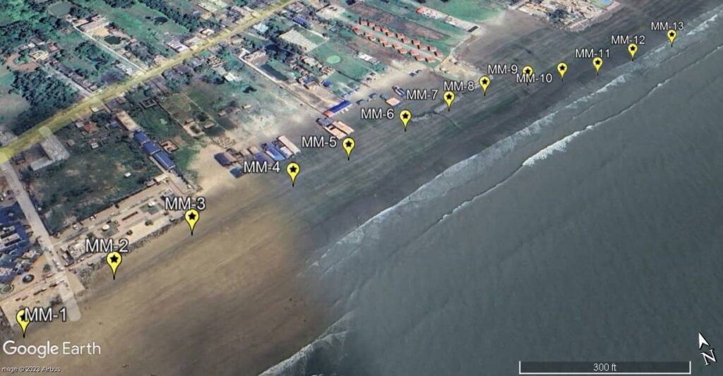
In the example of Mandarmani sea beach Survey, using Garmin eTrex 10 GPS Device. AOI below the entire area mapped was 1.3 square miles. The 15 GCPs that were available are shown tagged in the ortho and did not represent the best spatial distribution for an area of that size.
Mandarmani- 1:
| Sl No. | Waypoints | Latitude (N) | Longitude (E) | Distance from preceding waypoint (m) | Elevation (m) |
|---|---|---|---|---|---|
| 1 | MM-1 | 21°39’42.70″ | 87°42’3.89″ | 0 | 6.398827 |
| 2 | MM-2 | 21°39’43.53″ | 87°42’5.53″ | 54.4 | 8.215771 |
| 3 | MM-3 | 21°39’44.09″ | 87°42’7.17″ | 51.3 | 7.965897 |
| 4 | MM-4 | 21°39’44.90″ | 87°42’9.62″ | 76.4 | 8.644405 |
| 5 | MM-5 | 21°39’45.42″ | 87°42’11.18″ | 47.8 | 6.45826 |
| 6 | MM-6 | 21°39’46.00″ | 87°42’12.95″ | 53.4 | 5.289703 |
| 7 | MM-7 | 21°39’46.41″ | 87°42’14.41″ | 44.0 | 6.224339 |
| 8 | MM-8 | 21°39’46.80″ | 87°42’15.73″ | 38.7 | 5.74778 |
| 9 | MM-9 | 21°39’46.90″ | 87°42’17.19″ | 43.4 | 5.019794 |
| 10 | MM-10 | 21°39’46.84″ | 87°42’18.33″ | 33.6 | 5.019794 |
| 11 | MM-11 | 21°39’46.88″ | 87°42’19.62″ | 38.0 | 4.10062 |
| 12 | MM-12 | 21°39’47.26″ | 87°42’21.22″ | 48.1 | 4.033909 |
| 13 | MM-13 | 21°39’47.60″ | 87°42’23.03″ | 54.2 | 3.587029 |
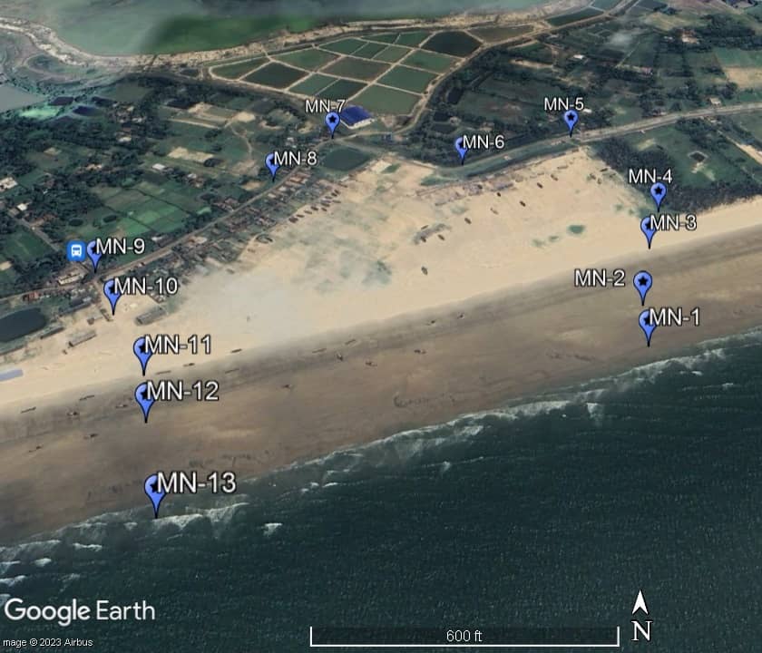
Mandarmani- 2:
| Sl No. | Waypoints | Latitude (N) | Longitude (E) | Distance from preceding waypoint (m) | Elevation (m) |
|---|---|---|---|---|---|
| 1 | MN-1 | 21°39’42.70″ | 87°42’3.89″ | 0 | 3.587029 |
| 2 | MN-2 | 21°39’43.53″ | 87°42’5.53″ | 51.1 | 4.194954 |
| 3 | MN-3 | 21°39’44.09″ | 87°42’7.17″ | 82.5 | 5.659748 |
| 4 | MN-4 | 21°39’44.90″ | 87°42’9.62″ | 61.2 | 7.906815 |
| 5 | MN-5 | 21°39’45.42″ | 87°42’11.18″ | 166.0 | 5.358456 |
| 6 | MN-6 | 21°39’46.00″ | 87°42’12.95″ | 126.0 | 10.388199 |
| 7 | MN-7 | 21°39’46.41″ | 87°42’14.41″ | 148.0 | 10.610287 |
| 8 | MN-8 | 21°39’46.80″ | 87°42’15.73″ | 93.8 | 9.939461 |
| 9 | MN-9 | 21°39’46.90″ | 87°42’17.19″ | 192.0 | 15.925201 |
| 10 | MN-10 | 21°39’46.84″ | 87°42’18.33″ | 66.8 | 8.772717 |
| 11 | MN-11 | 21°39’46.88″ | 87°42’19.62″ | 87.3 | 1.745041 |
| 12 | MN-12 | 21°39’47.26″ | 87°42’21.22″ | 53.5 | 0.765091 |
| 13 | MN-13 | 21°39’47.60″ | 87°42’23.03″ | 93.6 | 0.265633 |
GPS Survey Equipment
GPS Survey Equipment is used in geospatial, land, and construction surveying to precisely determine locations and measurements using satellite signals. Here’s an overview of the main types and components:

Types of GPS Survey Equipment
- Handheld GPS Receivers
- Portable and affordable.
- Suitable for general navigation and basic mapping.
- Accuracy: 2–5 meters.
- Mapping Grade GPS
- Used in GIS data collection (e.g., Trimble Geo 7X, Garmin GPSMAP).
- Accuracy: 0.5–1 meter (with differential correction).
- Survey Grade GPS (GNSS)
- High-precision units used by professionals (e.g., Leica, Trimble, Topcon, Hemisphere).
- Dual/Triple frequency receivers using RTK or PPK.
- Accuracy: 1 cm or better.
GPS Survey Components
| Component | Description |
|---|---|
| GNSS Receiver | Captures satellite signals (GPS, GLONASS, Galileo, BeiDou). |
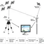
| Base Station | Fixed unit that sends corrections to the rover (RTK setup). |
| Rover | Mobile unit receiving corrections for precise positioning. |
| Data Collector | Field tablet/handheld for logging data (often with software like Trimble Access or FieldGenius). |
| Antenna | High-quality external GNSS antenna for better signal. |
| Tripod/Pole | Mounting tool to stabilize receiver or antenna. |
Essential Equipment
The GPS & GNSS survey equipment are.
- GNSS Receiver – Captures satellite signals (supports GPS, GLONASS, Galileo, BeiDou).
- Antenna – High-precision antenna for signal reception.
- Data Collector – Rugged handheld with software for recording data (e.g., Trimble Access, Carlson SurvCE).
- Survey Pole/Tripod – Mounts for positioning the receiver.
- Base Station (for RTK) – Stationary receiver providing real-time corrections to rover.
- Power Supply & Carrying Case – Batteries and rugged transport/storage cases.
- GPS Device
- RTK GPS Systems
- Sub Meter GPS
- GNSS Receivers (DGPS)
- External Radios
- Depth Sounder
- Accessories
- External Radio Cable
- Rover Pole
- Drone
Popular GPS Survey Equipment Brands
- Trimble (e.g., R12i, R8s)
- Leica Geosystems (e.g., GS18 T)
- Topcon (e.g., HiPer VR)
- CHC Navigation
- Emlid (e.g., Reach RS2+)
- South Surveying & Mapping