Cloud GIS
In today’s interconnected world, understanding spatial relationships is as critical as interpreting facts or statistics. Geographic Information Systems (GIS) have long served as a cornerstone for spatial analysis, enabling users to collect, manage, analyze, and visualize geospatial data. Traditionally, GIS demanded robust local infrastructure, including high-powered desktops, expensive proprietary software, and intricate databases. However, the advent of cloud computing has catalyzed a transformative shift in how GIS is deployed, accessed, and utilized.
What is Cloud GIS?
Cloud GIS is a web-based GIS, powered by cloud computing. Its provides full desktop GIS features enriched by the web. You can easily and efficiently visualize data, customized mapping reports, geographic analysis and explore geographic information.
Cloud-based GIS refers to the delivery of GIS capabilities, including software, data storage, and computational resources—via cloud infrastructure. Unlike traditional GIS systems that rely on local servers or individual machines
Key Characteristics and Advantages
- Scalability– Cloud GIS solutions provide elastic computing capabilities that can automatically scale based on workload. This means whether an analyst is processing a small dataset or performing large-scale raster analysis on terabytes of satellite imagery, the system can dynamically allocate resources without taxing local machines.
- Universal Accessibility– One of the standout benefits of cloud GIS is its accessibility. Users can log into cloud GIS applications from any internet-connected device, bypassing the need for heavy software installations. This empowers field personnel, remote teams, and global collaborators to access and update geospatial data in real time.
- Enhanced Collaboration and Real-Time Sharing– Cloud platforms facilitate multi-user access, allowing simultaneous edits, annotations, and discussions on shared maps and datasets. Real-time updates ensure all stakeholders are aligned, streamlining decision-making and reducing errors associated with file versioning or manual data transfers.
- Cost-Efficiency– Cloud-based subscription models or pay-as-you-go pricing, organizations avoid the upfront capital expenditure of purchasing and maintaining hardware. Operational costs become predictable and scalable, enabling even small entities to leverage powerful GIS tools without budgetary constraints.
Core Components
| Components | Functionality |
|---|---|
| Cloud Infrastructure | Hosts GIS platforms, databases, and processing engines using services like AWS, Azure, and Google Cloud |
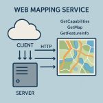
| Web Mapping Services | Delivers maps and geospatial data through standards like WMS, WMTS, and tile caching mechanisms |
| Spatial Databases | Manages and queries spatial data using technologies like PostGIS, SpatiaLite, or Big Query GIS |
| APIs & SDKs | Enables developers to integrate GIS functions into custom apps using tools like Leaflet, Mapbox GL JS, or Esri JS API |
| Data Integration Tools | Connects GIS to external data sources such as IoT devices, satellite imagery, and social media feeds |
Cloud-Based GIS Applications
Cloud-based GIS transcends the simple hosting of GIS software on the internet. It represents an integrated, service-oriented ecosystem where spatial data, analytical tools, and users converge on distributed, scalable cloud platforms. This shift has redefined possibilities for professionals in fields such as urban planning, environmental science, logistics, and emergency response, allowing for real-time collaboration, data sharing, and interactive visualization at a global scale.
Various applications are available in GIS Cloud, to help you manage and visualize the data– QGIS Cloud, ArcGIS Cloud, MyGeodata Cloud, AWS GIS, and more.
QGIS Cloud
QGIS Cloud is your personal spatial data infrastructure on the internet. Publish QGIS projects as maps and data. Also Share spatial data with others.
Learn more about QGIS Cloud/Online
ArcGIS Cloud
ArcGIS Enterprise deploys many cloud platforms:
ArcGIS Enterprise in the cloud
ArcGIS Enterprise takes advantage of multiple types of cloud resources, such as virtual machines, database services, and cloud storage, to implement functionality.
ArcGIS Enterprise implementation in a cloud environment, consider how you will deploy the software and which cloud features you’ll use as part of your Enterprise deployment.
Learn more about ArcGIS Enterprise Cloud
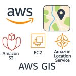
AWS GIS
Use ArcGIS Enterprise Cloud Builder for Amazon Web Services to deploy ArcGIS Enterprise and ArcGIS Server sites on AWS.
AWS provides you with tools to help you deploy the components of ArcGIS Enterprise on AWS.
Microsoft Azure
ArcGIS Enterprise Cloud Builder for Microsoft Azure and use it to deploy ArcGIS Enterprise and build ArcGIS Server sites to fill specific roles in your deployment.
ArcGIS Enterprise Cloud Builder for Microsoft Azure allows you to deploy ArcGIS Enterprise, ArcGIS Server sites, ArcGIS Pro, and ArcGIS Desktop on Microsoft Azure virtual machines.
Learn more about Microsoft Azure
Esri Managed Cloud Services
Esri Managed Cloud Services experts work with you to select the cloud GIS approach that is right for your organization from adopting a 100 percent cloud infrastructure to adding a cloud deployment to your planned or existing capabilities.
As your business goals and needs change, Esri Managed Cloud Services can help you optimize your organization’s cloud capabilities to achieve the results you’re looking for.
Learn more about Esri Managed Cloud Services
ArcGIS Online
ArcGIS Online is a Cloud-based software to create and share interactive web maps.
Its world-class infrastructure allows your maps to scale, so thousands of people can concurrently interact with them.
Learn more about ArcGIS Online
MyGeodata Cloud
MyGeodata allows, share or uploads your own GIS data, converts them on-line to various GIS/CAD formats and coordinates systems, shows your GIS data on a map, share or publishes your data, and many more.
Learn more about MyGeodata Cloud
GIS Cloud Real-time Mapping
GIS Cloud web portal is a real-time mapping platform for field data collection, operations management, and collaboration. It works online, offline and on-premises.
To share data and maps with the public, convert your project into a branded Map Portal in less than 30 minutes.
Also, you can access your project privately through a simple Map Viewer interface.
Conclusion
Cloud-based GIS marks a fundamental evolution in the geospatial field. It not only enhances operational efficiency and data-driven decision-making but also lowers the entry barriers to advanced spatial analysis. By leveraging the scalability, flexibility, and collaborative potential of the cloud, organizations across sectors can harness the full power of geospatial intelligence. Looking ahead, the fusion of cloud GIS with AI, IoT, and immersive technologies will unlock even greater opportunities for innovation. Embracing this new frontier is essential for building smarter cities, safeguarding the environment, and responding to the complex spatial challenges of our time.