ArcGIS GeoJSON
What is GeoJSON?
GeoJSON is an JavaScript Object Notation (JSON). It is a open standard geospatial data interchange format that represents simple geographic features and their non-spatial attributes.
It uses a geographic coordinate reference system, World Geodetic System 1984, and units of decimal degrees.
GeoJSON Layer
The GeoJSON Layer allows you to add features from a GeoJSON file (.geojson). The file is referenced as a hosted file on the web. Because of this, the file must be publicly accessible.
Create a new GeoJSON Layer and set the properties within its constructor. In this specific example, the url to the USGS earthquakes live feed is added in addition to the copyright and popupTemplate properties.
GeoJSON on ArcGIS
In ArcGIS, working with GeoJSON is supported through multiple tools across different environments like ArcGIS Pro, ArcGIS Online, and ArcGIS API for Python.
How you can use GeoJSON files in an ArcGIS Enterprise portal and provides links to instructions:
- Add a GeoJSON file as an item to share it.
- Publish a hosted feature layer from a GeoJSON file.
- Export the layer data to a GeoJSON file.
- Add a GeoJSON file as a layer to Map Viewer or Map Viewer Classic .
- Use a URL to add a GeoJSON as a layer to Map Viewer.
Supported feature types:
GeoJSON supports the following feature types:
- Point (including addresses and locations)
- Line string (including streets, highways, and boundaries)
- Polygon (including countries, provinces, and tracts of land)
- Multipart collections of point, line string, or polygon features
Supported geometry types:
GeoJSON supports the following geometry types:
- Point
- LineString
- Polygon
- MultiPoint
- MultiLineString
- MultiPolygon
Convert / Export GeoJSON file in ArcMap
Converts features to JSON format. The fields, geometry, and spatial reference of features will be converted to their corresponding JSON representation and written to a file with a .json extension.
Open ArcTollbox, in the Conversion Tools group select JSON and open Features to JSON Tool.
Features to JSON window appears, select Input Features and also Output JSON then click OK button.
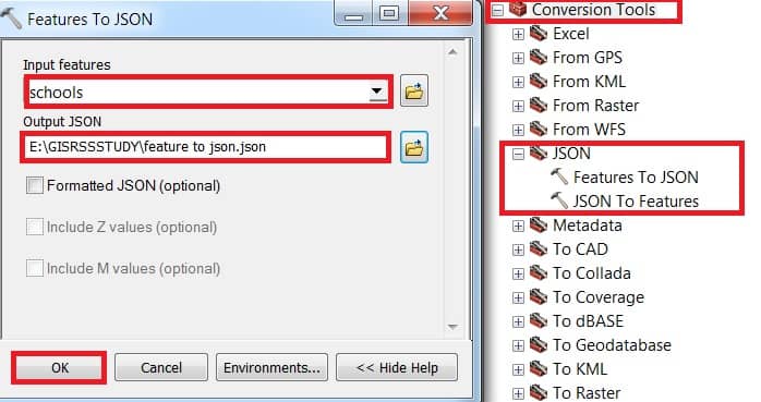
Now add GeoJSON file in ArcMap.
Importing GeoJSON in ArcGIS Pro
Steps:
- Open ArcGIS Pro.
- Go to Map tab > Click Add Data > Data.
- Navigate to your
.geojsonfile. - Click Open – it will be added as a feature layer.
Exporting a Layer to GeoJSON in ArcGIS Pro
Steps:
- Right-click the layer in the Contents pane.
- Click Data > Export Features.
- In the Geoprocessing tool, set output format:
- Choose
.json(which ArcGIS uses for GeoJSON).
- Choose
- Save with a
.geojsonextension and select WGS 84 as the coordinate system.
Using GeoJSON in ArcGIS Online
Steps:
- Go to ArcGIS Online Map Viewer.
- Click Add > Add Layer from File.
- Upload a
.geojsonfile. - It will display automatically on the map.