ArcGIS Basemap
Basemap provide a background of geographical context for your data.
What is Basemap?
A Basemap provides a background of geographical context for the content you want to display on a map.
A basemap is used for locational reference and provides a framework on which users overlay or mash up their operational layers, perform tasks, and visualize Geographic information.
Basemap layers are a kind of map layer that provides a framework on to which you display your dynamic operational information.
Characteristics of GIS Basemap:
- The basemap serves as a foundation for all subsequent operations and mapping.
- In utilities applications, a land base of parcel boundaries, buildings, and other built features is often used as a basemap.
- Many city maps use the street network as a basemap on top of which layers such as incidents and events are displayed.
ArcGIS Basemaps
An ArcGIS Basemap is a foundational map layer that provides contextual geographic information such as streets, terrain, satellite imagery, or topographic features. It serves as the backdrop for your GIS data visualization and analysis in ArcGIS Online, ArcGIS Pro, ArcGIS Enterprise, and ArcGIS Field Apps.
ESRI Basemaps is a ready-to-use map that serve as the geographic foundation. It is accessing a global collection of basemaps with localized languages and geographies, which can be customized to meet your unique needs.
Types of ArcGIS Basemaps
| Basemap Name | Description | Best Use Case |
|---|---|---|
| Imagery | High-resolution satellite and aerial imagery. | Visual analysis, real-world view, environmental mapping. |
| Imagery with Labels | Same as Imagery, but includes place names and boundaries. | Detailed visual reference with contextual information. |
| Topographic | Topographic map with elevation, roads, and landmarks. | Outdoor activities, hiking, terrain analysis. |
| Streets | Road-focused map with navigation and transportation features. | Urban planning, routing, and navigation. |
| Streets Navigation | Optimized for in-vehicle GPS navigation. | Fleet management, mobile mapping apps. |
| Streets (Night) | Dark theme optimized for low-light or nighttime conditions. | Night-time or dashboard visualization. |
| Light Gray Canvas | Minimal, neutral background for emphasizing overlay data. | Thematic mapping, data visualization. |
| Dark Gray Canvas | Dark, minimalistic background map. | Highlighting vibrant overlays; good for dashboards. |
| Terrain with Labels | Physical map showing shaded relief with topographic detail. | Physical geography, elevation studies. |
| Oceans | Ocean bathymetry and related marine data. | Marine science, oceanography, coastal mapping. |
| OpenStreetMap (OSM) | Open-source, community-driven map. | General reference; projects needing open data sources. |
| Charted Territory | Aesthetic, hand-drawn style basemap. | Creative or storytelling maps. |
| National Geographic | Map designed in the style of NatGeo maps. | Educational or themed map presentations. |
How to Add Basemaps in ArcGIS/ ArcMap?
To add basemap in ArcMap, do the following:
Steps:
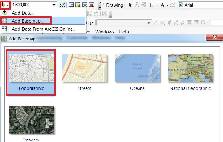
1. Click the Add Data drop-down arrow and click Add Basemap.
2. The Add Basemap window appears, select anyone basemap to fit your map, and click Add.
How to Change Basemaps in ArcGIS?
Change your basemap at any time, it’s very simple. For ex.- you choose Topographic basemap, switch to Imagery, just click it.
Add Basemaps in ArcGIS Pro
The ArcGIS Pro basemap gallery includes several pre-made basemap layers for you to use in your maps. After you add a map to your project, the basemap can be changed from the Map tab.
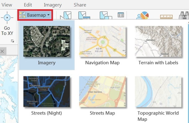
How to Change Basemaps in ArcGIS Pro?
You’ll change the Basemap to one that emphasizes your data. Change Basemap to more clearly symbol and also the ground point.
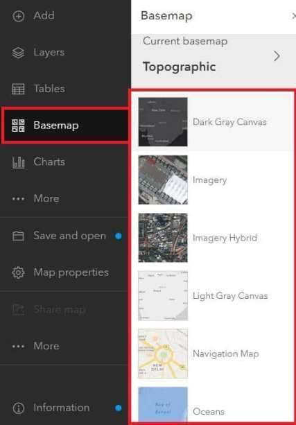
On the Map tab, in the Layer group, click Basemap and choose Basemap.
Use Basemaps in ArcGIS Online
First need to Sign up/ Lon in in ArcGIS Online Portal.
Open ArcGIS Map Viewer. In the Contents Toolbar (left side), click Basemap. See all are available Basemaps in the list.