Spatial Data Science
What is Spatial Data Science?
Spatial Data Science is a subset of Data Science techniques that focuses on the characteristics of spatial data, (geographic or location-based data) to extract meaningful insights, patterns, and predictions.
Its allows analysts to extract deeper insight from data using a comprehensive set of analytical methods and spatial algorithms, including machine learning and deep learning techniques.

Spatial Analytics and Data Science
Spatial Analysis and Data Science, discusses how data engineering can be the most difficult and time-consuming part of data analysis, and how new tools in ArcGIS Pro 3.4 will make these processes easier, to construct, format, clean, and integrate your data before it can be analyzed.
Components
- Geospatial Data: The raw input includes GIS data (shapefiles, GeoJSON, raster data, etc.), remote sensing data (satellite images, aerial imagery), and real-time data (e.g., GPS data).
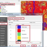
- Spatial Analysis: This involves techniques like spatial autocorrelation, hotspot analysis, and spatial interpolation to understand spatial patterns and relationships.
- Machine Learning: Algorithms like random forests, support vector machines, and deep learning models are applied to spatial data for classification, clustering, and prediction tasks.
- Big Data and Cloud Computing: Given the large volumes of geospatial data, tools like Hadoop, Spark, and cloud platforms are often used to process and analyze the data at scale.
- Visualization: Its heavily relies on powerful visualization techniques (interactive maps, 3D visualizations) to communicate insights clearly.
Workflows
- Data Acquisition – from satellites, drones, sensors, or open sources (e.g., OpenStreetMap).
- Data Cleaning & Transformation – using spatial joins, projections, and reclassifications.
- Exploratory Spatial Data Analysis (ESDA) – mapping, clustering, statistical summaries.
- Modeling – spatial regression, machine learning, simulation.
- Validation & Interpretation – cross-validation, interpretation of spatial outputs.
- Visualization & Communication – maps, dashboards, spatial animations.
Applications
- Urban Planning: Land use, infrastructure development, zoning analysis
- Environmental Monitoring: Deforestation tracking, climate modeling, pollution mapping
- Transportation: Route optimization, traffic prediction
- Public Health: Disease outbreak mapping, healthcare accessibility
- Agriculture: Crop yield prediction, precision farming
- Disaster Management: Flood risk analysis, evacuation planning
Data Science and ArcGIS
ArcGIS is a comprehensive analytics platform for data scientists. It enables you to unlock your data full potential by integrating data exploration, statistical and machine learning algorithms, and advanced modeling techniques.
Esri MOOC Spatial Data Science
Esri officially open a free Spatial Data Science: The New Frontier in Analytics Massive Open Online Courses (MOOCs) in 2020.
In this course already join over 15,000 people from around the globe. Over six weeks, participants will explore the power of spatial data science and discover the latest ArcGIS capabilities for machine learning, deep learning, predictive modeling, and more.
The course following:
- Step-by-step exercises, videos, quizzes, and discussion
- Access to ArcGIS Pro, ArcGIS Online, and ArcGIS Notebooks
- Certificate for course completion
Spatial Data Analytics Conference
The data science conference present for solve the spatial problems.
Its take a deeper dive into GeoAI, spatial stats, suitability analysis, network analysis, graph analytics, real-time analytics, and more.