Remotely Sensed Data
Introduction
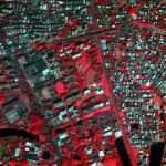
To the Earth’s surface without physical contact collect data through satellites, aircraft, or drones, that’s call Remote Sensing Data.
Remotely sensed data are the main data source used for land use mapping. This data are frequently used to identify specific plant species or vegetation types of indicative of wetlands. The most well-known and commonly used index to detect green vegetation from Multispectral remote sensing data is the Normalized Difference Vegetation Index (NDVI).
Remote Sensed Data acquired from satellites require processing before the data are usable by most researchers and applied science users. Most raw NASA Earth observation satellite data are processed at NASA’s Science Investigator-led Processing Systems (SIPS) facilities.
Once data are processed, they can be used in a variety of applications, from agriculture to water resources to health and air quality.
Types of Remote Sensing Data
- Optical Data (Visible, Near-IR, Shortwave IR)
- Captures reflected sunlight.
- Example sensors: Landsat, Sentinel-2, MODIS
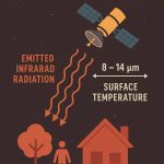
- Thermal Data
- Measures emitted infrared radiation (surface temperature).
- Example sensors: Landsat Thermal Infrared Sensor (TIRS), MODIS
- Radar Data (Microwave)
- Active sensor: sends signals and measures return (can work day/night, through clouds).
- Example sensors: Sentinel-1, RADARSAT, TerraSAR-X
- LiDAR Data (Light Detection and Ranging)
- Uses laser pulses to measure elevation.
- Produces high-resolution Digital Elevation Models (DEMs).
- Multispectral Data
- Captures a few broad bands (e.g., RGB, NIR).
- Common in vegetation, land cover analysis.
- Hyperspectral Data
- Captures hundreds of narrow spectral bands.
- Useful for detailed material identification.
Popular Remote Sensing Data Sources
List of Top 5 free Sources to download Remote Sensing Data:
- USGS Earth Explorer
- Bhuvan- ISRO
- NASA Earth Data
- ESA’s Sentinel data
- NASA Earth Observation (NEO)
| Source | Sensor | Data Types |
|---|---|---|
| USGS (USGS Earth Explorer) (Global Visualization Viewer) | Landsat series | 30m multispectral, free data |
| ESA (Sentinels Scientific Data Hub) | Sentinel-1, 2, 3 | SAR and 10m multispectral data |
| NASA (NASA Earth Observation) (Earth Science Data Systems) | MODIS, ASTER | Daily global coverage |
| ISRO (Bhuvan | NRSC Open EO Data) | Resourcesat, Cartosat | High-resolution, agriculture, land use |
| NOAA (Climate Data Online (CDO) (Digital Coast: Data Access Viewer) | AVHRR, GOES | Weather, sea surface temp. |
Applications
- Land use/land cover mapping
- Agriculture and crop monitoring
- Urban planning
- Disaster management (floods, fires)
- Forest and biodiversity analysis
- Climate change monitoring
- Mineral exploration
- Oceanography