QGIS Server
QGIS Server is an open-source WMS 1.3, WFS 1.0.0 and WCS 1 1.1.1, implements advanced cartographic features for thematic mapping. I6 is a FastCGI/CGI (Common Gateway Interface) application written in C++ that works together with a web server. It has Python plugin support allowing for fast and efficient development and deployment of new features. The original development was funded by the EU projects Orchestra, Sany and the city of Uster in Switzerland.
As QGIS desktop and QGIS Server use the same visualization libraries, the maps that are published on the web look the same as in desktop GIS. It allows you to publish GIS data and maps as standard OGC web services.
These services can then be consumed in:
- QGIS Desktop,
- Web GIS clients (like QWC2, Lizmap, or OpenLayers/Leaflet-based apps),
- Or even integrated into other GIS platforms.
System Requirements
- A Linux server (Ubuntu, Debian preferred)
- Apache or Nginx as a web server
- QGIS installed (use LTR or stable release)
- FCGI (FastCGI) to link the web server and QGIS Server
- PostgreSQL/PostGIS (optional but recommended)
QGIS Server installation on Debian/Ubuntu
Creating a WMS/WFS/WCS server from a QGIS project
Key Features
| Feature | Description |
|---|---|
| WYSIWYG Publishing | Uses .qgs or .qgz project files created in QGIS Desktop – what you see in QGIS Desktop is what gets published. |
| Standards Compliance | Fully supports OGC standards (WMS 1.3, WFS 1.1/2.0, WCS 1.1). |
| Fast Rendering | Uses the same rendering engine as QGIS Desktop for consistent map output. |
| Advanced Styling | Supports rule-based symbology, labeling, and custom styles. |
| Authentication | Works with basic auth, token-based, or even enterprise SSO when integrated properly. |
| Python Scripting (PyQGIS) | You can extend QGIS Server with custom logic using Python. |
QGIS Server Tutorial
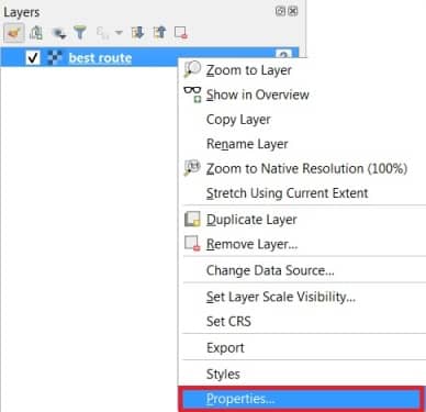
Open QGIS Software, Add data in the Layer panel. Right click the data file, select Properties.
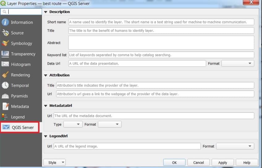
Layer Properties window is appear, select QGIS Server. Fill all the require blanks, then click OK.
Useful Web Clients
- QGIS Server Docs
- QWC2 GitHub
- Lizmap