ArcGIS Pro Overlay Analysis
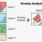
Overlay analysis in ArcGIS Pro is a technique for applying a common scale of values to diverse and dissimilar inputs to create an integrated analysis.
Overlay Analysis is a key spatial analysis method used to combine multiple layers of geographic data to discover relationships between them. It’s commonly used in land suitability analysis, impact assessments, site selection, and more.
They are two methods for performing overlay analysis—
- Feature overlay (overlaying points, lines, or polygons)
- Raster overlay
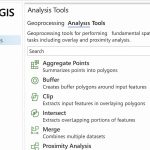
Overlay Tools & Toolset
The Overlay toolset contains tools to overlay multiple Feature classes.
| Tool | Description |
|---|---|
| Apportion Polygon | Summarizes the attributes of an input polygon layer based on the spatial overlay of a target polygon layer and assigns the summarized attributes to the target polygons. This process is typically known as apportioning or apportionment. |
| Count Overlapping Features | Generates planarized overlapping features from the input features. The count of overlapping features is written to the output features. |
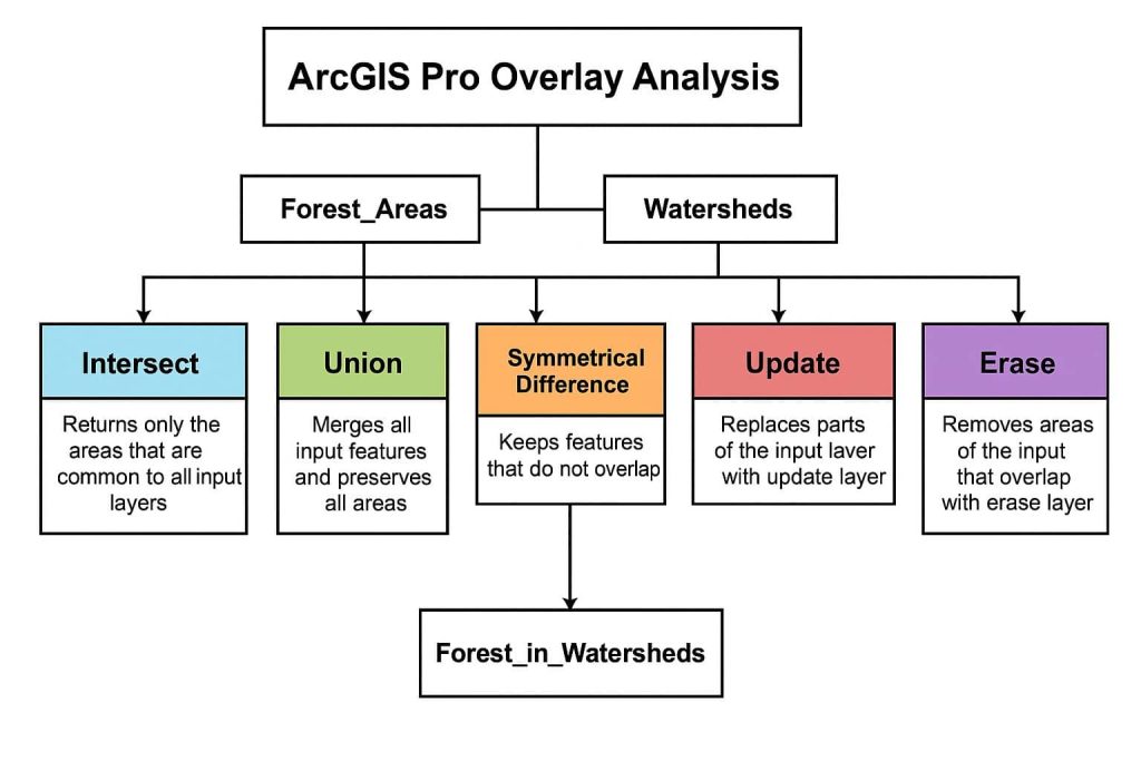
| Erase | Creates a feature class by overlaying the input features with the erase features. |
| Identity | Computes a geometric intersection of the input features and identity features. |
| Intersect | Computes a geometric intersection of the input features. Features or portions of features that overlap in all layers or feature classes will be written to the output feature class. |
| Remove Overlap (multiple) | Removes overlap between polygons contained in multiple input layers. |
| Spatial Join | Joins attributes from one feature to another based on the spatial relationship. The target features and the joined attributes from the join features are written to the output feature class. |
| Symmetrical Difference | Computes a geometric intersection of the input and update features, returning the input features and update features that do not overlap. |
| Union | Computes a geometric union of the input features. All features and their attributes will be written to the output feature class. |
| Update | Computes the geometric intersection of the input features and update features. |
Overlay Layers
The Overlay Layers tool requires two inputs: i) Input layer, and ii) Overlay layer.
The availability of overlay method options depends on whether the input and overlay layers are points, lines, or polygon (areas).
| Overlay Method | Input Layer | Overlay Layer |
|---|---|---|
| Intersect | Points, lines, or areas | Points, lines, or areas |
| Union | Areas | Areas |
| Erase | Areas | Points, lines, or areas |