Geoprocessing in QGIS
You can use Geoprocessing Tools in QGIS to perform spatial operations.
Geoprocessing Tools
Open the Geoprocessing Tools in QGIS;
In the Toolbar menu, click on Vector , select Geoprocessing Tools, and see all the available Geoprocessing Tools.
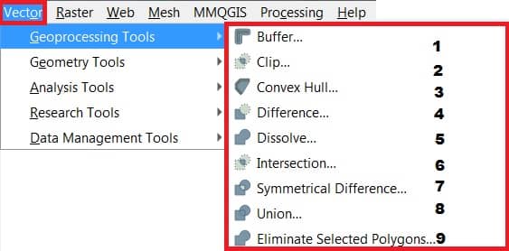
| Sl No. | Tool | Purpose |
|---|---|---|
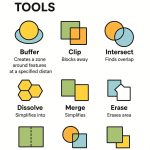
| 1 | Buffer | Create buffer around features based on fixed distance based on distance field. |
| 2 | Clip | Overlay layers such that output contains areas that intersect the clip layer. |
| 3 | Convex hull | Create minimum convex hull for an input layer, or based on an ID field. |
| 4 | Difference | Overlay layers such that output contains areas not intersecting the clip layer. |
| 5 | Dissolve | Merge features based on input field. All features with identical input values are combined to form one single feature. |
| 6 | Intersect | Overlay layers such that output contains areas where both layers intersect. |
| 7 | Symmetrical difference | Overlay layers such that output contains those areas of the input and difference layers that do not intersect. |
| 8 | Union | Overlay layers such that output contains intersecting and non-intersecting areas. |
| 9 | Eliminate sliver polygons | Merges selected features with the neighboring polygon with the largest area or largest common boundary. |