Overview of Garmin eTrex GPS
Garmin eTrex retains the core functionality, rugged construction, affordability and long battery life for the most dependable GPS device available. The Garmin improved the user interface and added a worldwide Basemap, paperless geocaching and support for spine-mounting accessories.
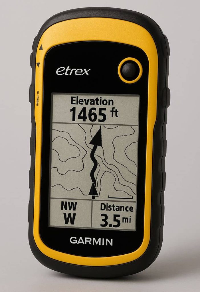
The Garmin eTrex is a well-known series of handheld GPS devices designed for outdoor activities such as hiking, geocaching, and field data collection in GIS and Remote Sensing. It’s popular due to its ruggedness, simplicity, and reliability.
Key Features of Garmin eTrex
| Feature | Description |
|---|---|
| Compact & Rugged Design | Durable and water-resistant (IPX7), ideal for outdoor use. |
| GPS & GLONASS Support | Uses multiple satellite systems for better accuracy in challenging environments (forests, valleys, etc.). |
| Battery Life | Long-lasting, often 25+ hours on 2 AA batteries. |
| Display | 2.2″ sunlight-readable screen (monochrome in eTrex 10, color in eTrex 22x/32x). |
| Waypoints & Routes | Can store thousands of waypoints and hundreds of routes. |
| Mapping Capability | Base models (e.g., eTrex 10) have basic maps; higher models support TopoActive maps and custom map loading. |
| Data Transfer | USB connection; some models support Bluetooth or ANT+ for sensor pairing. |
| Geocaching-friendly | Paperless geocaching support with GPX files. |
How to Use a Garmin eTrex
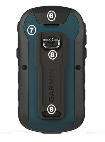
Device Overview
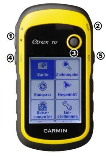
➊ Zoom keys
➋ Back key
➌ Thumb Stick
➍ Menu key
➎ Backlight key
➏ Mini-USB port (under weather cap)
➐ Battery cover
➑ Battery cover locking ring
➒ Mounting spine
Using the eTrex Keys
- Move the Thumb Stick up, down, left, and right to highlight menu selections or to move around the map.
- Press the center of the Thumb Stick to select the highlighted item.
- Now Press back to move back one step in the menu structure.
- Press menu to display a list of commonly-used functions for the current page. Press menu twice to access the main menu from any page.
- Press ▲ and ▼ to zoom in and out on the map.
Installing Batteries
The device operates on two AA batteries. You can use alkaline, NiMH, or lithium batteries. Use NiMH or lithium batteries for best results.
- Turn the D-ring counter-clockwise, and pull up to remove the cover.
- Replace the battery cover, and turn the D-ring clockwise.
- Hold
- Select Setup > System > Battery Type.
- Select Alkaline, Lithium, or Rechargeable NiMH
Turn on the device
Click Hold to Turn on your device.
Acquire Satellites
After the device is turned on, it begins acquiring satellite signals. If the sky are clear, is good for acquire satellite signals.
When the GPS bars on the backlight page are solid green, now your device has acquired satellite signals. The time and date are set automatically based on the GPS position.
Register the device
The Registering your device, visit to Garmin official website.
Waypoints, Routes, and Tracks
Make a Waypoint
1. Select Mark Waypoint.
2. Select an option:
• To save the waypoint without changes, select Done.
• To make changes to the waypoint, select an item to edit, and select Done.
3. To Finding a Waypoint, select Where To? > Waypoints, then select a waypoint,
4. To Editing a Waypoint, select Waypoint Manager > waypoint, select an item to edit, Enter the new information, click Done.
5. For Deleting a Waypoint, select Waypoint Manager > waypoint, select menu > Delete > Yes.
Create a Route
1. Select Route Planner > Create Route > Select First Point.
2. Then select a category.
3. Select the first point in the route.
4. Select Use > Next Point.
5. Repeat steps 2–4 until the route is complete.
6. Select back to save the route.
Record a Track
1. Recording Track Logs,Select Setup > Tracks > Track Log.
2. Select Record, Do Not Show or Record, Show On Map. If you select Record, Show On Map, a line on the map indicates your track.
3. Select Record Method.
• To record tracks at a variable rate that creates an optimum representation of your tracks,
select Auto.
• To record tracks at a specified distance, select Distance, and record tracks at a specified
time, select Time
4. Select Record Interval.
• Select an option to record tracks more or less often.
Using the Most Often interval provides the most track detail, but fills up the device memory quicker.
• Enter a time or distance, and select Done.
Navigate to a destination
You can navigate a route, a track, to a waypoint,
1. Select Where To?.
2. Then select a category.
3. Now Select a destination, select Go.
The map page opens with your route marked with a magenta line.
4. Navigate using the Map or Compass.
Navigation Map
Browsing the Map;
- Select Map.
- Select one or more options:
- Use the Thumb Stick to pan the map to view different areas. Select ▲ and ▼ to zoom in and out of the map.
- Select a location on the map, and the bar at the top of the screen shows information about the selected location.
Compass
Calibrate the compass;;
1. Select Compass > menu > Calibrate Compass > Start.
2. Turn until points toward the top of the compass, and continue moving in that direction to the destination.
Popular eTrex Models
| Model | Highlights |
|---|---|
| eTrex 10 | Entry-level; monochrome display; no detailed maps; good for basic navigation. |
| eTrex 22x | Color screen; preloaded TopoActive maps; microSD slot for extra maps. |
| eTrex 32x | All features of 22x + 3-axis compass and barometric altimeter. |
| eTrex SE (2023) | Newer budget model; long battery life; Bluetooth; simplified interface. |