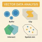
Proximity Analysis
What is Proximity Analysis?
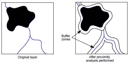
Proximity analysis determines which pixels of a layer are located at specified distances from pixels in a certain class or classes. A new thematic layer is created, which is categorized by the distance of each pixel from specified classes of the input layer. This new file then becomes a new layer of the database and provides a Buffer zone around the specified class or classes.
Proximity Analysis Toolset ArcGIS
The Proximity toolset contains tools that are used to determine the proximity of features within one or more feature classes or between two Feature classes.
| Tool | Description |
|---|---|
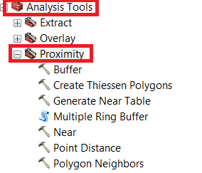
| Buffer | Creates buffer polygons around input features to a specified distance. |
| Create Thiessen Polygons | Creates Thiessen polygons from point features. Thiessen polygon is closer to its associated point than to any other point input feature. |
| Generate Near Table | Generate Near Table writes results to a new stand-alone table and supports finding more than one near feature. |
| Graphic Buffer | A number of cartographic shapes are available for buffer ends (caps) and corners (joins) when the buffer is generated around the feature. |
| Multiple Ring Buffer | These buffers can optionally be merged and dissolved using the buffer distance values to create non-overlapping buffers. |
| Near | Calculates distance and additional proximity information between the input features and the closest feature in another layer or feature class. |
| Point Distance | Determines the distances from input point features to all points in the near features within a specified search radius. |
| Polygon Neighbors | Creates a table with statistics based on polygon contiguity (overlaps, coincident edges, or nodes). |
Proximity Analysis Tool
Proximity analysis tools can be divided into two categories depending on the type of input the tool accepts: Features and Rasters.
Proximity Tools
Raster Distance Tools
| Tool | Toolset | Description |
|---|---|---|
| Euclidean Distance | Spatial Analyst/Distance | Calculates the distance to the nearest source for each cell. |
| Euclidean Allocation | Spatial Analyst/Distance | Gives each cell the identifier of the closest source. |
| Euclidean Direction | Spatial Analyst/Distance | Calculates the direction to the nearest source for each cell. |
| Cost Distance | Spatial Analyst/Distance | Calculates the distance to the nearest source for each cell, minimizing cost specified in a cost surface. |
| Cost Allocation | Spatial Analyst/Distance | Gives each cell the identifier of the closest source, minimizing cost specified in a cost surface. |
| Cost Path | Spatial Analyst/Distance | Calculates the least-cost path from a source to a destination, minimizing cost specified in a cost surface. |
| Cost Back Link | Spatial Analyst/Distance | Identifies for each cell the neighboring cell that is on the least-cost path from a source to a destination, minimizing cost specified on a cost surface. |
| Path Distance | Spatial Analyst/Distance | Calculates the distance to the nearest source for each cell, minimizing horizontal cost specified in a cost surface, as well as the terrain-based costs of surface distance and vertical travel difficulty specified by a terrain raster and vertical cost parameters. |
| Path Distance Allocation | Spatial Analyst/Distance | Gives each cell the identifier of the closest source, minimizing horizontal cost specified in a cost surface, as well as the terrain-based costs of surface distance and vertical travel difficulty specified by a terrain raster and vertical cost parameters. |
| Path Distance Back Link | Spatial Analyst/Distance | Identifies for each cell the neighboring cell that is on the least-cost path from a source to a destination, minimizing horizontal cost specified in a cost surface, as well as the terrain-based costs of surface distance and vertical travel difficulty specified by a terrain raster and vertical cost parameters. |
| Corridor | Spatial Analyst/Distance | Calculates the sum of accumulative cost for two input cost distance rasters. The cells below a given threshold value define an area, or corridor, between sources where the two costs are minimized. |
| Surface Length | 3D Analyst/Functional Surface | Calculates the length of line features across a surface, accounting for terrain. |
Vector Distance Tools
| Tool | Toolset | Description |
|---|---|---|
| Buffer | Analysis toolbox/Proximity | Creates new feature data with feature boundaries at a specified distance from input features |
| Near | Analysis toolbox/Proximity | Adds attribute fields to a point feature class containing distance, feature identifier, angle, and coordinates of the nearest point or line feature |
| Select By Location | Data Management toolbox/Layers and Table Views | Selects features from a target feature class within a given distance of (or using other spatial relationships) the input features |
| Create Thiessen Polygons | Analysis toolbox/Proximity | Creates polygons of the areas closest to each feature for a set of input features |
| Make Closest Facility Layer | Network Analyst/Analysis | Sets analysis parameters to find the closest location or set of locations on a network to another location or set of locations |
| Make Service Area Layer | Network Analyst/Analysis | Sets analysis parameters to find polygons that define the area within a given distance along a network in all directions from one or more locations |
| Make Route Layer | Network Analyst/Analysis | Sets analysis parameters to find the shortest path among a set of points |
| Make OD Cost Matrix Layer | Network Analyst/Analysis | Sets analysis parameters to create a matrix of network distances among two sets of points |
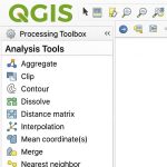
How to Open Proximity Analysis Tool in ArcGIS
You are already open ArcMap in your Ststem;
Open ArcToolbox, go to Analysis Tools > Proximity