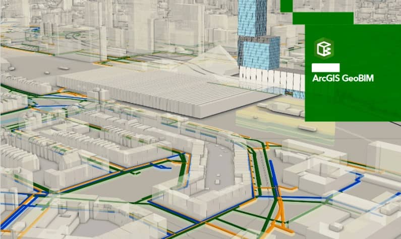
ArcGIS GeoBIM
What is ArcGIS GeoBIM?
ArcGIS GeoBIM (Geographic Building Information Modeling) easy-to-use web-based application to explore geospatial context for building information model, of digital transformation in the architecture, engineering, and construction (AEC) industry.
Geographic information system (GIS) and Building Information Modeling (BIM) integration isn’t new in the AEC industry. ArcGIS GeoBIM is Released for widespread use as of October 4, 2021.
GeoBIM enables us to provide web-based access to anyone on the project team with ease of entry and intuitive tools. It’s delivers an innovative, easy-to-use web-based experience for teams to explore and collaborate on BIM projects and issues, using data from multiple systems in a geospatial context.
Benefits
GIS and BIM project content through a common web-based app experience:
- Reuse GIS and BIM data on multiple projects in the same geographic region and reduce data duplication and acquisition costs.
- ArcGIS GeoBIM maintains dynamic links to documents and models in the Autodesk Construction Cloud so that when new versions are available, they can be incorporated with existing and new project information.
- GeoBIM includes an easy-to-use project index that enables the user to quickly access all data tied to the project.
How GeoBIM Works?
- Projects and assets in context– view, manage, and access project data across multiple locations.
- Projects organized– access GIS and BIM data in a single user experience.
- Reduce costly model conversions– created and reduce the need to convert models throughout the project life cycle.
- Communicate project performance– visualize activities for project data, such as timelines, issue completion, and asset locations, etc.
Build better with BIM and GIS Cloud Collaboration
Esri and Autodesk industry leaders that are working together to put GIS and BIM data at the center of projects. Two leading industries joined and forces to develop.
It offered; BIM and GIS could collaboration, connect location information, modeling data, and collaborative workflows in one view of real-world context. Increase project collaboration from highways, buildings, and more by saving time and improving your team’s decision-making.
Plan, Design, Build, and Operate
This cloud-based technology, help your teams visualize impact to the surrounding environment along with all other necessary components of project workflow. With BIM and GIS Cloud Collaboration, you’ll gain critical insight into the challenges of tomorrow while leveraging the core tools your users already know.