ArcGIS

ArcGIS Developed by ESRI,  use for mapping and analytics platform.

ArcMap Provides GIS and Mapping Products- ArcGIS Online, ArcGIS Pro, ArcGIS Enterprise, ArcGIS for Developers.

In below list of ArcGIS Tutorial.

Parcel Fabric

ArcGIS Parcel Fabric Tutorial

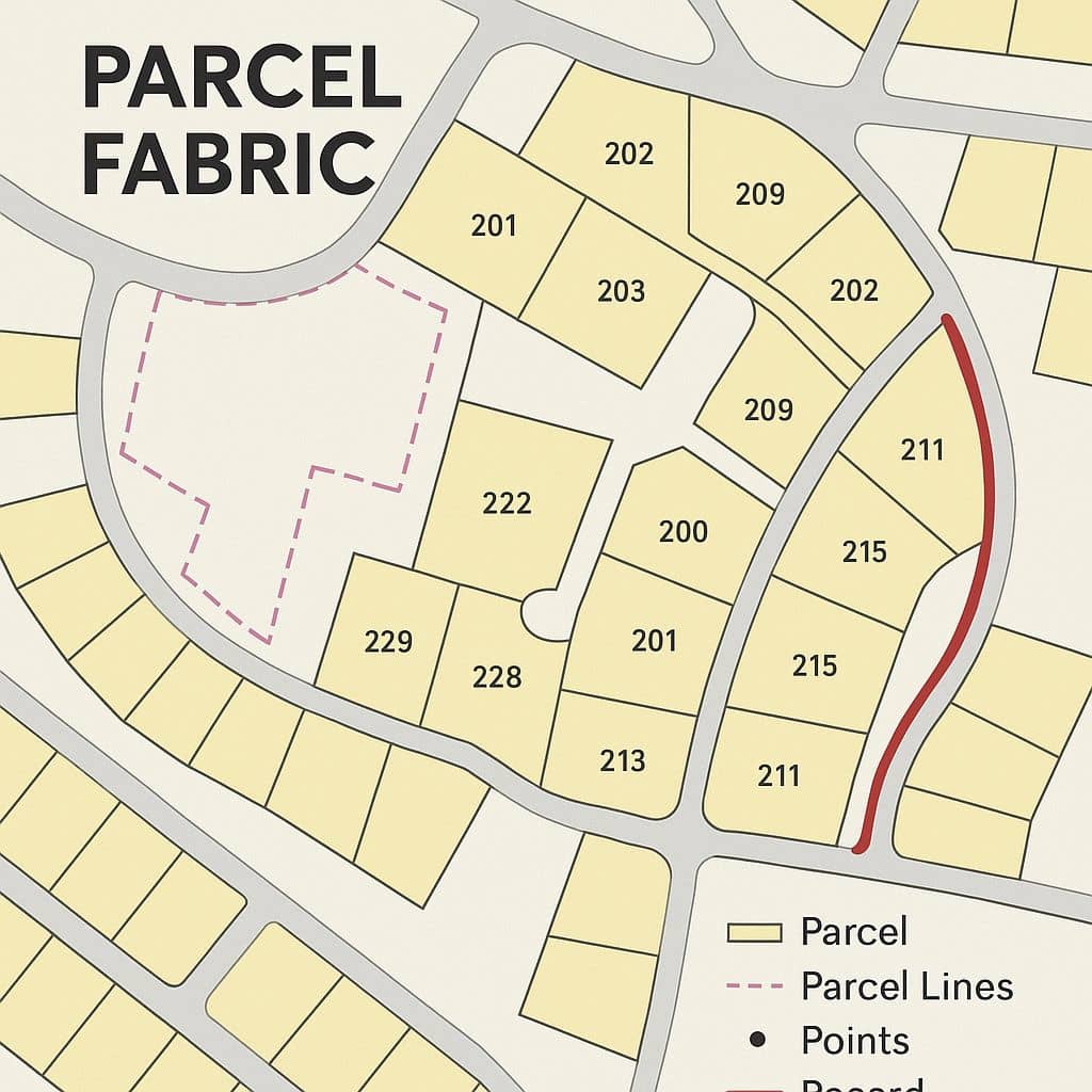
ArcGIS Parcel Fabric Tutorial In this tutorial, opening and editing parcel fabric dataset in ArcGIS. What is Parcel Fabric? A parcel fabric is a continuous surface of connected parcels/parcel network. Parcels are made up of point, line, and polygon features. Components Component Function Parcels Polygon features representing property boundaries. Parcel Types Different classifications like lots, […]

ArcGIS Parcel Fabric Tutorial Read More »

Feature Class ArcGIS

Feature Class in ArcGIS What is Feature Class? Feature classes are spatial representation, such as points, lines, or polygons, and a common set of attribute columns. For example, a Point feature class for representing placemark, such as School, Hospital. The four most commonly used feature classes are Point, Line, Polygon, and Annotation. Types of Feature

Feature Class ArcGIS Read More »

ArcGIS Maps

ArcGIS Maps

ArcGIS Maps ArcGIS Maps is an interactive display of Geographic Information on the Earth. The map has a topographic Basemap that includes cities, roads, and buildings overlaid on land cover and shaded relief imagery. You can create map in ArcGIS Desktop, and also ArcGIS Online Web server. Map Viewer or Map Viewer Classic, the map

ArcGIS Maps Read More »

ArcGIS Pro Mac

ArcGIS Pro Mac Run ArcGIS Pro on Mac Allows Boot Camp to install Windows Desktop Operating System (OS) on a hard disk partition on the Mac hard drive. This allows run to ArcGIS Pro run natively on a Windows partition on the Mac. Minimum Hardware Requirements The minimum hardware requirement to install ArcGIS Pro on

ArcGIS Pro Mac Read More »

ArcGIS Field Maps

ArcGIS Field Maps

What is ArcGIS Field Map? ArcGIS Field Maps is the field app, powered by field maps, that streamlines the critical workflows field personnel use every day. Field Maps is a mobile solution that allows to capture data, perform inspections, take notes, and share information with the office. Use the Field Maps web app to configure

ArcGIS Field Maps Read More »

Scroll to Top