ArcGIS Pro Image Analyst
ArcGIS Image Analyst for ArcGIS Pro provides tools for advanced image interpretation, exploitation, and geospatial analysis on an array of imagery modalities.
Image Analyst Extension
The ArcGIS Pro Image Analyst extension provides functions, tools, and capabilities for image and geospatial analysis focus on:
- Image interpretation and exploitation
- Creation of information products from imagery
- Advanced raster and image analysis workflows
- Advanced interpretation and measurements from imagery
- Detailed feature compilation and measurement on stereo imagery
Image Analyst Toolbox
The ArcGIS Pro Image Analyst extension provides tools with which to analyze imagery data, and advanced image interpretation.
| Toolset | Description |
|---|---|
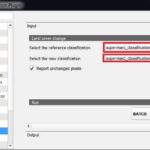
| Change Detection | The Change Detection tool-set contains tools that perform change detection between raster datasets. |
| Classification and Pattern Recognition | The classification and pattern recognition tools perform regression analysis and prepare segmented raster for use in creating classified raster datasets. |
| Deep Learning | The Deep Learning tool-set contains tools that detect specific features in an image and classify pixels in a raster dataset. |
| Extraction | The Extraction tool-set allows you to extract a subset of pixels from a raster by the pixels’ attributes or their spatial location. |
| Map Algebra | Map Algebra is a way to perform spatial analysis by creating expressions in an algebraic language. |
| Math | The Math tool-set contains tools that perform mathematical operations on raster. The tools are grouped into four main categories: Math Conditional Logical Trigonometric |
| Motion Imagery | The Motion Imagery tool-set contains tools for managing, processing, and analyzing motion imagery, including full motion video data. |
| Multidimensional Analysis | The Multidimensional Analysis tool-set contains tools for performing analysis on scientific data across multiple variables and dimensions. |
| Overlay | With the Overlay analysis tool-set you can weight and overlay several raster to create a single summary raster result. |
| Statistical | The statistical tools perform statistical operations on raster data. |
| Synthetic Aperture Radar | The Synthetic Aperture Radar tool-set contains tools that correct, process, and enable analysis of SAR data. |