Remote Sensing Specialist
Remote sensing specialist has a bachelor’s degree in environmental biology, geospatial intelligence analytics, geospatial science, and environmental chemistry degrees. Continuing higher education is highly recommended. A masters program in remote sensing or other geospatial technologies is suggested.
Remote sensing scientists use sensors to analyze data and solve regional, national and global
concerns. For examples, natural resource management, urban planning, and climate and weather prediction are applications of remote sensing. Many scientists develop new sensor systems, analytical techniques, or new applications for existing systems. Remote sensing scientists also process aerial or satellite imagery to create products like land cover maps.
Remote sensing specialists support scientists by designing and conducting remote sensing data gathering efforts. For example, they determine the best techniques, equipment, spectral band, and time of day for a particular mission. They may prepare flight plans, configure sensors, apply the techniques to collect data in the field, and process the resulting data.
If you’re interested in becoming a remote sensing specialist, one of the first things to consider, your education level. We’ve determined that 60% of remote sensing specialists have a bachelor’s degree. In terms of higher education levels, we found that 25% of remote sensing specialists have master’s degrees. Even though most remote sensing specialists have a college degree, it’s possible to become one with only a high school degree or General Educational Development.
Educational Background
Typically holds a degree in:
- Remote Sensing
- Geoinformatics
- Environmental Science
- Geography
- Earth/Atmospheric Sciences
Key Responsibilities
- Image Acquisition
- Collect data from satellites (e.g., Landsat, Sentinel, MODIS) or drones/UAVs.
- Work with different sensors: multispectral, hyperspectral, radar, thermal.
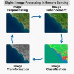
- Image Processing
- Perform corrections (radiometric, geometric).
- Enhance image quality for better interpretation.
- Conduct classification (supervised/unsupervised), NDVI, change detection, etc.
- Data Analysis & Interpretation
- Analyze land cover/use, vegetation health, water bodies, urban sprawl, etc.
- Detect environmental changes or hazards.
- GIS Integration
- Integrate remote sensing data with GIS for advanced spatial analysis and map creation.
- Reporting & Visualization
- Generate reports, thematic maps, and visualizations for decision-makers.
Tools & Software
- ERDAS IMAGINE
- ENVI
- QGIS / ArcGIS
- Google Earth Engine
- Python, R (for scripting and automation)
- MATLAB (sometimes for scientific image analysis)