Remote Sensing

Remote sensing (RS) is an art and science of obtaining information about physical characteristics of an area by measuring its reflected and emitted radiation at a distance to help of Satellite or Aircraft.

In below list of Remote sensing Analysis Tutorial.

Supervised Classification

Supervised Classification

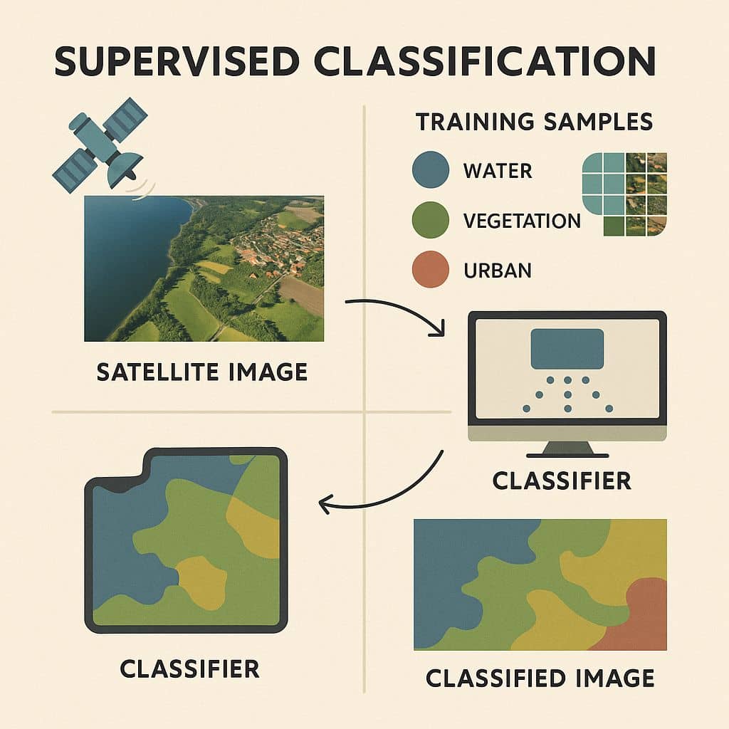
Supervised Classification using Erdas Imagine Software Supervised classification uses image pixels representing regions of known, homogenous surface composition ‘training areas’ to classify unknown pixels. A Supervised Classification describes information about the data of land use as well as land cover for any region. Soil type, Vegetation, Water bodies, Cultivation, etc. Supervised Training Supervised training is […]

Supervised Classification Read More »

DEM from Google Earth

Create DEM & Contour from Google Earth in ArcGIS In this Tutorial learn, how to Create Contour and DEM (Digital Elevation Models) from Google Earth with to help of ArcGIS Software. Digital Elevation Model (DEM) is an Elevation data to represent Terrain. Create DEM from Google Earth DEMs are used often in Geographic Information Systems (GIS) and are the most common

DEM from Google Earth Read More »

Aerial Photography

Aerial Photography

Aerial Photography What is Aerial Photography? Aerial photography is the process of taking photographs of the Earth’s surface from an elevated position, typically using aircraft, helicopters, balloons, blimps, dirigibles, rockets, parachutes. In recent times, using ‘Drone’ to capture Aerial Photographs. It plays a critical role in Remote Sensing, mapping, GIS, environmental monitoring, and urban planning. In Photographs the

Aerial Photography Read More »

Satellite Imagery Data Sources

Popular Sources to Download Free Satellite Imagery Data Some Authority websites is provided Satellite Imagery Data, it has been Landset, Elevation, Rader, Aerial Imagery, etc data.  Download Free Satellite Imagery Data Sources and use to your project. In Below list of best Satellite Imagery Data Sources sites. List of Satellite Imagery Data Source 1. Earth Explorer-

Satellite Imagery Data Sources Read More »

NDVI, NDBI, NDSI, SAVI

Pwrform NDVI, NDBI, NDSI, SAVI- Erdas Imagine NDVI The NDVI stand for Normalized Difference Vegetation Index, its describes the vegetation density and assessing changes in plant health. NDVI is calculated as a ratio between the red (R) and near-infrared (NIR). In this tutorial, learn how to apply the NDVI Formula and calculate vegetation patterns. Process of NDVI NDVI Formula (NIR – R)

NDVI, NDBI, NDSI, SAVI Read More »

Scroll to Top