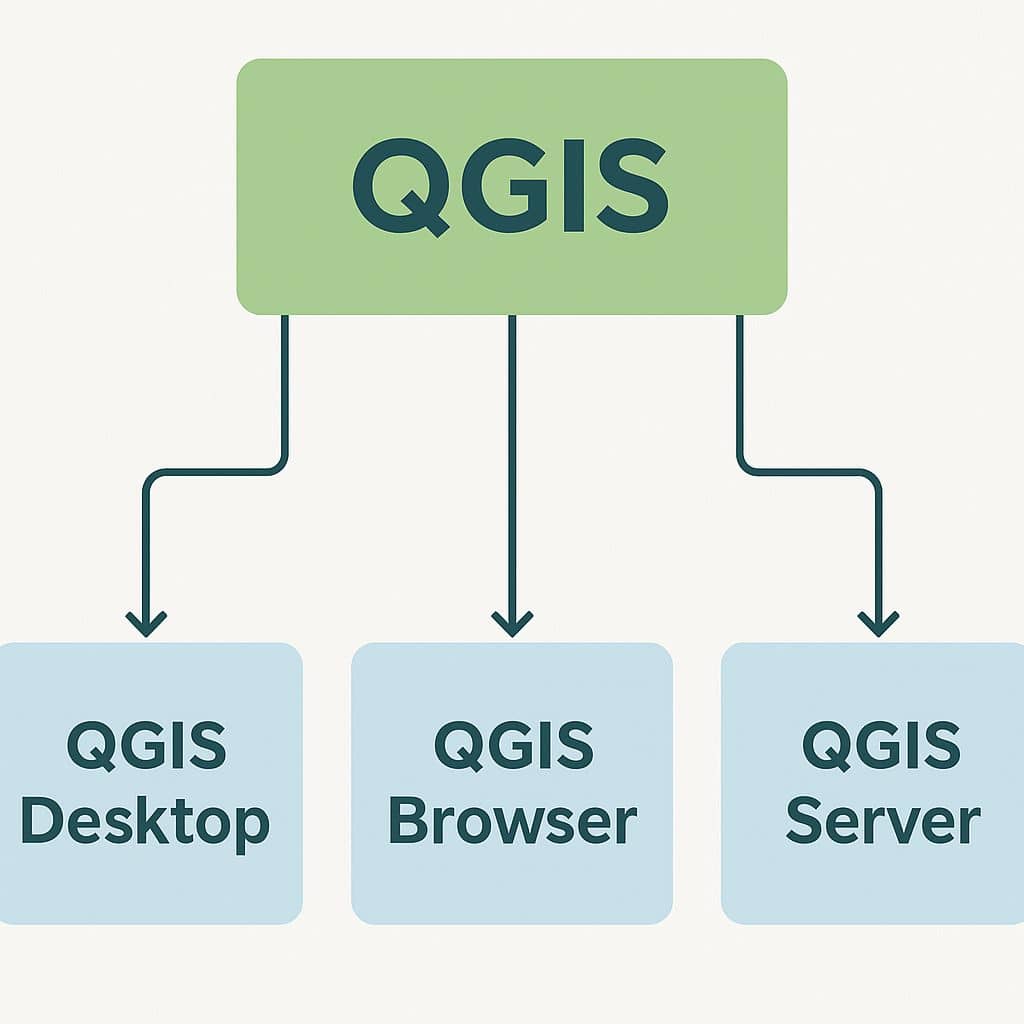
QGIS

QGIS is a Free and Open Source Geographic Information System (GIS) Softtware.

QGIS is available on Windows, macOS, Linux and Android

The current version is QGIS 3.10.2 ‘A Coruña’ and was released. Download and start in below QGIS Tutorial Basic.

In below list of QGIS Tutorial.

QGIS Server

QGIS Server

QGIS Server QGIS Server is an open-source WMS 1.3, WFS 1.0.0 and WCS 1 1.1.1, implements advanced cartographic features for thematic mapping. I6 is a FastCGI/CGI (Common Gateway Interface) application written in C++ that works together with a web server. It has Python plugin support allowing for fast and efficient development and deployment of new […]

QGIS Server Read More »

QGIS components

QGIS Software

What is QGIS? QGIS stand for Quantum GIS, it’s a Free and open-source GIS Software to perform GIS (Geographic Information System) application, that supports create, edit, visualize and analysis of Geo-spatial data. Uses of QGIS: Download QGIS Software The current version is of QGIS 3.44.0 ‘Solothurn’ has been released. Download QGIS Software. Core Components of

QGIS Software Read More »

QGIS Cloud

QGIS Online/ Cloud Tutorial QGIS Cloud is a platform that allows users to publish and share GIS projects created in QGIS. What is QGIS Cloud? QGIS Online/Cloud is one of the powerful WebGIS platform for publishing maps, data and services on the Internet. It is your personal Spatial Data Infrastructure (SDI) platform, to create and

QGIS Cloud Read More »

Layout QGIS

Map Layout- Print Composer – QGIS In this Tutorial Learn How to Create Map Layout in QGIS. The Print Composer provides growing layout and printing capabilities. It allows you to add elements such as the QGIS map canvas. Layout Features Text labels, images, legends, scale bars, basic shapes, arrows, attribute tables, and HTML frames. You can size, group,

Layout QGIS Read More »

Shapefiles

Shapefiles

Create a Shapefile in ArcGIS & QGIS In this Tutorial learn, how to create a Shapefiles or Vector file in ArcGIS and QGIS software. What is Shapefile? Shapefiles are simple, non-topological Vector format for storing the geometric location and attribute information of geographic features. Geographic features in a shapefile can be represented by points, lines,

Shapefiles Read More »

Scroll to Top