Map with Scale in GIS
What is Map Scale
Map scale is a statement that relates distance on a map to distance on the Earth’s surface. It is perhaps the most important information on a map, since the level of detail and map accuracy are both factors of the map scale.
Scale is directly related to the map extent, or the area of the Earth’s surface to be mapped. If a relatively small area is to be mapped, such as a neighborhood or subdivision, then the scale can be larger. If a large area is to be mapped, such as an entire continent, the scale must be smaller. Generally, the smaller the scale, the less detailed the map can be. As a rule, anything smaller than 1:250,000 is considered small-scale.
Illustration: Map with Scale
 ----------------------------
|                            |
|     [Map Features]        |
|                            |
|----------------------------

 Scale:
 0 km |––––––––|––––––––|––––––––|
       0       5       10      15
In GIS (Geographic Information Systems), map scale refers to the ratio between a distance on a map and the corresponding distance on the ground. It’s essential for interpreting spatial data accurately.
Types of Map Scales
Scale can be represented in several ways, including:
1. Verbal Scale (Statement Scale)
A verbal statement of scale describes the distance on the map to the distance on the ground. A verbal statement describing a scale of 1:1,000,000 is approximately 1 inch to 16 miles. The units on the map and on the ground do not have to be the same in a verbal statement. One-inch and 6-inch maps of the British Ordnance Survey are often referred to by this method (1 inch to 1 mile, 6 inches to 1 mile) (Robinson and Sale, 1969).
- Example: “1 cm = 1 km”
- Tells in words how much map distance equals real-world distance.
2. Representative Fraction (RF) Scale
Map Scale is often noted as a simple ratio or fraction called a representative fraction. A map in which one inch on the map equals 25,000 inches on the ground could be described as having a scale of 1:25,000 or 1/25,000. The units on both sides of the ratio must be the same.
- Example: 1:100,000
- Means 1 unit on the map represents 100,000 of the same units on the ground.
(1 cm = 1,000 m = 1 km)
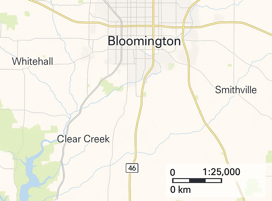
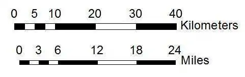
3. Graphic Scale (Bar Scale)
A scale bar is a graphic annotation element that describes map scale. It shows the distance on paper that represents a geographical distance on the map. Maps often include more than one scale bar to indicate various measurement systems, such as kilometers and miles.
- A visual bar on the map that shows distances.
- Useful because it stays accurate even if the map is resized.
Common Map Scales
| Map Scale | 1/40 inch represents | 1 inch represents | 1 centimeter represents | 1 mile is represents | 1 kilometer is represents |
|---|---|---|---|---|---|
| 1:2,000 | 4.200 ft | 56.000 yd | 20.000 m | 31.680 in | 50.00 cm |
| 1:5,000 | 10.425 ft | 139.000 yd | 50.000 m | 12.670 in | 20.00 cm |
| 1:10,000 | 6.952 yd | 0.158 mi | 0.100 km | 6.340 in | 10.00 cm |
| 1:15,840 | 11.000 yd | 0.250 mi | 0.156 km | 4.000 in | 6.25 cm |
| 1:20,000 | 13.904 yd | 0.316 mi | 0.200 km | 3.170 in | 5.00 cm |
| 1:24,000 | 16.676 yd | 0.379 mi | 0.240 km | 2.640 in | 4.17 cm |
| 1:25,000 | 17.380 yd | 0.395 mi | 0.250 km | 2.530 in | 4.00 cm |
| 1:31,680 | 22.000 yd | 0.500 mi | 0.317 km | 2.000 in | 3.16 cm |
| 1:50,000 | 34.716 yd | 0.789 mi | 0.500 km | 1.270 in | 2.00 cm |
| 1:62,500 | 43.384 yd | 0.986 mi | 0.625 km | 1.014 in | 1.60 cm |
| 1:63,360 | 0.025 mi | 1.000 mi | 0.634 km | 1.000 in | 1.58 cm |
| 1:75,000 | 0.030 mi | 1.180 mi | 0.750 km | 0.845 in | 1.33 cm |
| 1:80,000 | 0.032 mi | 1.260 mi | 0.800 km | 0.792 in | 1.25 cm |
| 1:100,000 | 0.040 mi | 1.580 mi | 1.000 km | 0.634 in | 1.00 cm |
| 1:125,000 | 0.050 mi | 1.970 mi | 1.250 km | 0.507 in | 8.00 mm |
| 1:250,000 | 0.099 mi | 3.950 mi | 2.500 km | 0.253 in | 4.00 mm |
| 1:500,000 | 0.197 mi | 7.890 mi | 5.000 km | 0.127 in | 2.00 mm |
| 1:1,000,000 | 0.395 mi | 15.780 mi | 10.000 km | 0.063 in | 1.00 mm |
[Note : ft=feet, yd=yard, mi=mile, in=inch, m=meter, km=kilometer, cm=centimeter, mm=milimeter]
Importance of Map Scale
- Accurate distance measurement
- Helps in area calculation
- Assists in navigation and planning
- Crucial for remote sensing and GIS analysis
Using Scale in GIS Tools
| GIS Software | How to Use Scale |
|---|---|
| QGIS | View scale in bottom toolbar → Enter fixed scale in “Map Canvas” |
| ArcGIS | Set fixed scale in the map frame properties or in layout view |
| Google Earth Engine / Web Maps | Scale changes automatically with zoom |