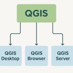
Summary: – GIS software comes in various forms, ranging from desktop applications like ArcGIS and QGIS to web-based platforms and mobile solutions. In this lesson, cover the best GIS Software, and their features, advantages and disadvantages.
A Complete Overview of GIS Software
GIS software is mainly used to work with spatial data—information that is linked to specific locations on the Earth’s surface. It allows users to collect data from sources like GPS, surveys, or remote sensing; store it in organized formats such as maps and databases; analyze it to identify patterns, relationships, or trends; and visualize the results through maps, charts, and graphs. This helps people make better decisions based on geographic information in fields like urban planning, agriculture, and disaster management. Examples: ArcGIS, QGIS, MapInfo Pro.
Broad Categorization of GIS Software
GIS software can be broadly categorized based on deployment model, licensing type, and functional platform.
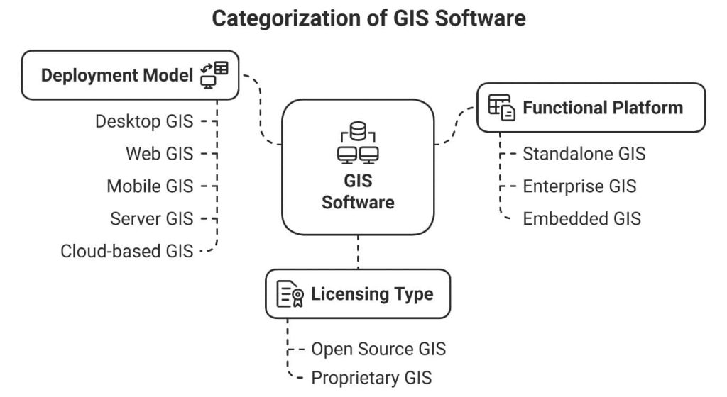
Based on Deployment Model
Remote Sensing (RS) and GIS software can be broadly categorized based on how and where they are deployed or accessed. The deployment model determines whether the software runs on a personal computer, across a network, in the cloud, or on mobile devices. Each model offers different advantages in terms of accessibility, scalability, performance, and user collaboration.
a) Desktop GIS:
Desktop GIS refers to GIS software that is installed directly on a personal computer or workstation. It provides a wide range of tools for performing advanced spatial analysis, editing geospatial data, producing detailed maps, and integrating with various databases. This type of GIS is particularly useful for professionals and analysts who need a powerful, standalone platform for in-depth spatial tasks. Desktop GIS supports both vector and raster data formats and allows users to carry out complex operations such as buffering, overlay analysis, and geostatistics (Longley et al., 2015). It is commonly used in fields like urban planning, environmental management, and infrastructure development. Popular
examples of desktop GIS software include ArcGIS Pro, QGIS, and MapInfo Professional (Lillesand et al., 2015).
b) Web GIS:
Web GIS is a type of GIS software that operates through web browsers and utilizes internet protocols to provide spatial data services and interactive mapping capabilities. Unlike desktop GIS, it does not require installation on a local machine and can be accessed from any device with an internet connection (Fu & Sun., 2011). Web GIS enables real-time data sharing, collaboration among multiple users, and broad public engagement, making it ideal for applications that require accessibility and communication across different locations. It is widely used for developing interactive maps, dashboards, and web applications that visualize spatial data for decision-making and public awareness. Examples
include ArcGIS Online, MapServer, GeoServer, and web mapping libraries like Leaflet and OpenLayers.
c) Mobile GIS:
Mobile GIS is using GIS technology on handheld devices like smartphones and tablets to collect, edit, and update geospatial data directly in the field. It supports real-time data capture using GPS and wireless networks, allowing seamless integration with office-based systems. Mobile GIS is commonly used in sectors such as utilities, agriculture, field surveying, and emergency response, so mobile GIS enhances efficiency and decision-making. Popular applications include Collector for ArcGIS, Survey123, and QField. Tsou (2004) states it extends GIS capabilities to field environments, improving spatial accuracy and real-time data access.
d) Server GIS:
Server GIS is GIS software installed on centralized servers to provide services like map rendering, spatial queries, and data processing to multiple users over a network. It supports enterprise-level operations by managing and sharing geographic data securely and efficiently across various locations. Server GIS is the backbone for Web GIS applications. It integrates with databases, cloud platforms, and enterprise systems, making it vital for large organizations such as government agencies and utilities. Popular Server GIS platforms include ArcGIS Enterprise, GeoServer, and MapServer, which offer web service configurations, user management, and workflow automation. As Peng and Tsou (2003) note, Server GIS enables distributed geographic information processing, which is essential for interoperable and service-oriented GIS systems.
e) Cloud-based GIS:
Cloud GIS delivers GIS services through internet-based cloud platforms, eliminating the need for local hardware by using scalable cloud infrastructure for on-demand access to geospatial data, processing, and applications. This approach reduces IT costs and increases accessibility for organizations of all sizes. Cloud GIS excels at big data analytics by providing unlimited storage and computing power, supports real-time collaboration for distributed teams, and integrates with technologies like machine learning and IoT. Popular platforms include Esri’s ArcGIS Online, Google Earth Engine, and
Amazon Web Services (AWS) for Geospatial. Goodchild (2010) notes that cloud computing has transformed GIS into a service-oriented architecture, democratizing geospatial technology and driving innovation.
Based on Licensing Type
GIS software can be broadly classified based on their licensing type, which determines how users can access, use, and share the software. This classification is important for organizations and individuals when choosing software that fits their budget, project needs, and technical requirements.
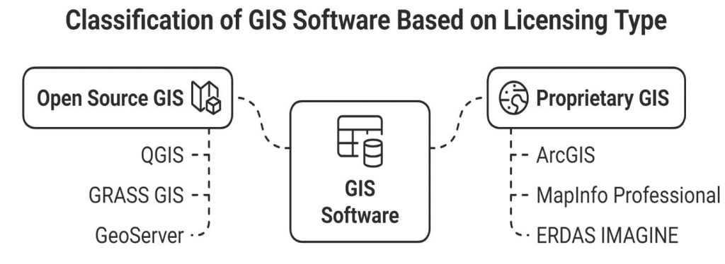
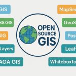
a) Open-Source GIS:
Open-Source GIS refers to GIS software that is freely available for use, modification, and distribution under open licenses. It is supported by global communities of developers and users who contribute to its improvement, ensuring continuous innovation and transparency. Open-source GIS is valued for its cost effectiveness, customization capabilities, and interoperability.
Steiniger and Bocher (2009) state that open-source GIS provides an accessible alternative to proprietary systems, fostering collaboration and technological advancement in geospatial sciences. Examples: QGIS, GRASS GIS, SAGA GIS, GeoServer
b) Proprietary (Commercial) GIS:
Proprietary GIS refers to commercial GIS software developed and maintained by private companies, requiring paid licenses or subscriptions. These platforms offer advanced tools, regular updates, technical support, and extensive documentation, making them ideal for professional and enterprise use.
Notable examples include ArcGIS by Esri (mapping and spatial analysis), MapInfo Professional by Precisely (business and location analytics), and ERDAS IMAGINE by Hexagon Geospatial (remote sensing and raster processing). These tools are widely adopted for their robust features and integration capabilities. Maguire and Longley (2005) noted that proprietary GIS systems have significantly contributed to mainstream GIS adoption by offering standardized, user-friendly solutions across various industries.
Based on Functional Platform
This refers to the type of system or environment where the software runs and how individuals or organizations use it.
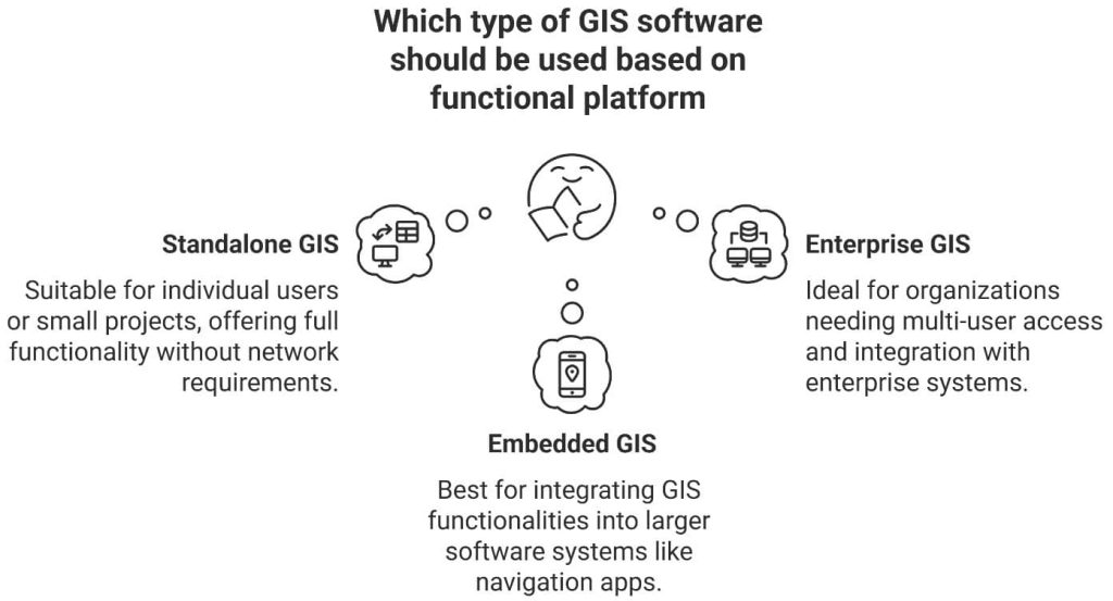
a) Standalone GIS: It is installed and used on a single computer by individual users and is suitable for personal or small-scale projects. It offers complete functionality without requiring network connectivity or multi-user access. Tools like QGIS or ArcGIS Desktop are commonly used in this mode.
b) Enterprise GIS: Enterprise GIS is integrated within an organization’s infrastructure, providing multi-user access, centralized data management, and integration with enterprise databases and systems (e.g., ERP, CRM). It supports collaboration and large-scale operations. Platforms like ArcGIS Enterprise and GeoServer are typical examples.
c) Embedded GIS: refers to functionalities built into larger software systems, such as navigation applications, logistics platforms, or customer relationship management (CRM) tools. Examples include Google Maps API in mobile apps or Mapbox SDK embedded in web platforms.
According to (Longley et al., 2015), these GIS deployments cater to different user needs, from individual spatial analysis to complex organizational workflows. It is incorporated into larger software systems (e.g., navigation apps, CRM systems).
List of Top 10 GIS Software’s
1. ArcGIS Pro
ArcGIS Pro, the powerful, modern Professional desktop GIS application from ESRI, ArcGIS Pro offers 2D, 3D, and 4D data analytics.

- Developer: Esri
- Platform: Windows
- Key Features: 2D/3D mapping, ModelBuilder, ArcPy, integrated with ArcGIS Online
- Applications: Urban planning, environmental monitoring, disaster management
- Strengths: Modern UI, robust tools, strong support, cloud integration
- Limitations: Expensive licensing, high system requirements
| Pros | Cons |
|---|---|
| ✅ Modern, user-friendly interface with ribbon UI. ✅ Integrated 2D and 3D visualization. ✅ Strong support for Python (ArcPy) and ModelBuilder. ✅ Seamless integration with ArcGIS Online and enterprise geodatabases. ✅ Frequent updates and strong customer support. | ❎ Expensive licensing. ❎ High system requirements. ❎ Proprietary software—limited flexibility for customization without Esri tools. |
Review: ArcGIS Pro Tutorial.
2. ArcGIS Desktop
ArcGIS is a foundational piece for GIS professionals to create, analyze, manage, and share geographic information. ArcGIS Desktop allows to create maps, performs spatial analysis, and manages data.
- Developer: Esri
- Platform: Windows
- Key Features:
- Comprehensive GIS tools
- Spatial analysis, 3D GIS, web GIS
- Extensive support and documentation
- Applications: Urban planning, environmental management, utilities
- Strengths: Industry standard, rich ecosystem
- Limitations: Costly licensing, high system requirements
| Pros | Cons |
|---|---|
| ✅ Proven, mature platform with wide user base. ✅ Extensive tools and extensions for spatial analysis. ✅ Compatibility with a wide range of data formats. | ❎ Legacy software—Esri is phasing it out in favor of ArcGIS Pro. ❎ Clunky interface by modern standards. ❎ No native 3D integration. |
Review: ArcGIS Desktop Tutorial.
3. QGIS
QGIS is a user friendly Free and Open Source Geographic Information System (GIS). QGIS licensed under the GNU (General Public License), it’s an official project of the Open-Source Geo-Spatial Foundation (OSGeo).
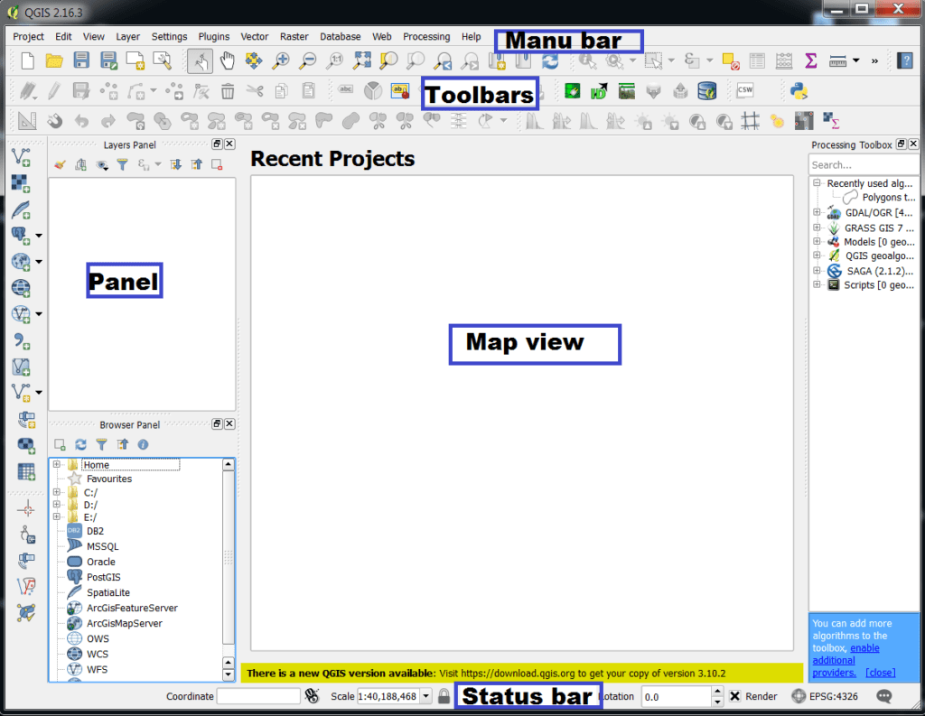
- Developer: OSGeo (Open-Source Community)
- Platform: Windows, Linux, macOS
- Key Features:
- Open-source alternative to ArcGIS
- Plugin support
- Supports most geospatial file formats
- Applications: Academic research, NGO work, planning
- Strengths: Free, highly customizable
- Limitations: Some plugins may lack documentation
| Pros | Cons |
|---|---|
| ✅ Open-source and free to use. ✅ Active community and frequent updates. ✅ Highly customizable with plugins. ✅ Good integration with databases (PostGIS, SpatiaLite). ✅ Strong Python support (PyQGIS). | ❎ Some plugins may be unstable or poorly documented. ❎ May lack enterprise-grade support and polish compared to Esri. ❎ Steeper learning curve for some advanced tools. |
Review: QGIS Tutorial.
4. GeoMedia
GeoMedia is a powerful, flexible GIS management platform Developed by Hexagon Geospatial. GeoMedia is a single unified map view for efficient processing, analysis, presentation, and sharing data, and provides simultaneous access to Geospatial Data.
- Developer: Hexagon Geospatial
- Platform: Windows
- Key Features: Real-time data access, strong DBMS support, advanced analysis
- Applications: Utilities, transportation, government GIS
- Strengths: Data integration, DB-driven workflows
- Limitations: Less intuitive UI, lower community support
| Pros | Cons |
|---|---|
| ✅ Strong analytical tools. ✅ Good integration with enterprise databases. ✅ Real-time data support. ✅ Useful in infrastructure and public sector applications. | ❎ Proprietary and costly. ❎ Less community support compared to Esri and QGIS. ❎ Outdated interface and less intuitive for new users. |
Review: GeoMedia Tutorial.
5. MapInfo Pro
MapInfo Pro is a complete, desktop mapping solution for the Geographic Information System (GIS), to visualize, analyze, edit, interpret, and output data. It’s helps you to better understand visualize data through map symbols, themes, and labels.
- Developer: Precisely (formerly Pitney Bowes)
- Platform: Windows
- Key Features: Thematic mapping, SQL support, business mapping tools
- Applications: Retail analysis, logistics, site selection
- Strengths: Fast rendering, business intelligence integration
- Limitations: Limited raster tools, lower flexibility
| Pros | Cons |
|---|---|
| ✅ User-friendly interface. ✅ Strong in thematic mapping and spatial querying. ✅ Good integration with tabular business data. ✅ Fast performance on large datasets. | ❎ Limited raster processing capabilities. ❎ Fewer advanced spatial tools than Esri or QGIS. ❎ Smaller user community. |
Review: MapInfo Pro Tutorial.
6. Global Mapper
Global Mapper is a cutting-edge GIS software Developed by Blue Marble Geographics. It’s provides both novice and experienced geospatial professionals with a comprehensive array of spatial data processing tools. Global Mapper Supports more than 300 spatial data formats.
- Developer: Blue Marble Geographics
- Platform: Windows
- Key Features: LiDAR support, terrain analysis, wide format compatibility
- Applications: Forestry, mining, surveying, 3D visualization
- Strengths: Affordable, lightweight, versatile
- Limitations: Limited cartography, basic database handling
| Pros | Cons |
|---|---|
| ✅ Supports 300+ formats. ✅ Strong in terrain and LiDAR data processing. ✅ Affordable one-time license. ✅ Easy to use for beginners and professionals. | ❎ Weaker in database and cartographic tools. ❎ Limited vector editing and analysis compared to others. ❎ Not as customizable as open-source tools. |
Review: Global Mapper Tutorial.
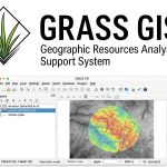
7. GRASS GIS
GRASS GIS is a free Geographic Information System (GIS) software used for for terrain and ecosystem modeling, hydrology, visualization of raster and vector data, management and analysis of geo-spatial data, also processing of satellite and aerial imagery.
- Developer: Open Source Geospatial Foundation (OSGeo)
- Platform: Cross-platform
- Key Features: Raster and vector data processing o Terrain analysis, hydrological modeling Scripting support with Python
- Applications: Ecology, hydrology, agriculture
- Strengths: Powerful analytical capabilities
| Pros | Cons |
|---|---|
| ✅ Open-source and powerful for raster and geospatial modeling. ✅ Excellent for scientific research and time-series analysis. ✅ Robust scripting via Bash and Python. | ❎ Steep learning curve. ❎ Outdated GUI (though improving). ❎ Not as intuitive or beginner friendly as QGIS or ArcGIS Pro. |
Review: GRASS GIS Tutorial.
8. gvSIG
The gvSIG is a open source professionals geo-matics network. It’s uses on spatial data infrastructures, mobile solutions and sectoral solutions.
- Developer: gvSIG Association
- Platform: Windows, macOS, Linux
- Key Features: 2D/3D views, CAD tools, mobile version
- Applications: Urban planning, civil engineering, public GIS
- Strengths: Open source, multilingual, customizable
- Limitations: Slower updates, small community
| Pros | Cons |
|---|---|
| ✅ Open-source and multilingual. ✅ Good integration with spatial databases. ✅ Mobile and 3D versions available. | ❎ Smaller community and limited resources/tutorials. ❎ Fewer plugins and tools than QGIS. ❎ Slower development cycle. |
Review: gvSIG Tutorial.
9. ILWIS
ILWIS (The Integrated Land and Water Information System) is a remote sensing and GIS software which integrates image and it’s delivering a wide range of features including import/export, digitizing, analysis and display of data, as well as production of quality maps.
- Developer: ITC, University of Twente
- Platform: Windows
- Key Features: GIS and remote sensing integration of Image classification and Geo statistics
- Applications: Land management, hydrology, environment
- Strengths: Freeware, easy interface
- Limitations: Outdated interface, fewer updates
| Pros | Cons |
|---|---|
| ✅ Combines GIS and remote sensing. ✅ Good for image processing and land cover mapping. ✅ Free and open source. | ❎ Outdated interface. ❎ Limited vector capabilities. ❎ Not actively developed or supported as robustly as others. |
Review: ILWIS Tutorial.
10. AutoCAD Map 3D
The AutoCAD Map 3D is model-based GIS mapping software provides access to CAD and GIS data to support planning, design, and management. With the Map 3D tool-set.
- Developer: Autodesk
- Platform: Windows
- Key Features: CAD + GIS integration, DWG mapping, geospatial analysis
- Applications: Civil engineering, utility mapping, infrastructure design
- Strengths: CAD precision, industry model support
- Limitations: Costly, weaker in raster and geospatial analysis
| Pros | Cons |
|---|---|
| ✅ Bridges CAD and GIS, great for engineers. ✅ Good integration with DWG files and design workflows. ✅ Supports industry models for utilities and infrastructure. | ❎ High cost and subscription based. ❎ Weaker in spatial analysis and geoprocessing compared to dedicated GIS. ❎ Less suited for advanced raster analysis. |
Review: AutoCAD Map 3D Tutorial.
Most commonly used extensions in integration with GIS Software:
a) ArcHydro
ArcHydro is a foundational ArcGIS extension developed by Esri in collaboration with water resource agencies to support water resource data management and hydrologic analysis. It provides a structured framework for managing and modeling hydrologic systems by linking geospatial and temporal data. ArcHydro is the base for many other extensions (like HEC-GeoHMS and ArcSWAT) and is often the first step in terrain and watershed preprocessing.
Key Capabilities:
- Terrain pre-processing using DEMs (fill sinks, flow direction, accumulation)
- Watershed and sub-basin delineation
- Creation of hydrographic networks (streams, junctions, catchments)
- Time series data management for hydrologic variables (e.g., rainfall, discharge)
- Integration with hydrologic and hydraulic models (e.g., HEC-HMS, SWAT)
Applications:
- Hydrologic modeling preparation
- Flood risk assessment
- Watershed management planning
ArcHydro simplifies extracting physical characteristics from elevation and land use data, helping users model natural systems accurately and consistently.
b) ArcSWAT
ArcSWAT is the ArcGIS-based interface for the SWAT (Soil and Water Assessment Tool) model, developed to simulate the long-term impacts of land use, soil, and climate on hydrology and water quality. ArcSWAT supports agricultural, urban, and environmental planning by enabling the modeling of surface runoff, sediment transport, nutrient cycling, and more.
Key Features:
- HRU (Hydrologic Response Unit) delineation based on land use, soil, and slope
- Simulation of surface runoff, evapotranspiration, and groundwater recharge
- Built-in tools for model setup, input editing, and results visualization
Use Cases:
- Non-point source pollution modeling
- Watershed hydrology and sediment yield analysis
- Agricultural water management and policy assessment
ArcSWAT is ideal for watershed-scale environmental studies, helping researchers and planners evaluate the impact of land and water management decisions over time.
c) HEC-GeoHMS
HEC-GeoHMS is an ArcGIS extension developed by the Hydrologic Engineering Center (HEC) to assist in preparing spatial inputs for the HEC-HMS hydrologic model. It provides tools for terrain processing, stream network extraction, and schematic generation, streamlining geospatial data integration with hydrologic simulations.
Key Features:
- DEM-based watershed and sub-basin delineation
- Generation of stream networks, reach lines, and basin boundaries
- Extraction of hydrologic parameters (slope, area, flow length, etc.)
- Creation of model schematics for direct export to HEC-HMS
Use Cases:
- Rainfall-runoff modeling o Flood forecasting systems
- Hydrologic design of reservoirs and stormwater systems
HEC-GeoHMS enhances the modeling workflow by linking ArcGIS terrain analysis directly with the HEC-HMS environment, allowing for efficient and accurate hydrologic simulations.
d) HEC-GeoRAS
HEC-GeoRAS is another ArcGIS-based extension developed by HEC, used for preparing input data and visualizing results from the HEC-RAS (River Analysis System) hydraulic model. It is widely used for floodplain mapping, river hydraulics analysis, and infrastructure design in fluvial systems.
Key Features:
- River centerline and cross-section geometry creation
- Extraction of channel and overbank elevation profiles from DEMs
- Definition of hydraulic structures such as bridges and culverts Post-processing of flood inundation extents and water surface profiles
Typical Applications:
- Floodplain delineation and zoning
- River corridor planning and hydraulic structure design
- Dam break and GLOF (Glacial Lake Outburst Flood) studies
HEC-GeoRAS bridges the gap between GIS-based terrain modeling and 1D hydraulic simulations, enabling users to simulate water surface profiles and flood extents with spatial accuracy.
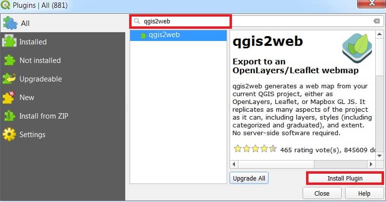
d) QGIS2Web
QGIS2Web allows users to export interactive web maps directly from QGIS using Leaflet or OpenLayers frameworks. It is widely used to share spatial data on the web without writing code.
Key Features:
- Export of styled QGIS maps to HTML/JavaScript
- Support for vector and raster layers
- Pop-ups, legend, and attribute filtering options
- Interactive web map creation without coding
Use Cases:
- Web-based GIS applications
- Public dissemination of spatial data
- Online interactive storytelling
e) SAGA (System for Automated Geoscientific Analyses)
SAGA GIS tools, integrated into QGIS via the Processing Toolbox, offer advanced geospatial analysis capabilities for raster and terrain processing. SAGA is well-known for its hydrological, terrain, and statistical tools.
Key Features:
- Flow direction and accumulation analysis
- Stream network and watershed delineation
- Terrain classification and slope/aspect analysis
- Multivariate statistical tools for spatial data analysis
Applications:
- Hydrologic terrain modeling
- Geomorphology and landform classification
- Soil erosion and slope instability analysis
Conclusion
As advance technology, GIS software continues to evolve—integrating AI, cloud computing, and real-time data processing—making it an indispensable tool for spatial analysis in the modern world.