GeoMedia Software Tutorial
What is GeoMedia?
GeoMedia is a powerful, flexible and dynamic GIS Management Solution application. It’s analyze Data, visualize location and gain other information from your data. Also It is a single unified map view for efficient processing, analysis, presentation, and sharing data, and provides simultaneous access to Geospatial Data.
GeoMedia’s functionality makes it ideal for extracting information from an array of dynamically changing data to support informed, smarter decision-making. It also combines tabular and geographic data to produce actionable information.
Uses:
Its used for;
- Creating a geographic data
- Managing geospatial databases
- Location intelligence and geographic data together
- Creating hard and soft-copy maps
- Joining business data
5 Important Features
- Get Real-Time Data for Smart Cities
- Generate Actionable Information for Public Safety
- Next-Level Automation for Utilities Network
- Safe and Maintained Roads for Travelers
- Fast Critical Decisions for Defense
GeoMedia Software
GeoMedia desktop viewer is a free application which allows for display map, simple analysis and output of Geo-Workspace data.
Geo-media using Erdas Imagine Software
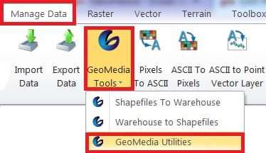
Geo-Media Utilities
GeoMedia utilities is creating various supporting files to load different warehouses in Erdas Imagine.
Click Manage Data tab > drop-down GeoMedia Tools > Click GeoMedia Utilities button in Connected Manager dialog.
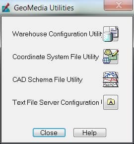
| Utility Name | Description |
|---|---|
| Warehouse Configuration | Create an .ini file to define a warehouse configuration file. Identify the data server name, workspace folder name, coordinate system file, and set values for keywords. |
| Coordinate System File | Define coordinate system type, storage unit and type, projection algorithm, spheroid and datums, measurement units. |
| CAD Schema File | Identify folders and maps for features, coordinate systems file, set feature definitions, and specify connection parameters. |
| Text File Server Configuration | Assign file type, non-uniform record, delimited data, fixed-width data, geometry, and attribute definitions. |
How to Use GeoMedia (Connection Manager)
- The Connection Manager dialog opens when you click Files of type dropdown arrow and select GeoMedia Warehouse Proxy (.gwp) in a File Selector, then click Connect.
- Icons show the current status of the specific connection-
 Connected Not connected.
How you work with GIS data in GeoMedia
This demonstration highlight the usabitity improvements in Geo-media. Once of the challenges for user have had being able to display both vector and data imagery accurately in different projection. Here’s quick example we change the Coordinate system and the imagery ends up not matching the vector data.
Geomedia now has an option to select advance Image processing, this will apply rigorous reprojection to the image, and give you the accuracy to need when re-projected.
Geo-media also enables easier exporting of data to Microsoft Excel. You can bring up a data window and select the data you need to export, and the easily copy and paste it into excel for further analysis.