Web GIS

WebGIS is a web services, that deliver data and capabilities, and connect components. It’s implementing a modern GIS. Web GIS is a cloud based web server on the Internet.

massgis maps

MassGIS Maps

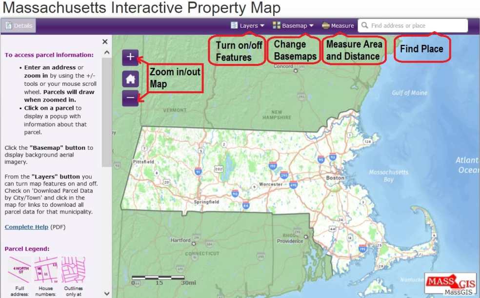
Massachusetts Bureau of Geographic Information (MassGIS) What is MassGIS? MassGIS is the Commonwealth’s Massachusetts Bureau of Geographic Information within the Executive Office of Technology Services and Security (EOTSS). It’s provides a large amount of public domain geographic data for Massachusetts. They distribute LiDAR, DEMs, and other elevation data, in addition to soils maps, hydrologic, cultural, […]

MassGIS Maps Read More »

Google GIS

Google GIS Tutorial Google provides an amazing feature, to create your own map with Geographic (GIS) Data. Create and Open Data in Google Map Create a Map 1. At first, sign in to Google My Maps. 2. Click Create a new map. 3. Go to the top left and click “Untitled map.” 4.Write the name

Google GIS Read More »

AWS GIS

AWS GIS

AWS/Amazon GIS What are AWS? AWS (Amazon Web Services) is an on-demand cloud computing platform and APIs for individuals, companies, and governments. These cloud computing web services provide various services related to networking, compute, storage, middle-ware, IoT and other processing capacity, as well as software tools via AWS server farms. What is AWS GIS? Amazon

AWS GIS Read More »

Tableau GIS

Tableau GIS Tutorial Tableau is a data visualization software created by Chris Stolte, Pat Hanrahan, and Christian Chabot in 2003. It is to provide the public with visualization software that would improve workflows. What is Tableau GIS? Tableau GIS is designed to make the most of geographical data, so you can get to the “where”

Tableau GIS Read More »

Link GIS Map Viewer

Link GIS Map Viewer Tutorial What is Link GIS? Link-GIS is an Northern Kentucky Geographic Information System. It is one of the nation’s pioneering GIS systems. In 1985 as a tool for one governmental agency to use in an environmental clean-up has become a wide-ranging service for a variety of public and private uses. How

Link GIS Map Viewer Read More »

Scroll to Top